This section of the Old Colony Nature Pathway in Provicetown, Massachusetts is an easy 0.9-mile out-and-back hike that features a quiet forest setting and leads to an eerie Atlantic White Cedar swamp.
Hike Description
This hike begins along Snail Road near the parking coordinates provided and heads west along the Old Colony Nature Pathway. The trail's substrate it mostly a sandy surface, but is generally easy to hike on.
Along the way, hikers will be walking behind private properties, so please stay on-trail at all times.
Whistle Path Woods - Mile 0.18
Around mile 0.18, hikers will reach a junction with the Whistle Path Woods Trail that leads north and south. The north terminus ends at MA-6 and the southern terminus end at a private property.
Fox Run Trail & Atlantic White Cedar Swamp - Mile 0.45
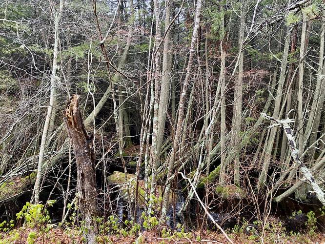
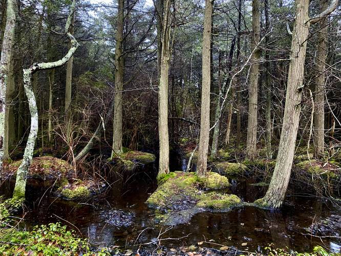
Around mile 0.45 is a junction with another small spur trail named the Fox Run Trail. In this area is a beautiful Atlantic White Cedar swamp with black waters, green mosses, and a dark understory. This is the main attraction for this hike. Note that the Atlantic White Cedar swamp begins slightly before mile 0.45 which can be enjoyed from this trail, but to get the best views of the eerie swamp, hike down the Fox Run Trail too.
History
As stated on the trailhead sign: "This trail was established in 1995 by the Provincetown community on the site of the historical Railroad Right-of-Way used by the Old Colony Railroad."
Parking
Hikers will find parking near the coordinates provided on Snail Road. Note the parking signs and do not park in in zones that prohibit it.
Pets
Per town rules as of April 2023: All dogs must be licensed and have a rabies vaccine. Dogs are allowed if leashed and must be cleaned up after. Off-leash Hours as follows - Memorial Day to Nov 1: 6AM - 9AM and 6PM - 9PM. Nov 2 to Memorial Day: 6AM - 9PM. Violations against not cleaning up and/or not obeying off-leash hours.
Hike Description
This hike begins along Snail Road near the parking coordinates provided and heads west along the Old Colony Nature Pathway. The trail's substrate it mostly a sandy surface, but is generally easy to hike on.
Along the way, hikers will be walking behind private properties, so please stay on-trail at all times.
Whistle Path Woods - Mile 0.18
Around mile 0.18, hikers will reach a junction with the Whistle Path Woods Trail that leads north and south. The north terminus ends at MA-6 and the southern terminus end at a private property.
Fox Run Trail & Atlantic White Cedar Swamp - Mile 0.45
Around mile 0.45 is a junction with another small spur trail named the Fox Run Trail. In this area is a beautiful Atlantic White Cedar swamp with black waters, green mosses, and a dark understory. This is the main attraction for this hike. Note that the Atlantic White Cedar swamp begins slightly before mile 0.45 which can be enjoyed from this trail, but to get the best views of the eerie swamp, hike down the Fox Run Trail too.
History
As stated on the trailhead sign: "This trail was established in 1995 by the Provincetown community on the site of the historical Railroad Right-of-Way used by the Old Colony Railroad."
Parking
Hikers will find parking near the coordinates provided on Snail Road. Note the parking signs and do not park in in zones that prohibit it.
Pets
Per town rules as of April 2023: All dogs must be licensed and have a rabies vaccine. Dogs are allowed if leashed and must be cleaned up after. Off-leash Hours as follows - Memorial Day to Nov 1: 6AM - 9AM and 6PM - 9PM. Nov 2 to Memorial Day: 6AM - 9PM. Violations against not cleaning up and/or not obeying off-leash hours.