The Oh! Susanna Trail at Mount Pisgah State Park in Troy, Pennsylvania is an easy 2.5-mile loop hike that features views of Stephen Foster Lake and Mount Pisgah.
Trails
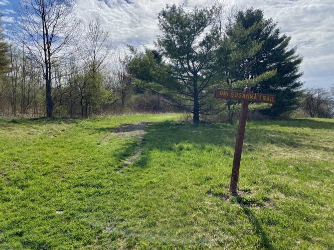
This hike follows one named trail: Oh! Susanna Trail (yellow blazes). The trail is well-marked by signage.
Hike Description
This hike begins at the eastern-most southern parking lot along the park's main entrance drive. The trail runs the eastern section of the parking lot, following grass, then crosses a wooden bridge. After the bridge, hikers will pass through a pine and maple forest - as of April 2023, there were tapped maple trees in the woods here.
Road Crossing, Grassy Path - Mile 0.4
Around mile 0.4, the trail will cross the entrance road where it'll switch to a grassy path for a while.
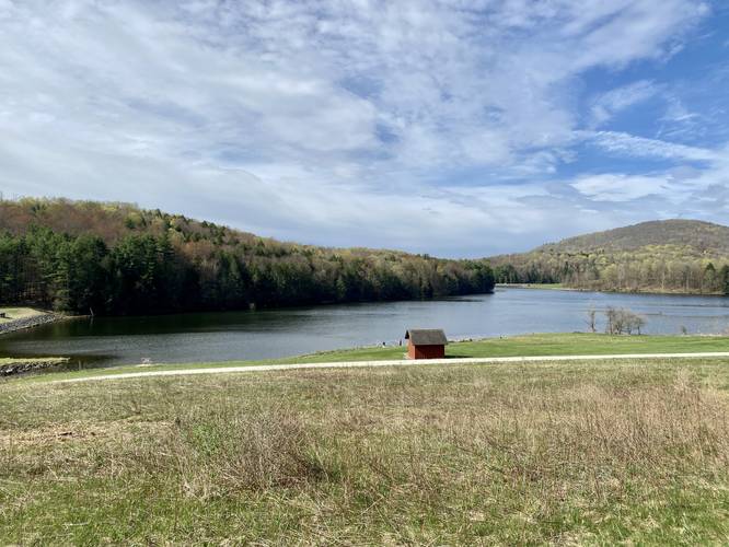
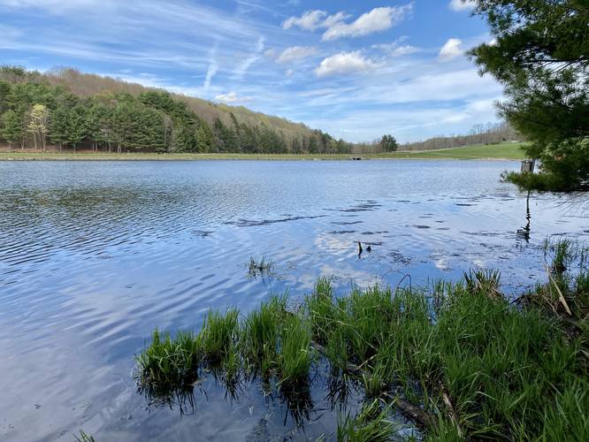
Lake Views - Mile 0.65
Around mile 0.65, hikers will reach the highest point on the grassy knoll above Stephen Foster Lake. Here you'll get views of the lake and Mount Pisgah sitting behind. From here, you'll also get some views facing downstream where the lake's spillway (human-made concrete slide waterfall) can be found. This spillway feeds Mill Creek.
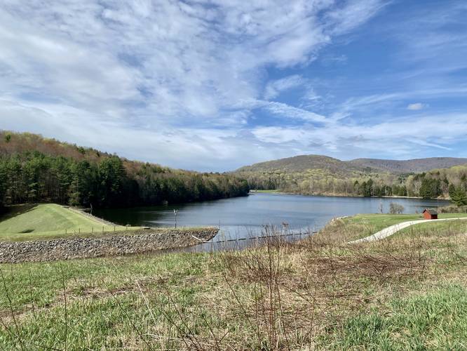
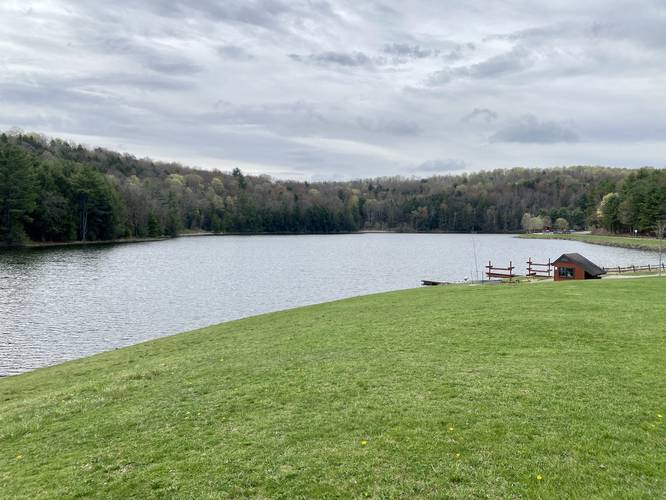
Dike Views - Mile 1
Hikers will follow the trail downhill, alongside the spillway, then over the bridge that crosses Mill Creek to reach the dike that sits on the northeast corner of Stephen Foster Lake. Here, you'll get more views of the lake and Mount Pisgah.
Pine Forest, Buggy - Mile 1 to 2
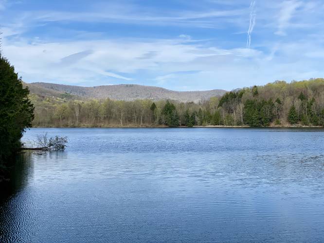
From mile 1 to mile 2, the hike passes through a mostly-open pine forest with several large boulders sitting in the woods off-trail. Not much to see here except for one off-trail walk that leads to the banks of Stephen Foster Lake at mile 1.5. Hikers will want to keep right at the trail junction at mile 1.55 as well. This section of the trail can be a bit buggy.
Road Hiking - Mile 2 to 2.35
At mile 2, hikers will reach Pisgah State Park Road where the trail will head north. There's a boardwalk that runs alongside the lake for a short while before hikers are spit out into the parking lot just up the road. Along the boardwalk we found turtles sunning themselves on the rocks in the pond during our hike in mid-April 2023. From the parking lot, after enjoying the views of the lake, the trail heads north adjacent to the road along the grass.
Grassy Knoll to Parking - Mile 2.35 to 2.5
Once on the grassy knoll, the trail heads up the hill without much of a true trail to follow and ends at the parking lot for a ~2.5-mile loop hike.
Parking
This hike begins at the large parking lot located after the first right-hand fork in the park road followed by a left-hand turn. Regardless, hikers can hop on this trail pretty much at any designated parking area at the state park as long as it's near water. Most of the parking lots are large enough to fit several dozen cars each.
Pets
Dogs are allowed if leashed and cleaned up after.
Trails
This hike follows one named trail: Oh! Susanna Trail (yellow blazes). The trail is well-marked by signage.
Hike Description
This hike begins at the eastern-most southern parking lot along the park's main entrance drive. The trail runs the eastern section of the parking lot, following grass, then crosses a wooden bridge. After the bridge, hikers will pass through a pine and maple forest - as of April 2023, there were tapped maple trees in the woods here.
Road Crossing, Grassy Path - Mile 0.4
Around mile 0.4, the trail will cross the entrance road where it'll switch to a grassy path for a while.
Lake Views - Mile 0.65
Around mile 0.65, hikers will reach the highest point on the grassy knoll above Stephen Foster Lake. Here you'll get views of the lake and Mount Pisgah sitting behind. From here, you'll also get some views facing downstream where the lake's spillway (human-made concrete slide waterfall) can be found. This spillway feeds Mill Creek.
Dike Views - Mile 1
Hikers will follow the trail downhill, alongside the spillway, then over the bridge that crosses Mill Creek to reach the dike that sits on the northeast corner of Stephen Foster Lake. Here, you'll get more views of the lake and Mount Pisgah.
Pine Forest, Buggy - Mile 1 to 2
From mile 1 to mile 2, the hike passes through a mostly-open pine forest with several large boulders sitting in the woods off-trail. Not much to see here except for one off-trail walk that leads to the banks of Stephen Foster Lake at mile 1.5. Hikers will want to keep right at the trail junction at mile 1.55 as well. This section of the trail can be a bit buggy.
Road Hiking - Mile 2 to 2.35
At mile 2, hikers will reach Pisgah State Park Road where the trail will head north. There's a boardwalk that runs alongside the lake for a short while before hikers are spit out into the parking lot just up the road. Along the boardwalk we found turtles sunning themselves on the rocks in the pond during our hike in mid-April 2023. From the parking lot, after enjoying the views of the lake, the trail heads north adjacent to the road along the grass.
Grassy Knoll to Parking - Mile 2.35 to 2.5
Once on the grassy knoll, the trail heads up the hill without much of a true trail to follow and ends at the parking lot for a ~2.5-mile loop hike.
Parking
This hike begins at the large parking lot located after the first right-hand fork in the park road followed by a left-hand turn. Regardless, hikers can hop on this trail pretty much at any designated parking area at the state park as long as it's near water. Most of the parking lots are large enough to fit several dozen cars each.
Pets
Dogs are allowed if leashed and cleaned up after.