The Mount Pisgah hike near Troy, Pennsylvania is a moderate 7-mile out-and-back hike that summits Mount Pisgah with a multitude of views along the way, including a vista at the summit and begins at Mount Pisgah State Park and ends within Mount Pisgah County Park.
Trails
This hike follows several named trails in order (one-way up the mountain) and follows the same trails for the opposite hike back to parking. The trails are as follows: Mill Stream Trail (white blazes) [state park], Snowmobile Trail (turquoise blazes) [state park], Ridge Trail (red blazes) [state park], Ridge Trail (yellow blazes) [county park], Shaylor Drive [county park road], Unnamed blue blazed trail to summit [county park].
Parks
This hike begins in Mount Pisgah State Park and ends in Mount Pisgah County Park. The hike is split in approximately half between both parks.
Hike Description
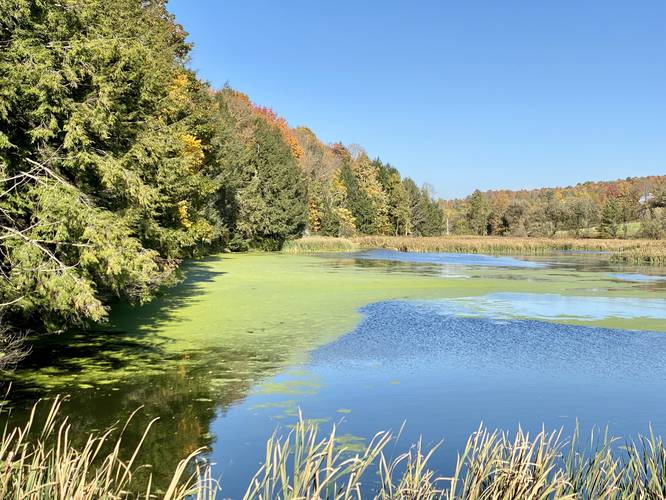
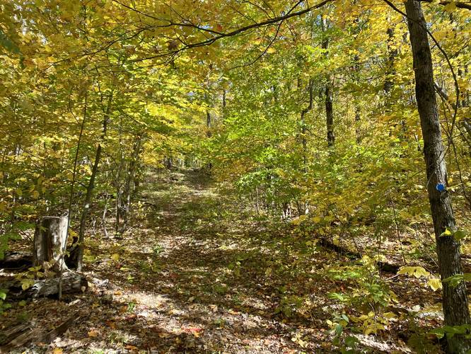
This hike begins at Mount Pisgah State Park at the Stephen Foster Lake parking area and follows Wetona Road north toward the Mill Stream Trail. Take the left-hand trailhead which heads up the hill and not along the water. Once on the Mill Stream Trail, hikers will follow white blazes leading up one of the steepest slopes on Mt. Pisgah, despite being right at the trailhead.
Reaching the Ridge Trail - Mile 0.35
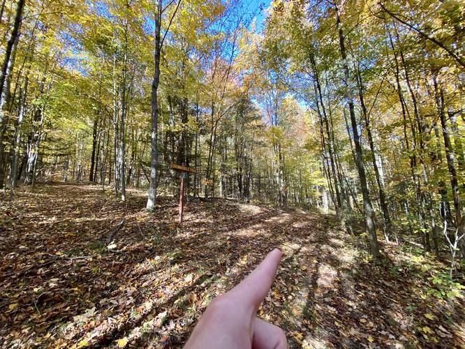
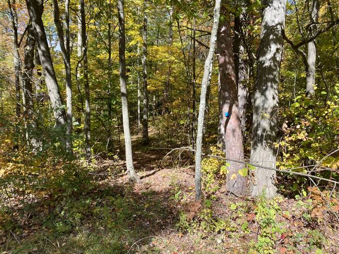
Along the way, hikers will pass several other trailhead signs - the key here is to first stay left to head onto the Snowmobile Trail, then stay right to keep on the Ridge Trail. Hikers will know they've reached the Ridge Trail if they notice the white birch trees at the trail junction. Once on the Ridge Trail, hikers will continue heading up the mountain along a mostly-moderate grade path that undulates a bit, giving you a break every now and then from the uphill climb.
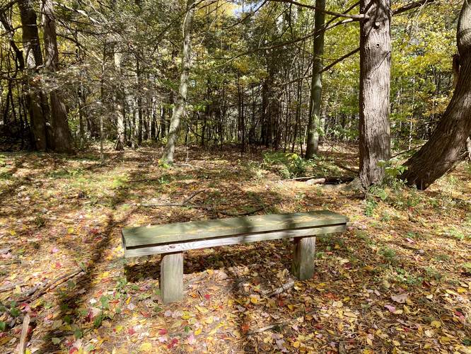
Benches - Mile 0.5 / 1.5 / 1.8
At mile 0.5 and 1.8, hikers will find a benches to rest.
Stay Right - Mile 0.65
Around mile 0.65, hikers will reach a junction with the Snowmobile Trail again, here you can stay right to keep on the Ridge Trail.
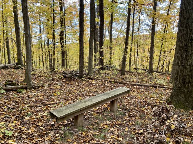
Hicks Hollow Trail Junction - Mile 1.5
At mile 1.5, hikers will reach a junction with the Hicks Hollow Trail where there's also a bench for resting. There's also a sign here stating the state park is 1.2 miles east, probably meant 1.5, and the county park line is 1.2-miles west.
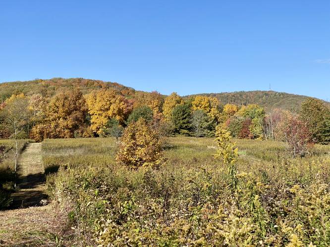
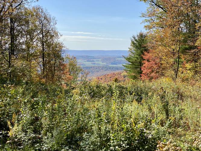
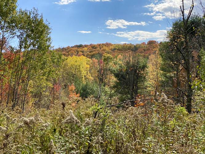
Mountain Meadow Vista - Mile 1.55
At mile 1.55, hikers will enter a mountain ridge meadow with views of the meadow's rolling hills and Mt Pisgah's summit, which has a radio/cell tower at the top.
Mount Pisgah County Park - Mile 2.3
At mile 2.3, hikers will enter the Mount Pisgah County Park, which follows the Ridge Trail through this park.
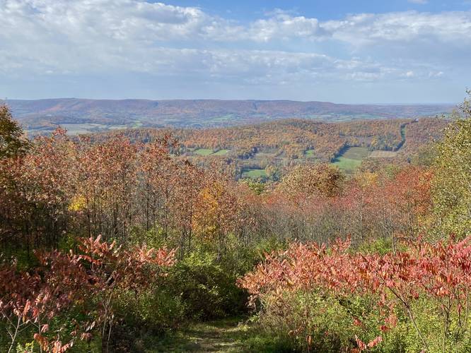
North / South Vistas - Mile 2.3 to 2.4
Just after entering the county park, hikers will be presented with two views of the neighboring farmland's rolling hills, which is an awesome sight during autumn's peak foliage. There's a small bit of walking to reach both views, but takes less than 0.1-miles to explore both.
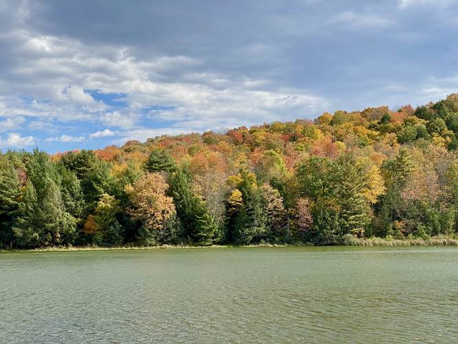
South Facing Vista - Mile 2.75
At mile 2.75, hikers will find a south-facing vista of the nearby farmland's rolling hills. This vista used to be bit more open, circa 2020, but is still a nice view regardless. There's also a picnic table at this view.
Road Junction / Left-Hand Turn to Blue Blazes - Mile 3.05
Around mile 3.05, hikers will reach a junction with the road that leads up to the top of Mount Pisgah, after passing a metal gate. Here, look for blue circular blazes nailed to the trees on the left-hand side of the road which sits across the street from the parking lot.
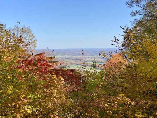
North Vista - Mile 3.05
Before hopping on the blue blazed trail, hikers can enjoy another north-facing vista here around mile 3.05.
Right-Hand Turn - Mile 3.2
At mile 3.2, follow the blue blazes up the mountain by taking a right-hand turn.
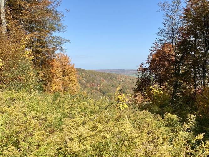
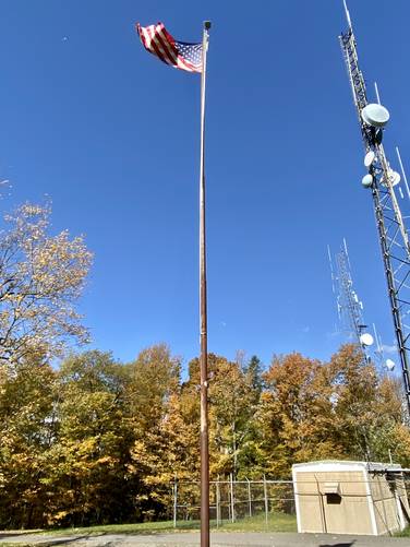
Mount Pisgah Summit & Vista - Mile 3.45 to 3.52
At mile 3.45, hikers will take the last right-hand turn that leads up to the summit of Mount Pisgah. Just before reaching the Native American statue, hikers will want to turn around to enjoy the beautiful rolling hills below them (Oak Hill) with Armenia Mountain in the background. During autumn, this vista pops with color and is well-worth the work to hike up to. Just beyond the vista is a pavilion that sits next to the mountain summit. Mount Pisgah's summit is marked with a flagpole as of Oct 15, 2022.
Hiking Out
The hike out obviously takes the opposite trails in, but is an enjoyable hike nonetheless. Take in the views on your way out to double your enjoyment on this 7-mile hike and don't forget to keep track of the turns you made on the way down.
Parking
Hikers will find a large parking lot at the coordinates provided. It's large enough to fit a couple dozen vehicles.
Pets
Dogs are allowed if leashed and their waste should be carried out by the hiker.
Warning
Lack of water: This trail has no water source along the route. It's smart to pack in at least 1-liter of water per person for cooler months and 2-liters of water per person during warmer or hot months.
Trails
This hike follows several named trails in order (one-way up the mountain) and follows the same trails for the opposite hike back to parking. The trails are as follows: Mill Stream Trail (white blazes) [state park], Snowmobile Trail (turquoise blazes) [state park], Ridge Trail (red blazes) [state park], Ridge Trail (yellow blazes) [county park], Shaylor Drive [county park road], Unnamed blue blazed trail to summit [county park].
Parks
This hike begins in Mount Pisgah State Park and ends in Mount Pisgah County Park. The hike is split in approximately half between both parks.
Hike Description
This hike begins at Mount Pisgah State Park at the Stephen Foster Lake parking area and follows Wetona Road north toward the Mill Stream Trail. Take the left-hand trailhead which heads up the hill and not along the water. Once on the Mill Stream Trail, hikers will follow white blazes leading up one of the steepest slopes on Mt. Pisgah, despite being right at the trailhead.
Reaching the Ridge Trail - Mile 0.35
Along the way, hikers will pass several other trailhead signs - the key here is to first stay left to head onto the Snowmobile Trail, then stay right to keep on the Ridge Trail. Hikers will know they've reached the Ridge Trail if they notice the white birch trees at the trail junction. Once on the Ridge Trail, hikers will continue heading up the mountain along a mostly-moderate grade path that undulates a bit, giving you a break every now and then from the uphill climb.
Benches - Mile 0.5 / 1.5 / 1.8
At mile 0.5 and 1.8, hikers will find a benches to rest.
Stay Right - Mile 0.65
Around mile 0.65, hikers will reach a junction with the Snowmobile Trail again, here you can stay right to keep on the Ridge Trail.
Hicks Hollow Trail Junction - Mile 1.5
At mile 1.5, hikers will reach a junction with the Hicks Hollow Trail where there's also a bench for resting. There's also a sign here stating the state park is 1.2 miles east, probably meant 1.5, and the county park line is 1.2-miles west.
Mountain Meadow Vista - Mile 1.55
At mile 1.55, hikers will enter a mountain ridge meadow with views of the meadow's rolling hills and Mt Pisgah's summit, which has a radio/cell tower at the top.
Mount Pisgah County Park - Mile 2.3
At mile 2.3, hikers will enter the Mount Pisgah County Park, which follows the Ridge Trail through this park.
North / South Vistas - Mile 2.3 to 2.4
Just after entering the county park, hikers will be presented with two views of the neighboring farmland's rolling hills, which is an awesome sight during autumn's peak foliage. There's a small bit of walking to reach both views, but takes less than 0.1-miles to explore both.
South Facing Vista - Mile 2.75
At mile 2.75, hikers will find a south-facing vista of the nearby farmland's rolling hills. This vista used to be bit more open, circa 2020, but is still a nice view regardless. There's also a picnic table at this view.
Road Junction / Left-Hand Turn to Blue Blazes - Mile 3.05
Around mile 3.05, hikers will reach a junction with the road that leads up to the top of Mount Pisgah, after passing a metal gate. Here, look for blue circular blazes nailed to the trees on the left-hand side of the road which sits across the street from the parking lot.
North Vista - Mile 3.05
Before hopping on the blue blazed trail, hikers can enjoy another north-facing vista here around mile 3.05.
Right-Hand Turn - Mile 3.2
At mile 3.2, follow the blue blazes up the mountain by taking a right-hand turn.
Mount Pisgah Summit & Vista - Mile 3.45 to 3.52
At mile 3.45, hikers will take the last right-hand turn that leads up to the summit of Mount Pisgah. Just before reaching the Native American statue, hikers will want to turn around to enjoy the beautiful rolling hills below them (Oak Hill) with Armenia Mountain in the background. During autumn, this vista pops with color and is well-worth the work to hike up to. Just beyond the vista is a pavilion that sits next to the mountain summit. Mount Pisgah's summit is marked with a flagpole as of Oct 15, 2022.
Hiking Out
The hike out obviously takes the opposite trails in, but is an enjoyable hike nonetheless. Take in the views on your way out to double your enjoyment on this 7-mile hike and don't forget to keep track of the turns you made on the way down.
Parking
Hikers will find a large parking lot at the coordinates provided. It's large enough to fit a couple dozen vehicles.
Pets
Dogs are allowed if leashed and their waste should be carried out by the hiker.
Warning
Lack of water: This trail has no water source along the route. It's smart to pack in at least 1-liter of water per person for cooler months and 2-liters of water per person during warmer or hot months.