Loading...

WINTER SALE! 50% OFF Supporter Accounts — now through January 31st. Learn More.

North Mountain Hike

This short section of the Shaw Butte Trail at North Mountain Park in Phoenix, Arizona is a moderate 2.2 mile out-and-back hike to the top of the first hill on North Mountain.

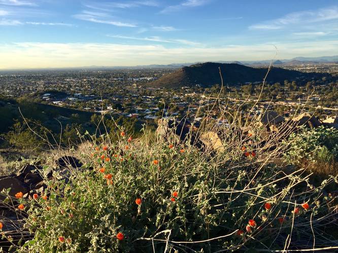
From the top of the hill, you get amazing views to the west, north, and east from North Mountain Park.

This hike starts off at the visitor center and follows Trail #100 (Charles M. Christiansen Memorial Trail) for 0.3 miles before hitting a trail junction - stay right at the junction to continue heading northwest through the park. Shortly after, about 0.2 miles from the first trail junction is yet another intersection - stay left to head toward the Shaw Butte Trail (#306). Take a left-hand turn on the Shaw Butte Trail and follow it until you reach a steeper uphill section - this is the climb up North Mountain to Shaw Butte.

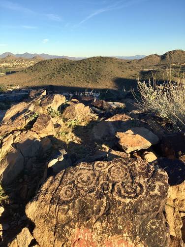
To reach the first lookout point (where this recording ends), hike for another 0.3 miles from where the trail heads uphill and start looking for a rock pile off to your left.

Petroglyphs: Petroglyphs can be found etched into rocks along the trail and at the lookout point.

Parking: Parking can be found at the coordinates provided at the North Mountain Visitor Center.
Explore 13 trails near Phoenix, AZ

Know Before You Go

  • The North Mountain Hike is a 2.2-mile roundtrip trail in Phoenix, Arizona, offering moderate difficulty and panoramic views.
  • The trail involves navigating junctions, including staying right at the first and left at the second, before ascending the Shaw Butte Trail.
  • Keep an eye out for petroglyphs along the trail and at the lookout point and parking is available at the North Mountain Visitor Center.
Interactive topographic map for North Mountain Hike located in Phoenix, AZ. Click the "View Map" button to load GPS coordinates and trail markers.
Get directions
Distance
2.2 mi
Difficulty
Moderate
Type
Out-and-Back
Est. Time
1.1 hrs
Elev. Gain
297'
Rating
0.0
Added
January 12, 2019
Updated
January 12, 2019

Weather Forecast

Loading...
Total Change
260'
Ascent
297'
Descent
297'
Loading...

Download the GPX Data for Offline Use

Supporters get exclusive access to download trail routes to the MyHikes app for offline use. Stay prepared on your adventure, even without an internet connection! Become a Supporter today to unlock this feature and hike with confidence.

Download North Mountain Hike GPX Data to the MyHikes Mobile App

Features

Vista / Lookout Point
Dogs
Biking

Points of interest

  1. Parking

    33.598725, -112.065988
  2. Main Trailhead

    33.598161, -112.066866

Safety information

For your own safety: plan ahead, let someone know where you'll be, and hike at your own risk.

Hazards

Snakes (Rattlesnakes, Copperheads, others)

Availability

All seasons

Surface type

Dirt

Trip Reports (Reviews)

Your opinion matters! Be the first to rate this trail.

Ready to help fellow hikers? Add a trip report to share your experience and provide valuable insights for other hikers!

No community routes found. To add your own hike as a Community Route for this Trail guide, leave a Trip Report with an attached GPX file.

Popular categories

Scenic mountain view representing vista trails
Vista trails
Scenic gorge of cascades representing waterfall trails
Waterfall hikes
Rugged mountain terrain representing summit trails
Summit trails
Scenic mountain view representing dog-friendly trails
Dog-friendly
Scenic campsite with a view representing camping trails
Camping trails
Appalachian Trail logo representing A.T. hikes
A.T. hikes

You May Also Like

Colorado's Million Dollar Highway - Plan a day's drive adventure along the iconic Million Dollar Highway in Colorado. Explore the best short trails, roadside stops, waterfalls, vistas, ghost towns, and hot springs within a ~6 hour road trip.
Explore

Colorado's Million Dollar Highway

Plan a day's drive adventure along the iconic Million Dollar Highway in Colorado. Explore the best short trails, roadside stops, waterfalls, vistas, ghost towns, and hot springs within a ~6 hour road trip.

Read
Glacier's Going-to-the-Sun Road - Discover the breathtaking beauty of Glacier National Park along the iconic Going-to-the-Sun Road. From stunning roadside stops to picturesque waterfalls and vistas, this engineering marvel offers endless opportunities for exploration.
Explore

Glacier's Going-to-the-Sun Road

Discover the breathtaking beauty of Glacier National Park along the iconic Going-to-the-Sun Road. From stunning roadside stops to picturesque waterfalls and vistas, this engineering marvel offers endless opportunities for exploration.

Read
🍪 We use cookies to learn about site usage and to serve map tiles. You may block cookies manually in the browser. By continuing you agree. Learn more