MyHikes Falls and Nessmuk's Rocks at Tioga State Forest near Wellsboro, Pennsylvania is a difficult 7.5-mile out-and-back hike that features the 17-foot tall waterfall, MyHikes Falls, and includes an off-trail bushwhack to Nessmuk's Rocks.
Trails
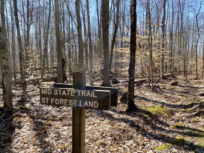
This hike follows the Mid State Trail (orange blazes) for 3-miles along a defined path. The first 0.9-miles is private property - hikers must stay-on trail at all times on that tract of land. After mile 3, the hike heads into the woods off-trail on a very-difficult-to-navigate bushwhack over to Nessmuk's Rocks. Folks without offline GPS tracking and navigation skills should not attempt to hike to Nessmuk's Rocks.
Hike Description
This hike begins along the Mid State Trail on Main Street just north of Antrim and Duncan villages in Pennsylvania, at the parking coordinates provided, and follows the Mid State Trail heading east. Along the first 0.9-miles of the hike, you'll be on private land so you must stay on-trail - doing so ensures this trail stays open to the public for the future. Along the way, hikers will undulate along hillsides along a rocky and sometimes mossy trail. Look out for random trail junctions along the way and always keep your eye on the next orange blaze so you don't accidentally go off-trail.
State Forest Land - Mile 0.9
At mile 0.9, hikers will reach the Tioga State Forest boundary - here you can go wherever you want, but this track continues following the Mid State Trail's orange blazes.
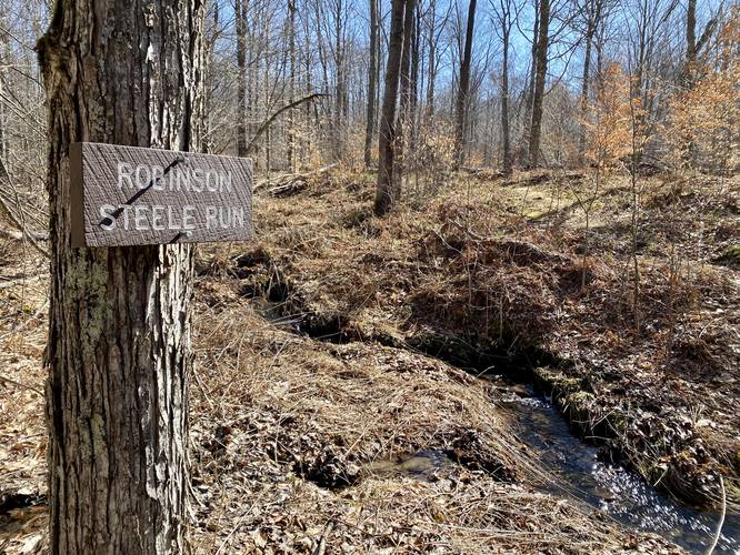
Robinson Steele Run - Mile 1.1
At mile 1.1, hikers will reach a small creek crossing with Robinson Steele Run. This creek is very small and easy to hop over. Decent water source for filtering if you need to.
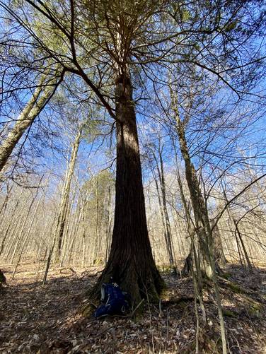
Old-Growth Hemlocks - Mile 1.8
Around mile 1.8, hikers will reach an old-growth hemlock grove. No measurements were taken on this hike, so as of March 2023, I'm unsure of the age of these trees.
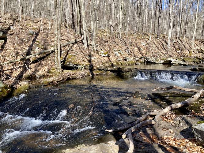
Small Waterfall - Mile 2.45
Around mile 2.45 is a small waterfall with a deep pool below - good for fishing or potentially wading in the Summer time.
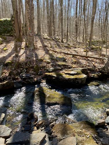
Creek Crossing & Small Cascade - Mile 2.65
At mile 2.65 hikers will reach a small waterfall, with another deep hole below for fishing or wading, with a creek crossing at Nickel Run just downstream. The creek crossing is not difficult as the mossy rocks provide some grip and extra slip-protection.
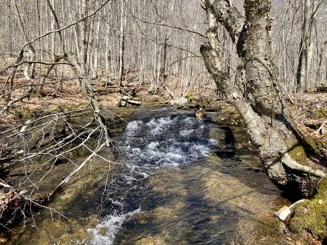
3-Foot Slide Waterfall - Mile 2.8 to 2.88
From mile 2.8 to 2.88 are three small scenic waterfalls - no taller than 3-foot maxiumum. At mile 2.8 is a 3-foot tall longer slide waterfall. At mile 3.88 are two waterfalls - a wide 2-footer upstream and a 2-foot slide waterfall downstream.
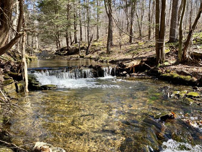
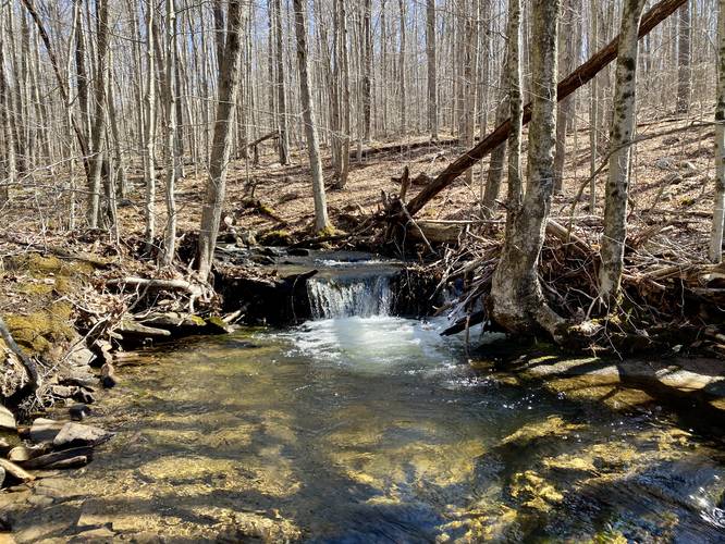
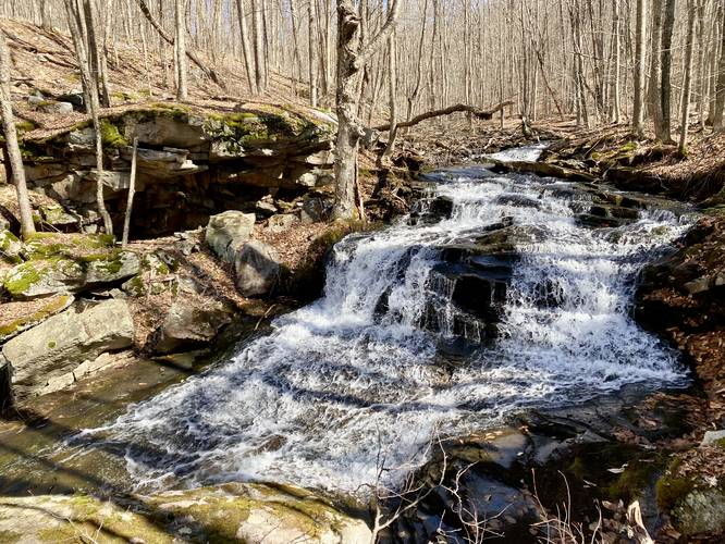
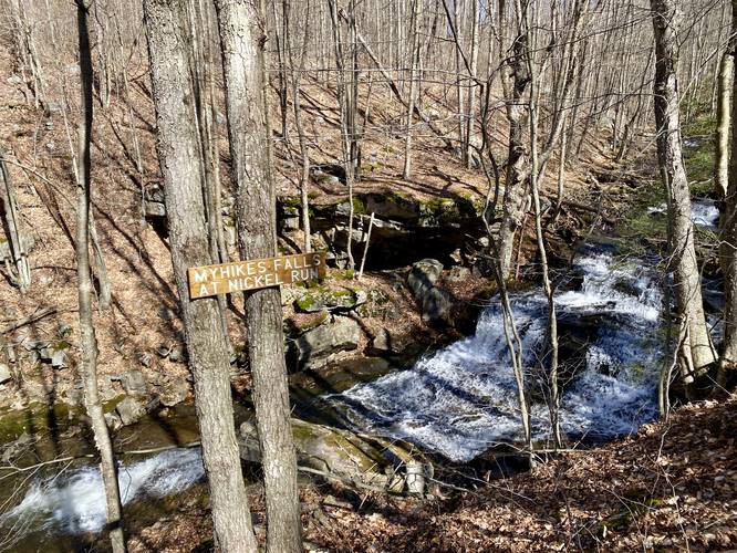
MyHikes Falls (17-feet tall) - Mile 2.9
Finally, at mile 2.9, hikers will reach the main attraction for this hike - MyHikes Falls. MyHikes Falls is split into two tiers of cascades - the upper tier being about 10-feet tall and the lower tier being about 7-feet or maybe slightly less. The entire waterfall is difficult to view during high water and due to the steep terrain that surrounds the cascades. There's also a neat rock cave between the two cascades of the waterfall that can fit at least one adult. Much like what the waterfall is named after, it's secluded and unpopular, but surprisingly awesome.
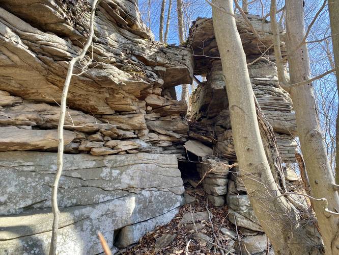
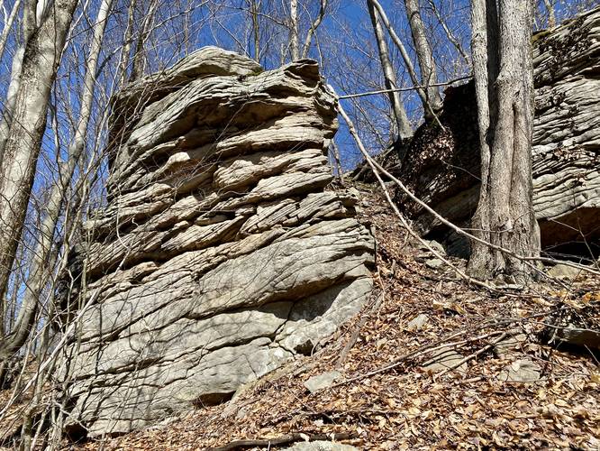
Bushwhack to Nessmuk's Rocks - Mile 2.9 to 3.75
After exploring MyHikes Falls, experienced off-trail bushwhack hikers, if they really care to can hike out to a rock ledge called Nessmuk's Rocks that features 8 to 15-foot tall rock ledges. If attempting to reach Nessmuk's Rocks you must have off-trail bushwhacking experience and carry an offline GPS tracker to ensure you don't get lost. This bushwhack off-trail hike begins at MyHikes Falls and heads southeast up the mountain. Once at the top, hikers will follow some short rocky ledges east, then back downhill to reach a mountain hollow. The forest along the way is not easy to navigate, even with no leaves on the trees. Along the way you may spot old roads that were carved through the forest - these are old logging roads, indicating that this area was logged maybe 20 to 30-years prior. Continuing to head east, hikers will eventually reach another mountain ridge top where Nessmuk's Rocks can be found. Nessmuk's Rocks wrap around the mountain top for about 350-feet. The rocks are easy to walk around and explore, but watch out for Rattlesnakes as they might call these rocks home. Once done at Nessmuk's Rocks, the hike out is a similar "identical" hike back to the Mid State Trail.
Hiking Out
Before hiking back to parking, stop at MyHikes Falls once more to enjoy the scenic cascading water. The hike up the Mid State Trail is enjoyable and not very difficult on the way out - mostly moderate at best. You also get to view the scenic smaller waterfalls on the way out too.
Parking
Hikers will find a small parking turnout at the coordinates provided on the east side of Main Street. The turnout can fit a few vehicles.
Pets
Dogs are allowed if leashed and must be cleaned up after.
Warnings
Timber Rattlesnake: This area is home to the Timber Rattlesnake which is often roaming the woods between April and October. Be on the lookout and give any rattlers you find plenty of space.
Bushwhack: After MyHikes Falls, this hike follows a complete bushwhack to reach Nessmuk's Rocks. Please do not attempt any off-trail hiking unless you have experience and know what you're doing.
Private Property: The first 0.9-miles of this trail is private property - you must stay on-trail.
Prohibited: No biking, no horses, no ATV or motorized vehicles anywhere on this trail. Foo traffic only.
POI Names
MyHikes Falls, was actually named by Mid State Trail Association Vice President, Peter Fleszar during a hike in June 2020 when I went with him to help re-blaze part of the trail system here. He thought it would be funny to add MyHikes Falls to Nickel Run and so did I (Dave Miller). Many folks might call this waterfall Upper Nickel Run Falls, but now a "MyHikes Falls at Nickel Run" sign appears on-trail here as an official point-of-interest. The name of the rocks is a nod to Nessmuk, who once had a winter camp located just below the top of the mountain - to explore Nessmuk's Winter Camp, checkout the Nickel Run Falls and Nessmuk's Winter Camp guide.
Trails
This hike follows the Mid State Trail (orange blazes) for 3-miles along a defined path. The first 0.9-miles is private property - hikers must stay-on trail at all times on that tract of land. After mile 3, the hike heads into the woods off-trail on a very-difficult-to-navigate bushwhack over to Nessmuk's Rocks. Folks without offline GPS tracking and navigation skills should not attempt to hike to Nessmuk's Rocks.
Hike Description
This hike begins along the Mid State Trail on Main Street just north of Antrim and Duncan villages in Pennsylvania, at the parking coordinates provided, and follows the Mid State Trail heading east. Along the first 0.9-miles of the hike, you'll be on private land so you must stay on-trail - doing so ensures this trail stays open to the public for the future. Along the way, hikers will undulate along hillsides along a rocky and sometimes mossy trail. Look out for random trail junctions along the way and always keep your eye on the next orange blaze so you don't accidentally go off-trail.
State Forest Land - Mile 0.9
At mile 0.9, hikers will reach the Tioga State Forest boundary - here you can go wherever you want, but this track continues following the Mid State Trail's orange blazes.
Robinson Steele Run - Mile 1.1
At mile 1.1, hikers will reach a small creek crossing with Robinson Steele Run. This creek is very small and easy to hop over. Decent water source for filtering if you need to.
Old-Growth Hemlocks - Mile 1.8
Around mile 1.8, hikers will reach an old-growth hemlock grove. No measurements were taken on this hike, so as of March 2023, I'm unsure of the age of these trees.
Small Waterfall - Mile 2.45
Around mile 2.45 is a small waterfall with a deep pool below - good for fishing or potentially wading in the Summer time.
Creek Crossing & Small Cascade - Mile 2.65
At mile 2.65 hikers will reach a small waterfall, with another deep hole below for fishing or wading, with a creek crossing at Nickel Run just downstream. The creek crossing is not difficult as the mossy rocks provide some grip and extra slip-protection.
3-Foot Slide Waterfall - Mile 2.8 to 2.88
From mile 2.8 to 2.88 are three small scenic waterfalls - no taller than 3-foot maxiumum. At mile 2.8 is a 3-foot tall longer slide waterfall. At mile 3.88 are two waterfalls - a wide 2-footer upstream and a 2-foot slide waterfall downstream.
MyHikes Falls (17-feet tall) - Mile 2.9
Finally, at mile 2.9, hikers will reach the main attraction for this hike - MyHikes Falls. MyHikes Falls is split into two tiers of cascades - the upper tier being about 10-feet tall and the lower tier being about 7-feet or maybe slightly less. The entire waterfall is difficult to view during high water and due to the steep terrain that surrounds the cascades. There's also a neat rock cave between the two cascades of the waterfall that can fit at least one adult. Much like what the waterfall is named after, it's secluded and unpopular, but surprisingly awesome.
Bushwhack to Nessmuk's Rocks - Mile 2.9 to 3.75
After exploring MyHikes Falls, experienced off-trail bushwhack hikers, if they really care to can hike out to a rock ledge called Nessmuk's Rocks that features 8 to 15-foot tall rock ledges. If attempting to reach Nessmuk's Rocks you must have off-trail bushwhacking experience and carry an offline GPS tracker to ensure you don't get lost. This bushwhack off-trail hike begins at MyHikes Falls and heads southeast up the mountain. Once at the top, hikers will follow some short rocky ledges east, then back downhill to reach a mountain hollow. The forest along the way is not easy to navigate, even with no leaves on the trees. Along the way you may spot old roads that were carved through the forest - these are old logging roads, indicating that this area was logged maybe 20 to 30-years prior. Continuing to head east, hikers will eventually reach another mountain ridge top where Nessmuk's Rocks can be found. Nessmuk's Rocks wrap around the mountain top for about 350-feet. The rocks are easy to walk around and explore, but watch out for Rattlesnakes as they might call these rocks home. Once done at Nessmuk's Rocks, the hike out is a similar "identical" hike back to the Mid State Trail.
Hiking Out
Before hiking back to parking, stop at MyHikes Falls once more to enjoy the scenic cascading water. The hike up the Mid State Trail is enjoyable and not very difficult on the way out - mostly moderate at best. You also get to view the scenic smaller waterfalls on the way out too.
Parking
Hikers will find a small parking turnout at the coordinates provided on the east side of Main Street. The turnout can fit a few vehicles.
Pets
Dogs are allowed if leashed and must be cleaned up after.
Warnings
Timber Rattlesnake: This area is home to the Timber Rattlesnake which is often roaming the woods between April and October. Be on the lookout and give any rattlers you find plenty of space.
Bushwhack: After MyHikes Falls, this hike follows a complete bushwhack to reach Nessmuk's Rocks. Please do not attempt any off-trail hiking unless you have experience and know what you're doing.
Private Property: The first 0.9-miles of this trail is private property - you must stay on-trail.
Prohibited: No biking, no horses, no ATV or motorized vehicles anywhere on this trail. Foo traffic only.
POI Names
MyHikes Falls, was actually named by Mid State Trail Association Vice President, Peter Fleszar during a hike in June 2020 when I went with him to help re-blaze part of the trail system here. He thought it would be funny to add MyHikes Falls to Nickel Run and so did I (Dave Miller). Many folks might call this waterfall Upper Nickel Run Falls, but now a "MyHikes Falls at Nickel Run" sign appears on-trail here as an official point-of-interest. The name of the rocks is a nod to Nessmuk, who once had a winter camp located just below the top of the mountain - to explore Nessmuk's Winter Camp, checkout the Nickel Run Falls and Nessmuk's Winter Camp guide.