Loading...

๐ŸŽ‰ Enjoy a Free 7-Day Supporter Trial and Unlock Exclusive Perks โ€” No Credit Card Required. Learn more.

Redwood Creek Loop Trail

Directions
Map
Pictures
Send to App
Distance:
0.9 Miles / 1.4 km
Type:
Loop
Difficulty:
Easy
Time to Hike:
~27 minutes
Surface Type:
Universal Access
Park:
Muir Woods National Monument
Town:
Mill Valley, California
Directions:
37.892006, -122.57045
Added:
May 16, 2018
Updated:
January 23, 2020
Copy Trail Link Hiking this trail? Send a friend or family member a link to this trail guide for your own safety. Hike at your own risk (disclaimer)
Loading...
Loading...
31'

Total Change
85'

Ascent
91'

Descent

Download the Trail Route for Offline Use

Supporters get exclusive access to download trail routes to the MyHikes app for offline use. Stay prepared on your adventure, even without an internet connection! Become a Supporter today to unlock this feature and hike with confidence.

Send to App

Redwood Creek Loop Trail

The Redwood Creek Loop Trail at Muir Woods National Monument in Mill Valley, California is an easy 0.9 mile loop hike that encompasses the portion of the Redwood Creek Trail from Bridge 3 to Bridge 1 and back (in this recording). This trail is probably the 2nd most popular trail people end up hiking at Muir Woods since it's paved, accessible, and flat.

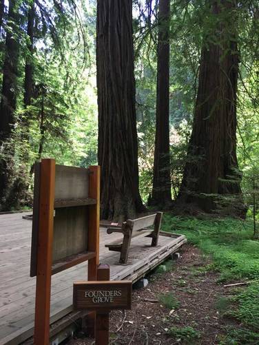
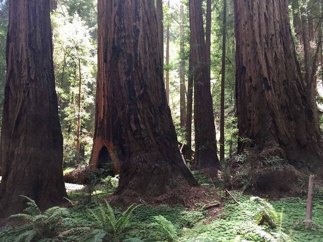
This recording starts at Bridge 3 and heads south to Bridge 1 and back, but you can start this loop directly after stepping into Muir Woods. You'll pass the Founders Grove, Bohemian Grove (with a redwood tree that you can stand inside of), and various other ancient coastal redwoods.

I found that the eastern side of this trail is a bit more interesting than the western side, but the western side has the Bohemian Grove while the eastern side has the Founders Grove. The Bohemian Grove is probably a bit more interesting to look at and can be found just south of Bridge 2.

For additional hiking and more redwoods, be sure to check out the rest of the Redwood Creek Trail, Hillside Trail, Fern Creek Trail, Lost Trail, and Canopy View Trail.

Fee: There's a $10 fee to enter Muir Woods for adults. For more information, check out their website.
Explore 28 trails near Mill Valley, CA
  1. Parking

    37.892006, -122.57045
  2. Main Trailhead

    37.897885, -122.575247
  3. Founders Grove

    37.894356, -122.574958
    Founders Grove
  4. Bohemian Grove

    37.895517, -122.575439
    Bohemian Grove
No community routes found. To add your own hike as a Community Route for this Trail guide, leave a Trip Report with an attached GPX file.

Hazards

Ticks - Lyme Disease More Info (CDC)

Seasons

All

Trip Reports

Trail Guide By:
Admin user profile picture
0.9 miles / 1.4 km

Weather Forecast

In Mill Valley, CA

Explore Hiking Trails

You May Also Like

Colorado's Million Dollar Highway - Plan a day's drive adventure along the iconic Million Dollar Highway in Colorado. Explore the best short trails, roadside stops, waterfalls, vistas, ghost towns, and hot springs within a ~6 hour road trip.
Explore

Colorado's Million Dollar Highway

Plan a day's drive adventure along the iconic Million Dollar Highway in Colorado. Explore the best short trails, roadside stops, waterfalls, vistas, ghost towns, and hot springs within a ~6 hour road trip.

Read
Glacier's Going-to-the-Sun Road - Discover the breathtaking beauty of Glacier National Park along the iconic Going-to-the-Sun Road. From stunning roadside stops to picturesque waterfalls and vistas, this engineering marvel offers endless opportunities for exploration.
Explore

Glacier's Going-to-the-Sun Road

Discover the breathtaking beauty of Glacier National Park along the iconic Going-to-the-Sun Road. From stunning roadside stops to picturesque waterfalls and vistas, this engineering marvel offers endless opportunities for exploration.

Read
New York's Best Waterfalls - Whether you're planning a day hike, roadside stop, or a leisurely short walk, this guide provides hikers, travelers, and locals alike with 63 different locations to over 100 scenic waterfalls to help plan your next adventure!
Explore

New York's Best Waterfalls

Whether you're planning a day hike, roadside stop, or a leisurely short walk, this guide provides hikers, travelers, and locals alike with 63 different locations to over 100 scenic waterfalls to help plan your next adventure!

Read

Before you boogie...

Find our trail guides useful? Consider becoming a Supporter to unlock perks!

MyHikes is an indie platform that makes exploring public trails easier for everyone. The platform has no investors, no ads, and is owned and operated by one person, Dave Miller. Dave has personally mapped and written over 1,800 trail guides on MyHikes for the public to explore. MyHikes has helped millions outdoor enthusiasts plan their next adventure.

But it takes a lot of time ๐Ÿ•ฆ, money ๐Ÿ’ฐ, work, and espresso shots โ˜• to run MyHikes, including hiking , mapping , writing , and publishing new trails with high-quality (accurate) information... along with software engineering (coding) the platform like building new features, website and mobile app development (iOS and Android), site maintainance . and much much more.

Supporters unlock website and mobile app perks with an annual one-time payment of $25 (you renew) ๐Ÿ˜Ž๐Ÿ‘. Or you can simply make a Donation of your choice. Otherwise, you can support us by telling your friends about MyHikes - both quick and free ๐ŸŽ‰

Admin user profile picture

Dave Miller
MyHikes Founder