Mt. Van Hoevenberg at Adirondack Park near North Elba, New York is a moderate 3.7-mile out-and-back hike that features a stunning overlook from the summit that provides views into the High Peaks Wilderness.
Trails
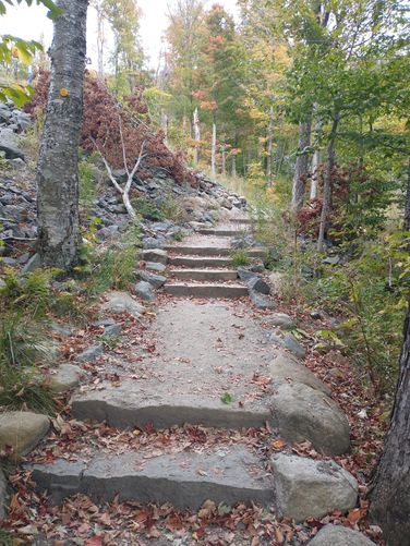
This hike follows one named trail: Mt. Van Hoevenberg Trail (yellow blazes).
Hike Description
This hike begins at the main parking area for the Mt. Van Hoevenberg Recreation Area. As of late January, 2023, Main Lot B or C can be used by day hikers to access the trail.
Locating the Trailhead
In order to find the trailhead, hikers must walk up and around the main building at the complex. Just behind the main building is a large bobsled run and adjacent to that is a small brown building with a sign labeled "Mt. Van Hoevenberg Olympic Bobsled Run" - look for a paved handrail pathway that leads along this building - this is your trail. At the time of this write-up, there was a brown state park sign on the ground near the concrete wall here for the Mt. Van Hoevenberg Trail.
Hikers will follow the abandoned bobsled run up and alongside this small brown building to reach the trail registry. At the trailhead registry, hikers can choose to sign in - remember to sign-out if signed-in.
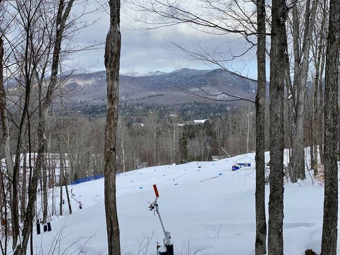
Ski Slope Views - Mile 0.2
Around mile 0.2, hikers will find ski trails cutting down that provide some half-decent views of Pitchoff Mountain. During the Winter (when this trail was mapped), we could see Cascade Mountain between the trees with some other obstructed and semi-decent views of the mountain; however, they did not come out well in photos.
Gradual Ascent - Mile 0.4 to 1
From miles 0.4 to 1, hikers will follow a more-gradual section of the trail as it winds its way toward a bend in the trail that eventually leads hikers up the mountain's eastern ridge. Once on the eastern ridge, the hike up is slightly more difficult (hence, the moderate rating), but hikers can take breaks along the way.
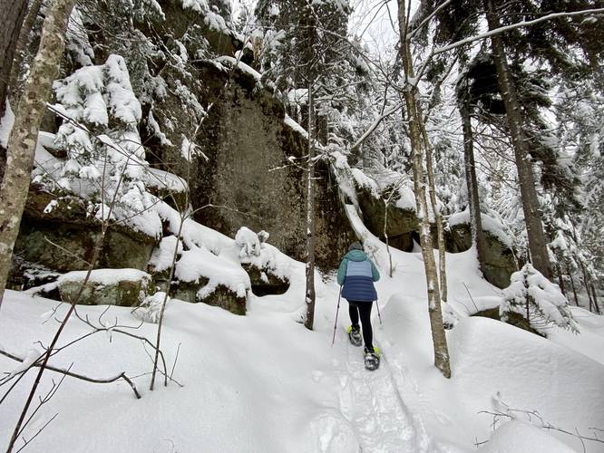
Rock Ledges / Ice Blobs - Mile 1.5
Around mile 1.5, hikers will find large rock ledges and outcroppings that provide a change of scenery - during the Winter, the water that seeps through these rocks ends up forming massive ice blobs. Note that during Winter hikes, this section of the mountain can generally be snow-covered, making for a magical wintry adventure.
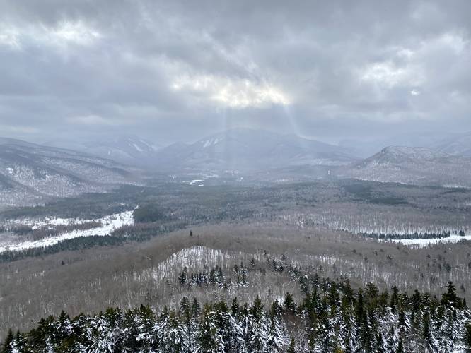
Summit Overlook - Mile 1.85
Finally, after passing a few bends in the trail, hikers will reach the summit of Mt. Van Hoevenberg where a small southward spur trail juts out to a rocky overlook that provides stunning views of the Adirondack's High Peaks Wilderness region. Hikers familiar with the area may spot some obvious mountains in view like Mount Jo sitting in the valley below or Wright Peak which neighbors and sits just below New York's second-tallest mountain, Algonquin Mountain which lies dead in the center. During the Winter, this vista provides unique views of the High Peaks' mountainous rock slides, known as the Wright Peak Angel Slides (covered in feet of snow), which backcountry snowboarders and skiers seek out to ride during this time of the year.
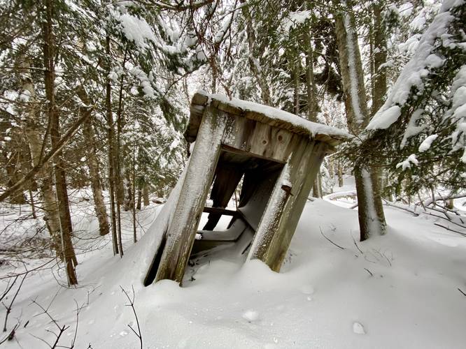
Abandoned Outhouse
As a weird but kind of interesting point-of-interest along this hike, there's a very very old abandoned outhouse located near the summit of Mt. Van Hoevenberg. It's unclear how old it truly is, but one would have to guess it must be decades upon decades old at this point. It lies just off-trail north of the trail between the summit and the overlook - leaning into the ground as if the earth is slowly trying to reclaim the wood it was built with.
Parking
Hikers will find massive parking lots at the Mt. Van Hoevenberg Recreation Area. Please park in the proper day-use hiker parking lots (see the signs as you drive in).
Pets
Dogs are allowed if leashed and their waste must be carried out by the hiker.
Trails
This hike follows one named trail: Mt. Van Hoevenberg Trail (yellow blazes).
Hike Description
This hike begins at the main parking area for the Mt. Van Hoevenberg Recreation Area. As of late January, 2023, Main Lot B or C can be used by day hikers to access the trail.
Locating the Trailhead
In order to find the trailhead, hikers must walk up and around the main building at the complex. Just behind the main building is a large bobsled run and adjacent to that is a small brown building with a sign labeled "Mt. Van Hoevenberg Olympic Bobsled Run" - look for a paved handrail pathway that leads along this building - this is your trail. At the time of this write-up, there was a brown state park sign on the ground near the concrete wall here for the Mt. Van Hoevenberg Trail.
Hikers will follow the abandoned bobsled run up and alongside this small brown building to reach the trail registry. At the trailhead registry, hikers can choose to sign in - remember to sign-out if signed-in.
Ski Slope Views - Mile 0.2
Around mile 0.2, hikers will find ski trails cutting down that provide some half-decent views of Pitchoff Mountain. During the Winter (when this trail was mapped), we could see Cascade Mountain between the trees with some other obstructed and semi-decent views of the mountain; however, they did not come out well in photos.
Gradual Ascent - Mile 0.4 to 1
From miles 0.4 to 1, hikers will follow a more-gradual section of the trail as it winds its way toward a bend in the trail that eventually leads hikers up the mountain's eastern ridge. Once on the eastern ridge, the hike up is slightly more difficult (hence, the moderate rating), but hikers can take breaks along the way.
Rock Ledges / Ice Blobs - Mile 1.5
Around mile 1.5, hikers will find large rock ledges and outcroppings that provide a change of scenery - during the Winter, the water that seeps through these rocks ends up forming massive ice blobs. Note that during Winter hikes, this section of the mountain can generally be snow-covered, making for a magical wintry adventure.
Summit Overlook - Mile 1.85
Finally, after passing a few bends in the trail, hikers will reach the summit of Mt. Van Hoevenberg where a small southward spur trail juts out to a rocky overlook that provides stunning views of the Adirondack's High Peaks Wilderness region. Hikers familiar with the area may spot some obvious mountains in view like Mount Jo sitting in the valley below or Wright Peak which neighbors and sits just below New York's second-tallest mountain, Algonquin Mountain which lies dead in the center. During the Winter, this vista provides unique views of the High Peaks' mountainous rock slides, known as the Wright Peak Angel Slides (covered in feet of snow), which backcountry snowboarders and skiers seek out to ride during this time of the year.
Abandoned Outhouse
As a weird but kind of interesting point-of-interest along this hike, there's a very very old abandoned outhouse located near the summit of Mt. Van Hoevenberg. It's unclear how old it truly is, but one would have to guess it must be decades upon decades old at this point. It lies just off-trail north of the trail between the summit and the overlook - leaning into the ground as if the earth is slowly trying to reclaim the wood it was built with.
Parking
Hikers will find massive parking lots at the Mt. Van Hoevenberg Recreation Area. Please park in the proper day-use hiker parking lots (see the signs as you drive in).
Pets
Dogs are allowed if leashed and their waste must be carried out by the hiker.