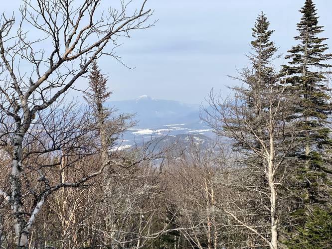
Wright Peak at Adirondack Park near North Elba, New York in the High Peaks Wilderness is a strenuous 6.6-mile out-and-back trail that leads to the top of Wright Peak mountain. The trail passes the 40-foot tall waterfall, MacIntyre Falls and features stunning views of the High Peaks Wilderness including the neighboring Algonquin Peak Mountain - the second-highest mountain in New York State. Note that this GPS recording stops just 0.2-miles below the actual summit due to extreme wind conditions above the treeline which made it impossible to continue.
Trails
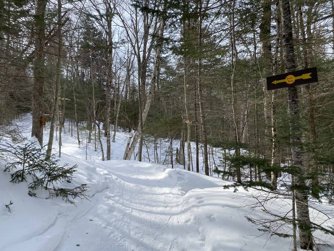
This hike follows several named trails in order: Heart Lake Loop Trail, Old Marcy Dam Trail, Algonquin Trail, Wright Trail. Please note that the signage for these trail junctions are not marked well, so bringing a physical map and offline mapping app or device will help a lot.
Hike Description
This recording begins at the Adirondack Loj and heads south along the Heart Lake Loop Trail. Hikers will follow the Heart Lake Loop until they reach the Leanto #9, where the trail takes a left-hand turn to follow the Old Marcy Dam Trail.
Old Marcy Dam Trail to Algonquin Trail
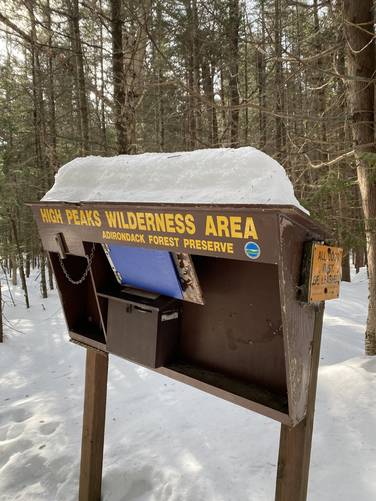
Once on the Old Marcy Dam Trail, hikers will quickly find a trail registry where they should sign-in in case of an emergency. After signing-in, hikers will follow this trail for about 1-mile. The key to following this trail is to take a right-hand turn at each trail junction. Eventually, the trail will slowly make its way uphill where it reaches the Algonquin Trail around mile 1.05.
Algonquin Trail - Mile 1.05
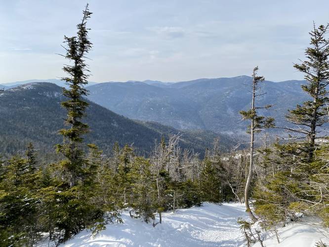
Around mile 1.05, hikers will reach the yellow blazes of the Algonquin Trail. This trail is where the difficult hiking begins. Between mile 1.05 and mile 1.7, the hiking is considered moderate at worst; however, around mile 1.7 is where the difficult and strenuous ascent begins, with very few flat grades along the way.
Campsites - Mile 2.22
Around mile 2.22, backpackers will find a campsite area located just off-trail. There's signage to make this area easier to find. The campsites are located just north of MacIntyre Falls. Note that no camping is allowed beyond MacIntyre Falls, so all backpackers and campers must setup camp north of MacIntyre Falls.
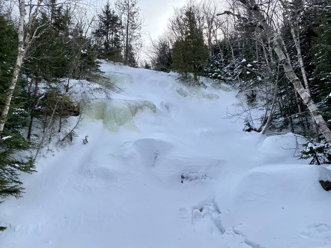
MacIntyre Falls - Mile 2.25
Around mile 2.25, hikers will reach the 40-foot tall MacIntyre Falls. During this hike, in February 2022, the waterfall was completely frozen over. During warm months, however, hikers will need to cross MacIntyre Brook to continue the hike. Due to the snowpack, it was impossible to tell how deep or wide MacIntyre Brook is - but wearing waterproof boots is probably useful here.
Mountain Rock Ledge - Mile 2.8
Around mile 2.8, hikers will reach a bench in the mountain (flat grade) where massive bedrock juts out of the ground to the northwest. Here, the trail skirts up a steep hillside - during the winter, this hillside can be very sketchy due to the steep 10-foot drop and the loose skinny footing provided along the sharp switchback. Just beyond this area, again during the winter, is where snow can pile-up from the wind, causing a massive snow drift. This snow drift can be extremely dangerous as it's over 6-feet tall and can easily break loose with enough force - causing the hiker to trigger a micro avalanche, sending them 6-feet down a steep slope into some gnarly pines.
Wright Trail Junction - Mile 3.05
Around mile 3.05, hikers will reach the junction with the Wright Trail which ascends Wright Peak. The total mileage is about 0.4-miles one-way to reach the summit of Wright Peak from this junction. Along the way, hikers will find very steep terrain. During the winter, some of this terrain feels a bit loose especially after the wind has been blowing the snow around.
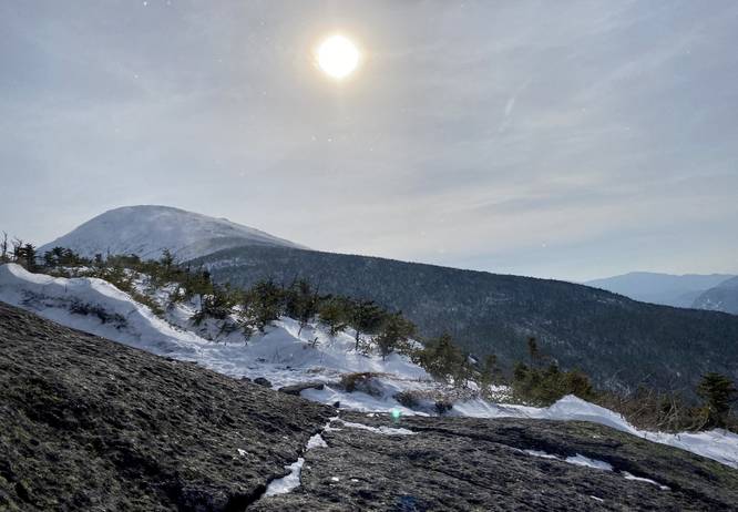
Rock Scramble to Wright Peak Summit - Mile 3.3
At mile 3.3, hikers will reach the rocky alpine terrain of Wright Peak. During the winter, this is the perfect spot to switch from snowshoes over to crampons to ensure safe footing as you make your way up to the summit. Additionally, this is where the treeline ends and the Arctic Alpine ecosystem beings. Here, very rare plants can be found growing - so please stay on the trail or rocks at all times and avoid stepping on plants. Last, due to the lack of trees, the wind here can become extreme. During this hike, the wind was moving at about 20mph in the valley below; however, on the summit, it felt like the wind was moving closer to 70mph or more! I could not stand up properly as the wind knocked me around (I'm 135lbs). I then attempted to crawl up to the summit to reduce the amount of wind on my body; however, the wind still pushed me over while I was basically hugging the ground. After about 0.1-miles one-way on the rock, I decided it wasn't safe enough to continue to the summit - I took some photos and videos - and began my descent. Honestly, the wind was really scary and the 3 other folks I talked to who were on the trail that day, who also attempted either Wright Peak or Algonquin Peak, said the same thing - they tried and gave up very very quickly due to the wind knocking them over.
Wright Peak Summit - Mile 3.5
Despite not recording all the way to the top, the trail does follow the rock face to the summit which is located just 0.2-miles from where this recording ends. Hikers get even better views from the summit since it allows you to peer eastward further into the High Peaks Wilderness.
Hiking Out
The descent along Wright Peak should be considered moderate at worst, despite the sketchy-sections of terrain along the way. I was able to ascent Wright Peak in about 2 hours and 10 minutes while the descent took no longer than 1 hour and 5 minutes, making for a ~3.5-hour hike; however, this was fast.
Parking
Hikers will find several massive parking lots at the coordinates provided. There is a fee to park. At the time of this writing (Feb 2022), it costs $7 for non-members for a half-day and $15 for a full day of parking. The parking lots are large enough to fit many dozens of vehicles; however, during the Summer months this lot fills up quickly, so show up early to claim a spot.
Pets
Dogs are allowed if leashed and their waste must be carried out by the hiker.
Warnings
Steep terrain: This hike follows some very steep terrain. Proper footwear and trekking poles are a must for this hike.
Snowshoes: During the winter months, snowshoes are required by law.
Wind speeds: At the top of Wright Peak, the wind may become extreme, depending on the weather conditions. Also note that the weather can change here faster than it does in the valleys.
Spindrifts and wind loading: This trail may have spindrifts where wind loading has piled up unstructured snow piles located on very steep terrain if the wind has been blowing hard. These snowdrifts can break away in a mini-avalanche, sending the hiker falling with it. While they're fairly small, you do not want to trigger a slide or get trapped in one, especially on very steep terrain.
Winter Conditions
If you plan to attempt Wright Peak during the winter you first need to get the right gear including: snowshoes, trekking poles, hiking crampons, waterproof gloves, and potentially a helmet for the rocky terrain. This mountain is more difficult than it appears, especially in winter conditions. If the weather forecast calls for high winds in the valleys, expect insanely-high winds above the treeline. These winds can be so forceful that it knocks people over and makes it impossible to actually summit, so plan accordingly. Also be aware of snowdrifts along the trail's steep terrain. These snowdrifts, if triggered, can cause micro avalanches which could either injure or bury the hiker.
Trails
This hike follows several named trails in order: Heart Lake Loop Trail, Old Marcy Dam Trail, Algonquin Trail, Wright Trail. Please note that the signage for these trail junctions are not marked well, so bringing a physical map and offline mapping app or device will help a lot.
Hike Description
This recording begins at the Adirondack Loj and heads south along the Heart Lake Loop Trail. Hikers will follow the Heart Lake Loop until they reach the Leanto #9, where the trail takes a left-hand turn to follow the Old Marcy Dam Trail.
Old Marcy Dam Trail to Algonquin Trail
Once on the Old Marcy Dam Trail, hikers will quickly find a trail registry where they should sign-in in case of an emergency. After signing-in, hikers will follow this trail for about 1-mile. The key to following this trail is to take a right-hand turn at each trail junction. Eventually, the trail will slowly make its way uphill where it reaches the Algonquin Trail around mile 1.05.
Algonquin Trail - Mile 1.05
Around mile 1.05, hikers will reach the yellow blazes of the Algonquin Trail. This trail is where the difficult hiking begins. Between mile 1.05 and mile 1.7, the hiking is considered moderate at worst; however, around mile 1.7 is where the difficult and strenuous ascent begins, with very few flat grades along the way.
Campsites - Mile 2.22
Around mile 2.22, backpackers will find a campsite area located just off-trail. There's signage to make this area easier to find. The campsites are located just north of MacIntyre Falls. Note that no camping is allowed beyond MacIntyre Falls, so all backpackers and campers must setup camp north of MacIntyre Falls.
MacIntyre Falls - Mile 2.25
Around mile 2.25, hikers will reach the 40-foot tall MacIntyre Falls. During this hike, in February 2022, the waterfall was completely frozen over. During warm months, however, hikers will need to cross MacIntyre Brook to continue the hike. Due to the snowpack, it was impossible to tell how deep or wide MacIntyre Brook is - but wearing waterproof boots is probably useful here.
Mountain Rock Ledge - Mile 2.8
Around mile 2.8, hikers will reach a bench in the mountain (flat grade) where massive bedrock juts out of the ground to the northwest. Here, the trail skirts up a steep hillside - during the winter, this hillside can be very sketchy due to the steep 10-foot drop and the loose skinny footing provided along the sharp switchback. Just beyond this area, again during the winter, is where snow can pile-up from the wind, causing a massive snow drift. This snow drift can be extremely dangerous as it's over 6-feet tall and can easily break loose with enough force - causing the hiker to trigger a micro avalanche, sending them 6-feet down a steep slope into some gnarly pines.
Wright Trail Junction - Mile 3.05
Around mile 3.05, hikers will reach the junction with the Wright Trail which ascends Wright Peak. The total mileage is about 0.4-miles one-way to reach the summit of Wright Peak from this junction. Along the way, hikers will find very steep terrain. During the winter, some of this terrain feels a bit loose especially after the wind has been blowing the snow around.
Rock Scramble to Wright Peak Summit - Mile 3.3
At mile 3.3, hikers will reach the rocky alpine terrain of Wright Peak. During the winter, this is the perfect spot to switch from snowshoes over to crampons to ensure safe footing as you make your way up to the summit. Additionally, this is where the treeline ends and the Arctic Alpine ecosystem beings. Here, very rare plants can be found growing - so please stay on the trail or rocks at all times and avoid stepping on plants. Last, due to the lack of trees, the wind here can become extreme. During this hike, the wind was moving at about 20mph in the valley below; however, on the summit, it felt like the wind was moving closer to 70mph or more! I could not stand up properly as the wind knocked me around (I'm 135lbs). I then attempted to crawl up to the summit to reduce the amount of wind on my body; however, the wind still pushed me over while I was basically hugging the ground. After about 0.1-miles one-way on the rock, I decided it wasn't safe enough to continue to the summit - I took some photos and videos - and began my descent. Honestly, the wind was really scary and the 3 other folks I talked to who were on the trail that day, who also attempted either Wright Peak or Algonquin Peak, said the same thing - they tried and gave up very very quickly due to the wind knocking them over.
Wright Peak Summit - Mile 3.5
Despite not recording all the way to the top, the trail does follow the rock face to the summit which is located just 0.2-miles from where this recording ends. Hikers get even better views from the summit since it allows you to peer eastward further into the High Peaks Wilderness.
Hiking Out
The descent along Wright Peak should be considered moderate at worst, despite the sketchy-sections of terrain along the way. I was able to ascent Wright Peak in about 2 hours and 10 minutes while the descent took no longer than 1 hour and 5 minutes, making for a ~3.5-hour hike; however, this was fast.
Parking
Hikers will find several massive parking lots at the coordinates provided. There is a fee to park. At the time of this writing (Feb 2022), it costs $7 for non-members for a half-day and $15 for a full day of parking. The parking lots are large enough to fit many dozens of vehicles; however, during the Summer months this lot fills up quickly, so show up early to claim a spot.
Pets
Dogs are allowed if leashed and their waste must be carried out by the hiker.
Warnings
Steep terrain: This hike follows some very steep terrain. Proper footwear and trekking poles are a must for this hike.
Snowshoes: During the winter months, snowshoes are required by law.
Wind speeds: At the top of Wright Peak, the wind may become extreme, depending on the weather conditions. Also note that the weather can change here faster than it does in the valleys.
Spindrifts and wind loading: This trail may have spindrifts where wind loading has piled up unstructured snow piles located on very steep terrain if the wind has been blowing hard. These snowdrifts can break away in a mini-avalanche, sending the hiker falling with it. While they're fairly small, you do not want to trigger a slide or get trapped in one, especially on very steep terrain.
Winter Conditions
If you plan to attempt Wright Peak during the winter you first need to get the right gear including: snowshoes, trekking poles, hiking crampons, waterproof gloves, and potentially a helmet for the rocky terrain. This mountain is more difficult than it appears, especially in winter conditions. If the weather forecast calls for high winds in the valleys, expect insanely-high winds above the treeline. These winds can be so forceful that it knocks people over and makes it impossible to actually summit, so plan accordingly. Also be aware of snowdrifts along the trail's steep terrain. These snowdrifts, if triggered, can cause micro avalanches which could either injure or bury the hiker.