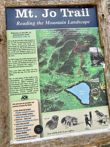
Mount Jo at Adirondack Park near North Elba, New York is a moderate to difficult 2.7-mile loop hike that features views of the High Peaks Wilderness area like Algonquin Peak, Mount Colden, and Wright Peak on a clear day and also includes a somewhat-challenging rock scramble along the Short Trail on the ascent.
Trails
This recording follows three named trails: Heart Lake Loop Trail (purple blazes), Short Trail (orange blazes; Mount Jo - Short Trail), and the Long Trail (red blazes; Mount Jo - Long Trail).
Hike Description
This hike begins at the Adirondack Loj and heads north along the Heart Lake Loop Trail. Just after passing a sign labeled "Rimrock", hikers will reach a larger sign with an arrow toward Mount Jo. Follow this orange-blazed trail north to reach a trail registry box - sign in, just in case something goes wrong.
Trail Junction - Steep and Long Trail Split
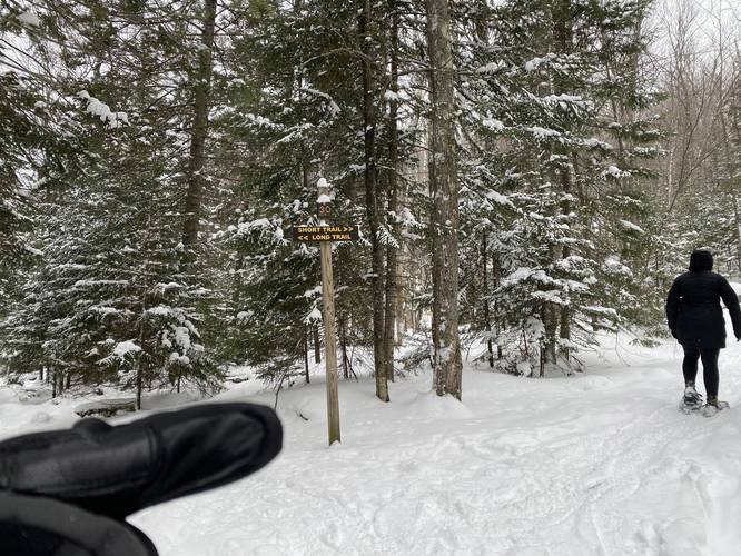
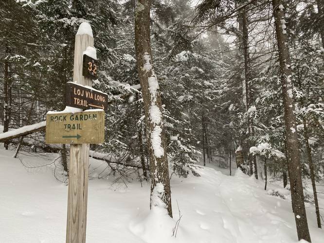
After passing the trail registry, the trail will reach a split - with signage for the "Long Trail" and "Short Trail". Hikers should note that the Short Trail should only be used for ascending Mount Jo, since descending on this trail could result in injury due to the steep and rocky terrain. This trek follows the Short Trail heading up the mountain and the Long Trail for the descent.
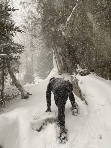
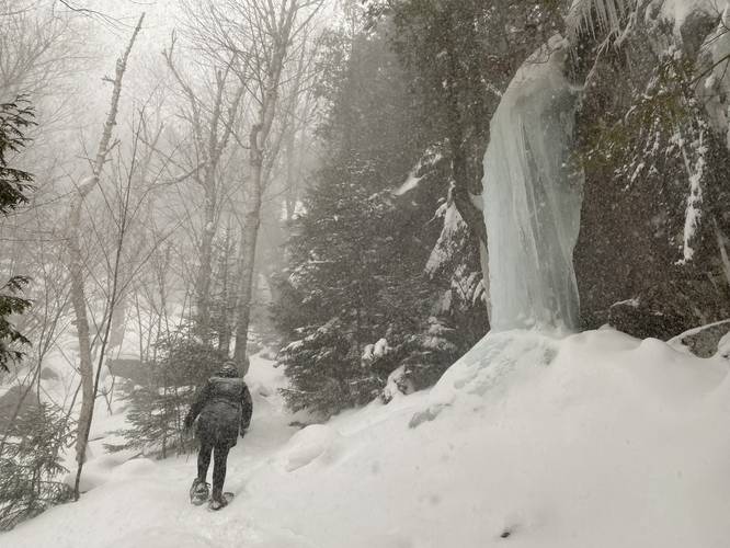
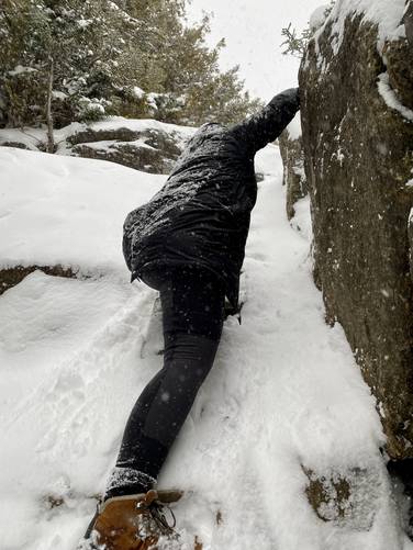
Ascending Mount Jo via Short Trail
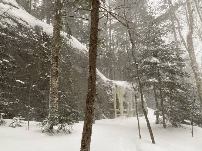
If the hiker chooses to take the Short Trail up the mountain, be prepared for some light rock scrambling as you make your way up. During the winter - when we hiked this - the rock scrambles are a bit more challenging when using snowshoes as they can get stuck in/on rocks and crevasses. Additionally, during the winter, hikers have to put their hands in snow and on ice in order to scramble up some of these rocks, so waterproof gloves are recommended. Either way, taking the Short Trail as slow as possible is preferred to assure the hiker ascends Mount Jo in one piece. Along the way, hikers may find a waterfall or two - no more than ~10-feet tall - cascading down the rock ledges to the side of the trail. When we tracked this during February, 2022 we found several ice falls; however, they might just be seasonal cascades.
Short Trail - Long Trail Junction
Just before the "bench" in the mountain - just 0.2 miles before the actual summit - both the Short Trail and Long Trail will meet up. Here, hikers ascending on the Short Trail will take a right-hand turn. If you ascended on the Long Trail - just head straight. Along the way there's a very large rock outcropping (note the short spur trail in the GPS data) where a short trail leads to. In the winter, you can't see anything but a snowy mound.
Staircase to Summit of Mount Jo
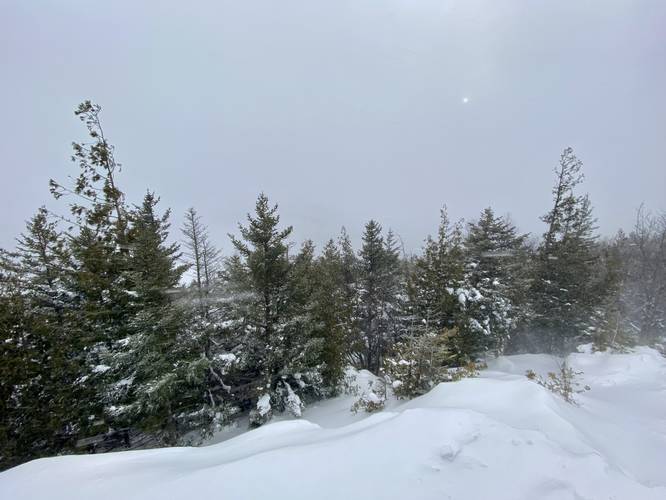
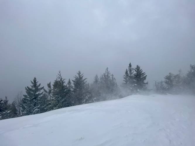
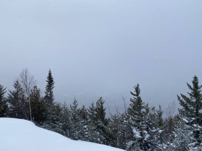
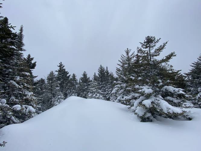
Just below the actual summit, hikers will reach a wooden staircase that leads up a steep rock face. During the winter, this staircase can be a challenge with the snowpack and ice - bring crampons, ice spikes, and trekking poles or and ice axe to help aid in getting up these stairs if necessary. After passing the stairs, the trail winds up and around some rock before following a sign labeled "summit" just 100-feet more to reach the actual bald-top summit of Mount Jo. On this ascent, the infrequent snow squalls made the beautiful stunning views of the High Peaks Wilderness totally washed out by the clouds and snow (but also makes for the perfect reason to hike this again).
Descending Mount Jo via Long Trail
After reaching the summit of Mount Jo - and taking in the views (if you're lucky to get them) - descending is certainly not as difficult as ascending via the Short Trail; however, that does not mean the hiker is not faced with challenges. There are numerous sections of the Long Trail that reach short, but steep grades of trail with rocks, roots, and trees. During those sections, hikers can use the trees to guide them down the trail. Other times, the trail will reach boulders that sit ~4-feet high, making you sit down to slide over. During the winter this can be a bit annoying with snowshoes. Overall, the Long Trail on the descent is not difficult and the challenging terrain is over fairly quickly, leaving a mostly-flat trail to follow back to the loop. This trail data follows the Heart Lake Loop Trail back to the Adirondack Loj to end the hike for ~2.7-miles total.
Difficulty
The average difficulty for this hike is moderate; however, that does not mean that hikers will not find the Short Trail "hard" or "strenuous" based on their own ability. The Short Trail, even for an avid hiker is not easy, especially with the rock scrambles.
Parking
Hikers will find parking at the coordinates provided at the main lots for the High Peaks Wilderness at the end of Adirondack Loj Road near North Elba, NY. The parking lots are large enough to fit many dozens of vehicles. There is a day-use and overnight parking fee for ~7/half-day, ~$15/full-day for non-members. Please check with the ADK for more information.
Pets
Dogs are allowed if leashed and their waste must be carried out by the hiker. Depending on the size of your dog, you may need to pick them up for some of the rock scrambles.
Warnings
Steep terrain: Along the Short Trail, hikers will find some challenging rock scrambles; however, they're not too difficult that a beginner cannot handle them. In the winter, they can be even more challenging due to the changes in terrain and lack of visibility on where you place your feet.
Rock scrambles: No matter what trail you take to ascend or descend Mount Jo, the hiker will be faced with some rock scrambling. The Long Trail has far less scrambling and at most, the hiker would have to scramble over a couple of 4-foot tall boulders on that trail. The Short Trail has a lot of scrambling.
Rock climbing: Technical rock climbing is not allowed on Mount Jo.
Trails
This recording follows three named trails: Heart Lake Loop Trail (purple blazes), Short Trail (orange blazes; Mount Jo - Short Trail), and the Long Trail (red blazes; Mount Jo - Long Trail).
Hike Description
This hike begins at the Adirondack Loj and heads north along the Heart Lake Loop Trail. Just after passing a sign labeled "Rimrock", hikers will reach a larger sign with an arrow toward Mount Jo. Follow this orange-blazed trail north to reach a trail registry box - sign in, just in case something goes wrong.
Trail Junction - Steep and Long Trail Split
After passing the trail registry, the trail will reach a split - with signage for the "Long Trail" and "Short Trail". Hikers should note that the Short Trail should only be used for ascending Mount Jo, since descending on this trail could result in injury due to the steep and rocky terrain. This trek follows the Short Trail heading up the mountain and the Long Trail for the descent.
Ascending Mount Jo via Short Trail
If the hiker chooses to take the Short Trail up the mountain, be prepared for some light rock scrambling as you make your way up. During the winter - when we hiked this - the rock scrambles are a bit more challenging when using snowshoes as they can get stuck in/on rocks and crevasses. Additionally, during the winter, hikers have to put their hands in snow and on ice in order to scramble up some of these rocks, so waterproof gloves are recommended. Either way, taking the Short Trail as slow as possible is preferred to assure the hiker ascends Mount Jo in one piece. Along the way, hikers may find a waterfall or two - no more than ~10-feet tall - cascading down the rock ledges to the side of the trail. When we tracked this during February, 2022 we found several ice falls; however, they might just be seasonal cascades.
Short Trail - Long Trail Junction
Just before the "bench" in the mountain - just 0.2 miles before the actual summit - both the Short Trail and Long Trail will meet up. Here, hikers ascending on the Short Trail will take a right-hand turn. If you ascended on the Long Trail - just head straight. Along the way there's a very large rock outcropping (note the short spur trail in the GPS data) where a short trail leads to. In the winter, you can't see anything but a snowy mound.
Staircase to Summit of Mount Jo
Just below the actual summit, hikers will reach a wooden staircase that leads up a steep rock face. During the winter, this staircase can be a challenge with the snowpack and ice - bring crampons, ice spikes, and trekking poles or and ice axe to help aid in getting up these stairs if necessary. After passing the stairs, the trail winds up and around some rock before following a sign labeled "summit" just 100-feet more to reach the actual bald-top summit of Mount Jo. On this ascent, the infrequent snow squalls made the beautiful stunning views of the High Peaks Wilderness totally washed out by the clouds and snow (but also makes for the perfect reason to hike this again).
Descending Mount Jo via Long Trail
After reaching the summit of Mount Jo - and taking in the views (if you're lucky to get them) - descending is certainly not as difficult as ascending via the Short Trail; however, that does not mean the hiker is not faced with challenges. There are numerous sections of the Long Trail that reach short, but steep grades of trail with rocks, roots, and trees. During those sections, hikers can use the trees to guide them down the trail. Other times, the trail will reach boulders that sit ~4-feet high, making you sit down to slide over. During the winter this can be a bit annoying with snowshoes. Overall, the Long Trail on the descent is not difficult and the challenging terrain is over fairly quickly, leaving a mostly-flat trail to follow back to the loop. This trail data follows the Heart Lake Loop Trail back to the Adirondack Loj to end the hike for ~2.7-miles total.
Difficulty
The average difficulty for this hike is moderate; however, that does not mean that hikers will not find the Short Trail "hard" or "strenuous" based on their own ability. The Short Trail, even for an avid hiker is not easy, especially with the rock scrambles.
Parking
Hikers will find parking at the coordinates provided at the main lots for the High Peaks Wilderness at the end of Adirondack Loj Road near North Elba, NY. The parking lots are large enough to fit many dozens of vehicles. There is a day-use and overnight parking fee for ~7/half-day, ~$15/full-day for non-members. Please check with the ADK for more information.
Pets
Dogs are allowed if leashed and their waste must be carried out by the hiker. Depending on the size of your dog, you may need to pick them up for some of the rock scrambles.
Warnings
Steep terrain: Along the Short Trail, hikers will find some challenging rock scrambles; however, they're not too difficult that a beginner cannot handle them. In the winter, they can be even more challenging due to the changes in terrain and lack of visibility on where you place your feet.
Rock scrambles: No matter what trail you take to ascend or descend Mount Jo, the hiker will be faced with some rock scrambling. The Long Trail has far less scrambling and at most, the hiker would have to scramble over a couple of 4-foot tall boulders on that trail. The Short Trail has a lot of scrambling.
Rock climbing: Technical rock climbing is not allowed on Mount Jo.