The Mt. Megunticook Hike at Camden Hills State Park in Camden, Maine is a moderate 2.8-mile loop (lollipop) hike that leads to several vistas along Mt. Megunticook's cliffs that feature views of the ocean, Camden and its harbor, and surrounding mountains.
Trails
This hike follows several named trails in the following order: Nature Trail (blue blazes), Mt. Megunticook Trail (yellow blazes), Adam's Lookout Trail (purple blazes), Tablelands Trail (red blazes), Ridge Trail (red blazes).
Hike
This hike begins at the main parking lot for Mt. Megunticook, located on Mt. Battie Road just west of the main campground area. Hikers will begin by following the blue blazes of the Nature Trail, with its trailhead located on the northwest corner of the parking lot. The trail leads into the woods and takes a right-hand turn to follow a series of stairs that leads over a very-muddy section of trail.
Mt. Megunticook Trail - Mile 0.3
At mile 0.3, hikers will take a left-hand turn to follow the yellow blazes (yellow stars) Mt. Megunticook Trail as it leads up switchbacks up the mountain. This part of the trail is more difficult than the Nature Trail section, but should not be considered much more than moderate at most.
Adam's Lookout Trail / Loop Begins - Mile 0.9
Around mile 0.9, hikers will reach a junction with the Adam's Lookout Trail (purple blazes). You have the choice here to follow the lollipop loop in either direction, but this route leads hikers to Adam's Lookout first, following the loop clockwise.
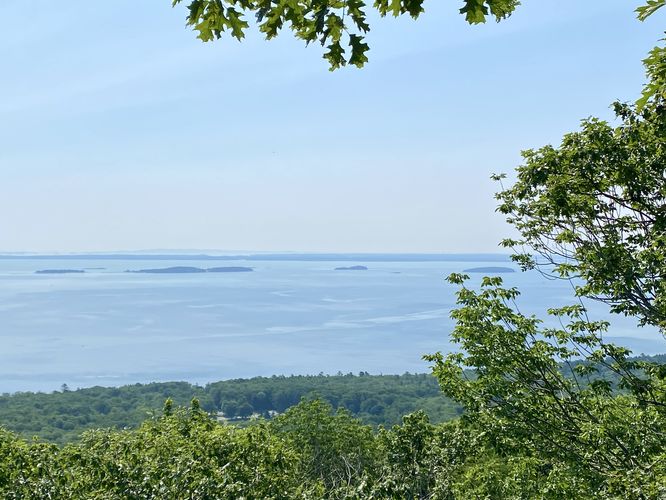
Adam's Lookout (Ocean View) - Mile 1
Hikers will reach Adam's Lookout after a bit more uphill hiking, around mile 1. Here, you'll find a nice view of the Atlantic Ocean and the islands located just off the coastline. This view is not spectacular, but it's a nice spot to take a break and hope that the wind passes through after the initial hike up the mountain. The hike is not over yet, as better views lie ahead on the trail. You'll backtrack here just slightly to reach a continuation of the purple blazed trail as it leads further up the mountain to reach the Tablelands Trail and the Ridge Trail.
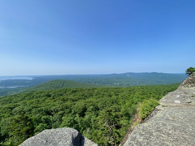
Ridge Trail & Views Begin - Mile 1.2
Around mile 1.2, hikers will reach a junction with the Tablelands Trail and the Ridge Trail. Here, take a right-hand turn off of the Tablelands Trail where it leads directly into the Ridge Trail. The Ridge Trail leads up bedrock to reach cliffs that sit along Mt. Megunticook's southern slopes and provides stunning views, starting around mile 1.22.
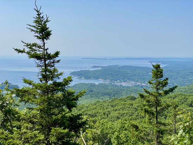
Mt. Megunticook Cliff Views of Camden - Mile 1.22 to 1.38
Starting around mile 1.22, hikers will reach the cliffs of Mt. Megunticook where you'll find panoramic views of Camden, its harbor, the Atlantic Ocean, and surrounding mountains in the distance. The views along these cliffs lasts for almost 0.2-miles as you hike your way up the mountain to explore further all of the vista points. Most of the views are the same, but you'll find different scenery and viewpoints, so make sure to take breaks before hiking down.
Mt. Megunticook Trail Loop - Mile 1.38 to 1.85
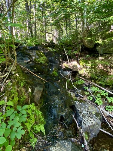
After exploring the bedrock cliff views of Mt. Megunticook, hikers may want to turn back to parking here. This route follows the Mt. Megunticook Trail back down to reach the Adam's Lookout Trail to make a loop (lollipop) out of this hike. Along the way down are two POI -- one viewpoint of the Atlantic Ocean and some offshore islands, located around mile 1.4, and one very-seasonal (mostly-dried-up) 5-foot tall waterfall located around mile 1.75. This waterfall is only worth stopping at after a period of consistent and heavy rainfall or during snowmelt season. Note that this part of the hike down the mountain is by-far the most difficult as you'll hike down bedrock with little drop-offs, making for a more difficult hike down.
Hiking Down - Mile 1.85 to 2.8
The hike back down the mountain is not difficult, starting around mile 1.85 (at the Adam's Lookout Trail). Make sure to take the proper right-hand turn at the Nature Trail and the proper left-hand turn to reach the parking lot to complete this moderate 2.8-mile loop hike.
Explore the Park Further
Before leaving the park, you might want to consider exploring the Mount Battie Vistas from that mountains summit for a quick walk and more stunning views.
Parking & Fees
There's a per-person entry fee, as of July 2024. For non-residents, it's a $6/adult fee. For Maine residents, the fee is $4/adult. Hikers will find parking at the lot located on Mt. Battie Road located just west of the campground area. The lot is large enough to fit a couple dozen vehicles as of July 2024.
Pets
Dogs are allowed only if leashed and must be cleaned up after.
Warning
Steep cliffs: This hike leads to and passes very steep and tall sheer cliffs. Hike at your own risk.
Trails
This hike follows several named trails in the following order: Nature Trail (blue blazes), Mt. Megunticook Trail (yellow blazes), Adam's Lookout Trail (purple blazes), Tablelands Trail (red blazes), Ridge Trail (red blazes).
Hike
This hike begins at the main parking lot for Mt. Megunticook, located on Mt. Battie Road just west of the main campground area. Hikers will begin by following the blue blazes of the Nature Trail, with its trailhead located on the northwest corner of the parking lot. The trail leads into the woods and takes a right-hand turn to follow a series of stairs that leads over a very-muddy section of trail.
Mt. Megunticook Trail - Mile 0.3
At mile 0.3, hikers will take a left-hand turn to follow the yellow blazes (yellow stars) Mt. Megunticook Trail as it leads up switchbacks up the mountain. This part of the trail is more difficult than the Nature Trail section, but should not be considered much more than moderate at most.
Adam's Lookout Trail / Loop Begins - Mile 0.9
Around mile 0.9, hikers will reach a junction with the Adam's Lookout Trail (purple blazes). You have the choice here to follow the lollipop loop in either direction, but this route leads hikers to Adam's Lookout first, following the loop clockwise.
Adam's Lookout (Ocean View) - Mile 1
Hikers will reach Adam's Lookout after a bit more uphill hiking, around mile 1. Here, you'll find a nice view of the Atlantic Ocean and the islands located just off the coastline. This view is not spectacular, but it's a nice spot to take a break and hope that the wind passes through after the initial hike up the mountain. The hike is not over yet, as better views lie ahead on the trail. You'll backtrack here just slightly to reach a continuation of the purple blazed trail as it leads further up the mountain to reach the Tablelands Trail and the Ridge Trail.
Ridge Trail & Views Begin - Mile 1.2
Around mile 1.2, hikers will reach a junction with the Tablelands Trail and the Ridge Trail. Here, take a right-hand turn off of the Tablelands Trail where it leads directly into the Ridge Trail. The Ridge Trail leads up bedrock to reach cliffs that sit along Mt. Megunticook's southern slopes and provides stunning views, starting around mile 1.22.
Mt. Megunticook Cliff Views of Camden - Mile 1.22 to 1.38
Starting around mile 1.22, hikers will reach the cliffs of Mt. Megunticook where you'll find panoramic views of Camden, its harbor, the Atlantic Ocean, and surrounding mountains in the distance. The views along these cliffs lasts for almost 0.2-miles as you hike your way up the mountain to explore further all of the vista points. Most of the views are the same, but you'll find different scenery and viewpoints, so make sure to take breaks before hiking down.
Mt. Megunticook Trail Loop - Mile 1.38 to 1.85
After exploring the bedrock cliff views of Mt. Megunticook, hikers may want to turn back to parking here. This route follows the Mt. Megunticook Trail back down to reach the Adam's Lookout Trail to make a loop (lollipop) out of this hike. Along the way down are two POI -- one viewpoint of the Atlantic Ocean and some offshore islands, located around mile 1.4, and one very-seasonal (mostly-dried-up) 5-foot tall waterfall located around mile 1.75. This waterfall is only worth stopping at after a period of consistent and heavy rainfall or during snowmelt season. Note that this part of the hike down the mountain is by-far the most difficult as you'll hike down bedrock with little drop-offs, making for a more difficult hike down.
Hiking Down - Mile 1.85 to 2.8
The hike back down the mountain is not difficult, starting around mile 1.85 (at the Adam's Lookout Trail). Make sure to take the proper right-hand turn at the Nature Trail and the proper left-hand turn to reach the parking lot to complete this moderate 2.8-mile loop hike.
Explore the Park Further
Before leaving the park, you might want to consider exploring the Mount Battie Vistas from that mountains summit for a quick walk and more stunning views.
Parking & Fees
There's a per-person entry fee, as of July 2024. For non-residents, it's a $6/adult fee. For Maine residents, the fee is $4/adult. Hikers will find parking at the lot located on Mt. Battie Road located just west of the campground area. The lot is large enough to fit a couple dozen vehicles as of July 2024.
Pets
Dogs are allowed only if leashed and must be cleaned up after.
Warning
Steep cliffs: This hike leads to and passes very steep and tall sheer cliffs. Hike at your own risk.