Mt. Marcy within Adirondack Park's High Peaks Wilderness near Lake Placid, New York is a strenuous 14.5-mile out-and-back hike that leads to the summit of Mount Marcy, New York State's highest point, and features beautiful views along the way.
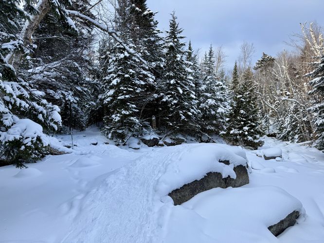
The hike begins at the ADK Loj at the main trailhead for the Van Hoevenberg Trail and follows the blue blazes of the trail as it leads southward toward Marcy Dam. The hiking is easy out to Marcy Dam, just follow the blue blazes and signs for either Marcy Dam / Mt. Marcy. Hikers will cross a footbridge above MacIntyre Brook, officially enter the High Peaks Wilderness, and enjoy a peaceful forest setting as you make your way out to the dam.
Parking & Fees
Hikers will find a massive parking lot at the coordinates provided at the Adirondack Mountain Club. The parking lots are large enough to fit many dozens of vehicles. As of January 2025, there's a $18 daily fee to park at the Adirondack Mountain Club's parking lot.
Winter spindrifts and wind loading: During winter, this trail may have spindrifts where wind loading has piled up unstructured snow piles located on very steep terrain if the wind has been blowing hard or just after a heavy snowfall with fast winds.
Winter spruce traps: Along the last push to the summit, the snow pack can be extremely deep (sometimes over 6-feet), thus it buries the spruce trees that grow there. Due to this, if you accidentally step on the top of a tree, you may fall into the loosely-packed snow that surrounds it, causing you to fall over and get your snowshoes to get stuck in the branches. It's best to try and stay on the packed-in snowshoe trail for this reason.
Trails
This hike follows one named trail: Van Hoevenberg Trail (blue blazes).Hiking to Mt. Marcy's Summit
This hike was done in January 2025 as a winter ascent. Most hikers will complete Mt. Marcy during warmer months, however, if planning on a winter ascent you must wear the proper gear and mountaineering snowshoes.The hike begins at the ADK Loj at the main trailhead for the Van Hoevenberg Trail and follows the blue blazes of the trail as it leads southward toward Marcy Dam. The hiking is easy out to Marcy Dam, just follow the blue blazes and signs for either Marcy Dam / Mt. Marcy. Hikers will cross a footbridge above MacIntyre Brook, officially enter the High Peaks Wilderness, and enjoy a peaceful forest setting as you make your way out to the dam.
Marcy Dam - Mile 2.2
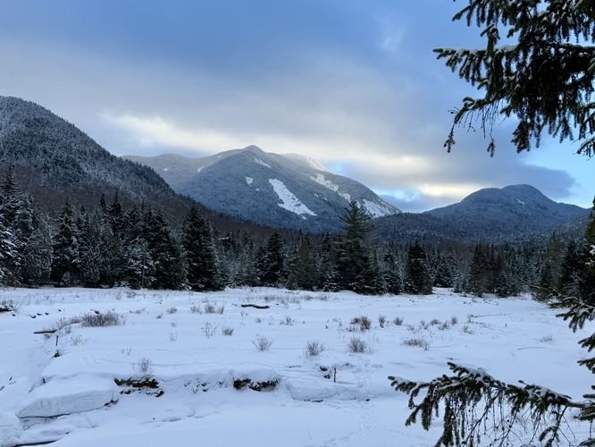
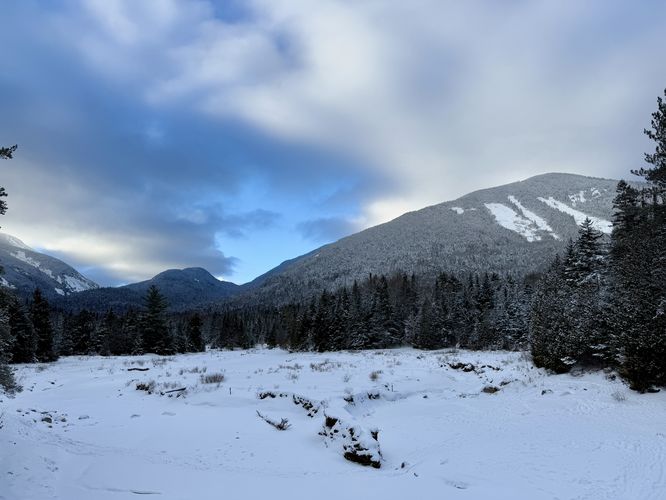
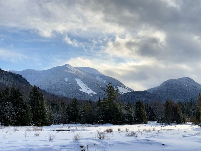
Around mile 2.2, hikers with reach the long-abandoned Marcy Dam. From the dam are stunning views into the High Peaks Wilderness of Mount Colden. You can also take the time to appreciate the engineering and effort that people once put into building this massive dam. If you linger around long enough, you can still smell the oils used to help preserve the timber of the dam.Marcy Dam to Indian Falls Lookout - Mile 2.2 to 4.5
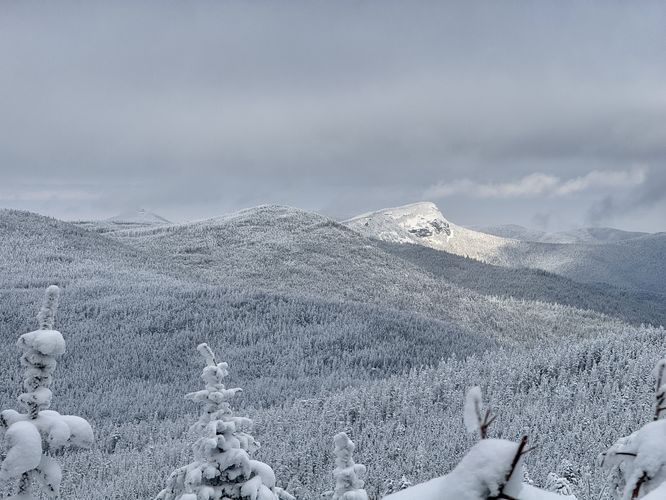
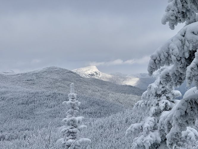
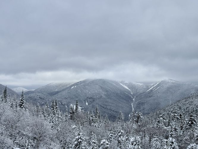
The hike up Mt. Marcy from Marcy Dam is pretty straight forward once you pass the Marcy Dam Backcountry Campsite area. To reach the campsite area, simply hike north from Marcy Dam to reach a footbridge that spans Marcy Brook. Once on the east side of Marcy Dam, the trail leads to views of Wright Peak with its exposed bedrock called the Angel Slides. Wright Peak's Angel Slides are popular with backcountry skiers during the winter. The trail leads into the Marcy Dam Backcountry Campsite area where you'll find a trail registry. If you wish, you can sign-in here for your own safety in case something were to happen. The trail then wraps around the campsite area before it heads up the mountain following Phelps Brook. Once you start following Phelps Brook, you'll find the trail follows a moderate grade. The trail has one creek crossing around mile 2.68, which during the winter is super easy, but might be more difficult during warm months. You'll also pass the last campsite on the trail around mile 3.1. At mile 3.35, you'll pass the Phelps Mountain Trail -- keep right to stay on the Van Hoevenberg Trail. Around mile 3.58, you'll cross another footbridge that spans Phelps Brook. Right after the footbridge, the trail follows a steeper grade, and some switchbacks, up to reach Indian Falls. This is the first difficult pitch of uphill hiking but doesn't last too long. Near the top of this plateau is a trail junction -- keep right to cross Marcy Brook. Look for an unmarked trail on the right-hand side, which leads to the top of Indian Falls and a stunning vista of the MacIntyre Range -- Wright Peak and Algonquin, Boundary, and Iroquois Peaks. While this view is from the very-top of Indian Falls, during warm months you can hike out to a Indian Falls Lookout point (not described in this route), located just down the trail, to see the waterfall when it's not frozen over. The hike up to the summit of Mount Marcy is far from over here though, so prepare for more uphill hiking.Indian Falls to Phelps Trail - Mile 4.5 to 6.73
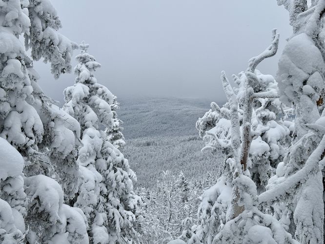
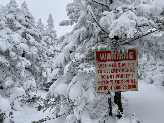
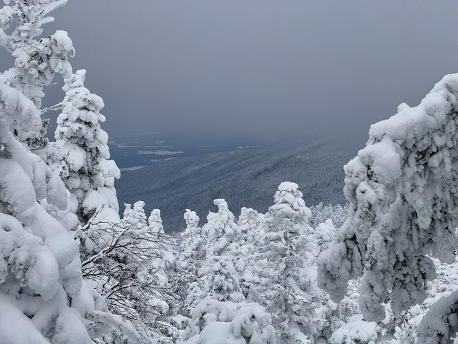
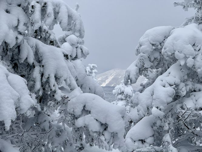
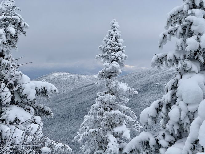
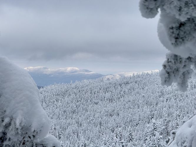
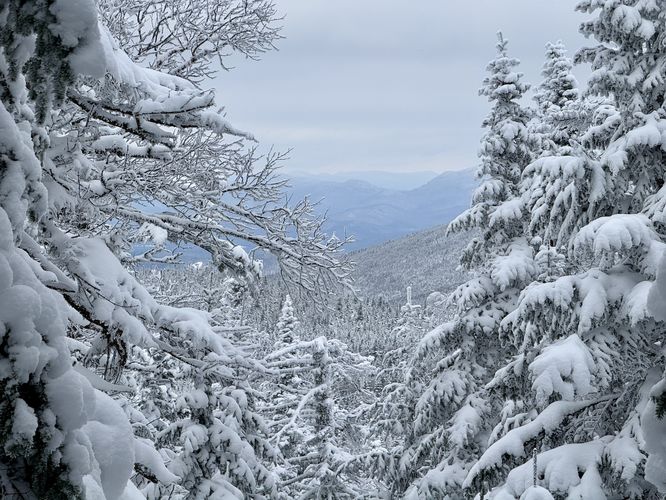
From Indian Falls, the trail leads southward following the blue blazes of the Van Hoevenberg Trail as it ascends Mount Marcy. Right after Indian Falls, the trail follows a fairly easy grade as it leads to the next steep uphill section, which begins around mile 5.3. This steep section of trail has some "breaks" along the way, which cannot be found in the contour lines on maps, but this pitch is not easy. It lasts until you reach another "plateau" around mile 5.68 where the trail begins to follow a ridge line up toward Little Marcy Mountain. Between miles 5.8 and 5.9 are several on-trail views between the trees -- or otherwise known as "windows". These small views include mountain peaks to the north and are some of the best views along the trail, assuming Mt. Marcy is sitting in the clouds (like during my hike here). This section of trail also has more uphill hiking before "easier" grades present themselves as you approach Little Marcy near the Hopkins Trail junction (mile 6.15). After passing the Hopkins Trail junction, the trail begins to ascend the last long pitch to reach the summit of Mt. Marcy. At 6.52, hikers will enter the alpine zone where extreme weather can occur -- only experienced hikers with the proper gear should continue beyond this point. Hikers will pass along the slopes of Little Marcy around mile 6.55 before the elevation grade become much steeper. If you turn around, you'll likely find some decent views from this part of the trail especially if Mt. Marcy is not in the clouds. Around mile 6.73, you'll pass the junction with the Phelps Trail.Last Push to Mt. Marcy Summit - Mile 6.73 to 7.3
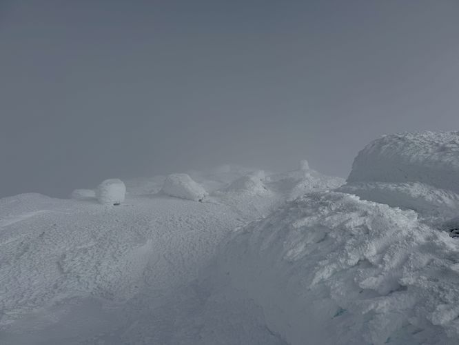
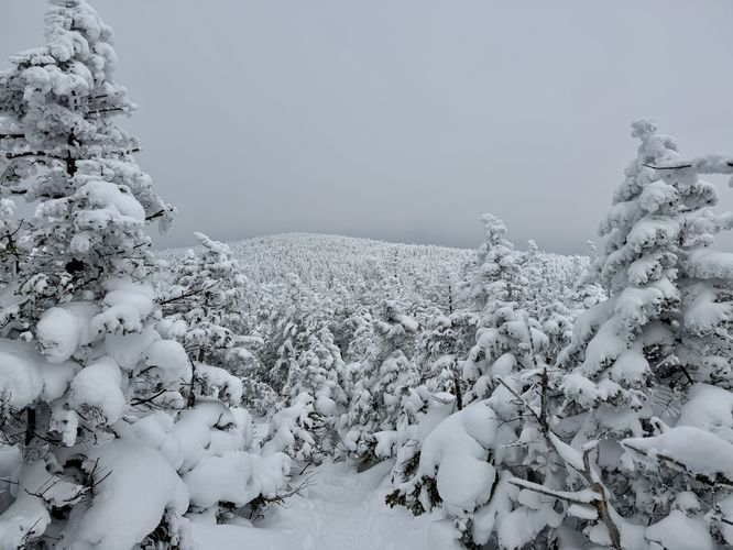
After passing the Phelps Trail junction, hikers will be on the very last push to reach the summit of Mount Marcy. This last ascent, during the winter, can be tough as it's difficult to locate the trail within the wind-drifted snowpack. During the summer, it should be pretty obvious where you can or cannot hike. This write-up focused on the winter experience since that's when I hiked this. On the way up, you'll find trees buried in snowpack, so watch out for spruce traps as the tops of spruce trees can cause you to tumble or fall into them. The trail ascends at a moderate grade, but after 3,000+ feet of elevation gain, it's a tough climb to the top. You'll know you're reaching the summit once you start to pass large stone cairns. During the winter, however, the wind speed and temperature can be extreme so make sure you bring the proper gear including ski goggles, a down jacket, and other protective equipment. Finally, around mile 7.3 hikers will reach the very top of Mt. Marcy where you'll find a plaque installed on a short cliff, marking Mt. Marcy's first written-recorded ascent (by white settlers) in 1837, installed in 1937. If you wish, you can walk atop the short cliff here, marking the very top of Mt. Marcy and New York State's highest point. During my hike here in January 2025, the very top of the mountain was enshrouded in clouds which made for no views, strong winds, and sub-zero temperatures. Despite the lack of views, the experience summitting New York's highest mountain was an accomplishment I never really thought I'd ever complete.Hiking Out - Mile 7.3 to 14.5
The hike down from the summit of Mount Marcy is straight forward, but not easy. During the winter, the first thing to note is that it's very difficult to follow the trail, due to wind-swept snow drift. Given a short period of time, your own snowshoe tracks might become covered from the way up to the start of your hike down -- so it's best to follow an offline map like the MyHikes app or others, if you need one. Make sure to pay attention to where you're going, especially if visibility is low during the winter. During warm months, this is less of an issue if not an issue at all. Second, on your descent, you'll have more time to take-in views of the surrounding mountains as you come down from the top of Mt. Marcy. Most of the views will be found at the top and end neat the Phelps Trail junction. During the winter, the bows of trees may be covered in snow and bent, providing distant views between the trees -- especially near where you passed earlier at mile 5.8, which are now found around mile 8.7. The downhill sections of trail are not too difficult, but they get old fast. Before you hike down along Phelps Brook, you might want to check out the top of Indian Falls once again, like in this route, to take-in more views before the hike is over -- you'll reach the top of Indian Falls once again around mile 10.1. The hike along Phelps Brook is fairly easy, but there are plenty of rocks and skinny footbridges that span muddy (or icy) spots. Once you reach the Marcy Dam Backcountry Campsite area, you're almost out. Be sure to checkout the views of Mount Colden and Wright Peak by the Marcy Dam before following the forested trail of the Van Hoevenberg Trail back to parking. Note that this route includes extra mileage by heading to the top of Marcy Dam (east) before crossing below the dam, using the frozen snowpack, instead of the footbridge -- hence the slightly-odd route provided. The last section of the hike is the short uphill climb back to parking at the Loj, which completes this 14.5-mile out-and-back hike to summit Mount Marcy.Parking & Fees
Hikers will find a massive parking lot at the coordinates provided at the Adirondack Mountain Club. The parking lots are large enough to fit many dozens of vehicles. As of January 2025, there's a $18 daily fee to park at the Adirondack Mountain Club's parking lot. Pets
Dogs are allowed only if leashed and must be cleaned up after.Warnings
Snowshoes: During the winter, snowshoes are required by law if the snowpack is deeper than 8-inches.Winter spindrifts and wind loading: During winter, this trail may have spindrifts where wind loading has piled up unstructured snow piles located on very steep terrain if the wind has been blowing hard or just after a heavy snowfall with fast winds.
Winter spruce traps: Along the last push to the summit, the snow pack can be extremely deep (sometimes over 6-feet), thus it buries the spruce trees that grow there. Due to this, if you accidentally step on the top of a tree, you may fall into the loosely-packed snow that surrounds it, causing you to fall over and get your snowshoes to get stuck in the branches. It's best to try and stay on the packed-in snowshoe trail for this reason.