Algonquin, Boundary, and Iroquois Peaks at Adirondack Park within the High Peaks Wilderness in North Elba, New York is a strenuous 10.5-mile out-and-back hike that runs along the MacIntyre Mountain Range, featuring a summit of Algonquin Peak - New York's second-tallest mountain - and features stunning views of the Adirondacks.
Hike Description
This hike begins at the main parking area located next to the High Peaks Information Center, following the yellow-blazed Van Hoevenberg Trail. Hikers should sign-in at the kiosk to state where you're going and how long you plan to stay.
Trail Junctions - Mile 0 to 0.75
After the trailhead kiosk, hikers will pass the Mr. Van Trail at mile 0.1, Southeast Corner Bypass Trail at mile 0.4, and finally the Fangorn Forest Trail at mile 0.75. Along the way, you'll cross a wooden bridge that spans the MacIntyre Brook, which provides some nice views of Wright Peak. Despite the easy elevation grade for the first 1.5-miles, hikers will slowly undulate their way up the base of the mountain.
Algonquin Trail - Mile 1
At mile 1, hikers will reach a well-marked trail junction with signage pointing straight for Algonquin Peak and Wright Peak.
Trail Junctions - Mile 1.45 to 1.55
Between miles 1.45 and 1.55, hikers will first keep left to stay on the Algonquin Trail and then keep right - following the yellow blazes as they lead up the mountain. From here, the hiking becomes more difficult as the elevation grade begins to get steeper over time. There are several ski trails that connect in to this trail on the way up the mountain too.
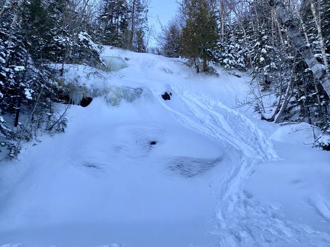
MacIntyre Falls - Mile 2.6
At mile 2.6, hikers will reach a 40-foot waterfall, MacIntyre Falls. During the Winter, this large waterfall is completely frozen over and generally looks like a steep snow-covered hillside with large ice chunks mixed in. After visiting MacIntyre Falls, the terrain become a bit more steep as the trail makes its way to a rock scramble (or ice scramble, depending on the time of year), located in a ravine.
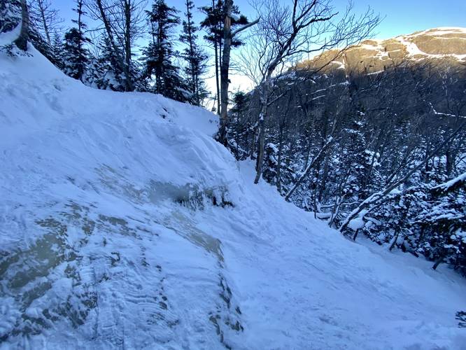
Mountain Rock Ledge - Mile 3.15
Around mile 3.15, hikers will reach a bench in the mountain (flat grade) where massive bedrock juts out of the ground to the northwest, placing the hiker in somewhat of a ravine between the rock ledge and Wright Peak. Here, the trail skirts up a steep hillside - during the winter, this rocky terrain can be very sketchy due to the steep 8 to 10-foot drop. During one hike to Wright Peak in January 2022, this was completely snow-covered with a very steep skinny path that lead up. Upon this trek in mid-March 2023, there was no snow but rather a massive ice block. Here, I snowshoed up the ice, almost losing my balance. On the way down, I cramponed and held an ice axe just in case I fell. I note this because if you try for a Winter ascent, you may run into similar conditions. Just beyond this area, again during the Winter, is where snow can pile-up from the wind, causing a large 6-foot deep snow drift. This snow drift can be dangerous and can easily break loose with enough force - causing the hiker to trigger a micro avalanche, sending them down a steep slope into some gnarly pines.
Wright Peak Junction - Mile 3.35
Around mile 3.35, hikers will reach the junction with Wright Peak - stay straight along the Algonquin Trail. From here on out, the hiking becomes even harder as the slopes of Algonquin Peak are even more difficult than the ascent up to the Wright Peak junction.
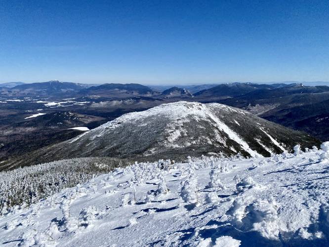
Views Begin - Mile 3.6
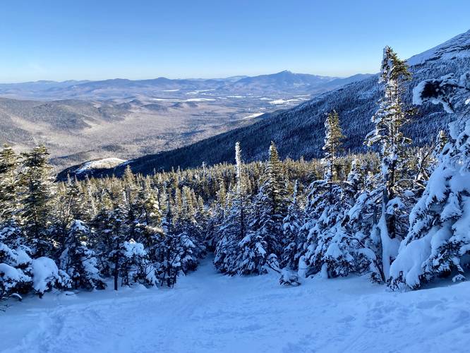
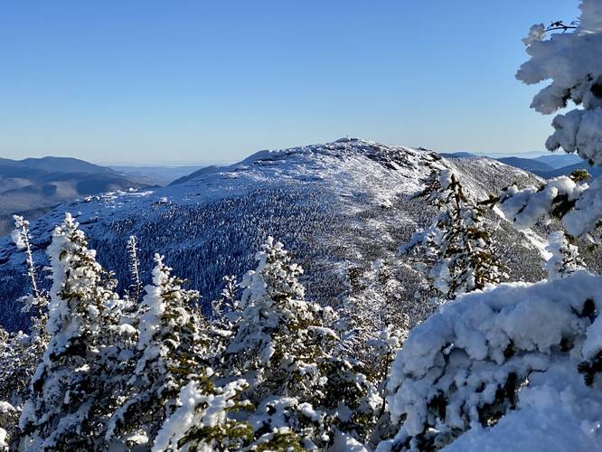
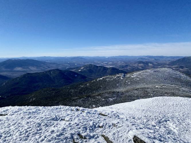
At mile 3.6, hikers will begin to get views of the neighboring Wright Peak and glimpses of Whiteface Mountain in the distance. The views are a nice change of pace as the climb from mile 3.35 to mile 4.1 are the most difficult in the entire hike. Also, the views don't stop once you hit mile 3.6, they only get better from there on out.
Algonquin Peak Alpine - Mile 3.9
At mile 3.9, hikers will reach the bedrock of Algonquin Peak. During the Winter, the bedrock and rock cairn trail markers are generally snow-covered, which makes it a bit more challenging to find your way; however, on exposed bedrock, you can generally hike where you want as long as you mind the rare alpine plants.
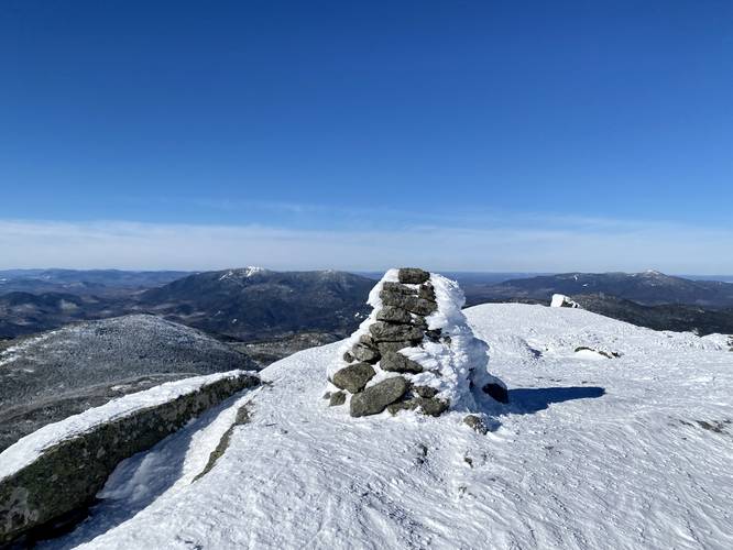
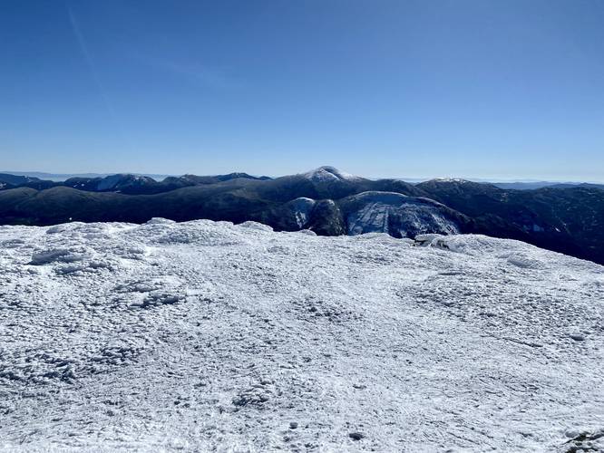
Algonquin Peak Summit - Mile 4.2
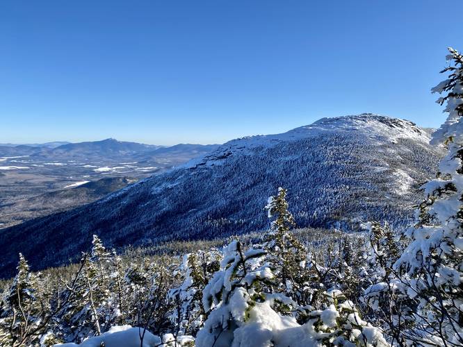
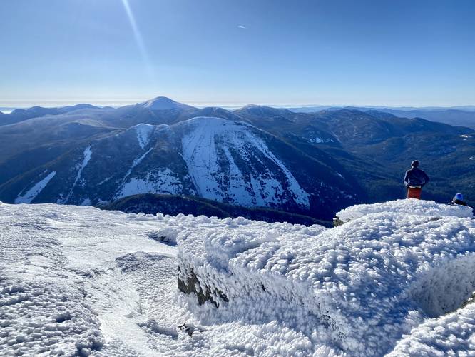
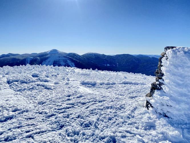
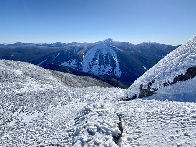
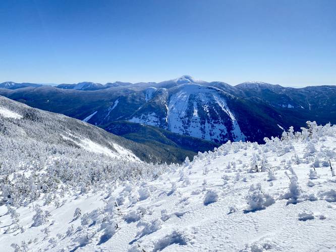
Around mile 4.2, hikers will reach the summit of Algonquin Peak - New York State's 2nd tallest mountain - which sits at 5,114-feet above sea level. Since Algonquin Peak has a large broad summit, hikers will want to explore the top of the mountain to get better views of the surrounding vistas - including Mt. Colden with its beautiful slides and Mt. Marcy (New York State's tallest mountain) sitting just behind Colden in the distance. To the North, keen-eyed hikers may spot Hurricane Mountain's fire tower, Cascade Mountain, Pitchoff Mountain, Mount Jo, Heart Lake, obviously Wright Peak, and other points of interest below. To the southwest, you'll get views of the MacIntyre Mountain Range including Boundary Peak and Iroquois Peak sitting below your feet with Wallface Mountain off to the side. Take in the views, eat a snack, and prepare for more elevation gain hiking to Boundary and Iroquois Peaks.
Algonquin Peak to Boundary Peak - Mile 4.3 to 4.85
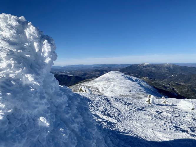
The hike down from Algonquin Peak is steep, but it doesn't last for too long - additionally, the trail follows a bit more switchbacks than the trail heading up Algonquin from the North. During the Winter, the trail may have even more switchbacks, depending on who broke trail first. Once in the col / saddle between both peaks, hikers get a unique view of Mt. Colden and Mt. Marcy once again - during Winter months - from above the spruce trees. Not sure if you get a view here during the Summer as the Winter snowpack might be over 6-feet deep. Just before the saddle, there's a trail junction - stay right and do not follow the "arrow" trail sign as it leads down the mountain instead of up Boundary Peak. The hike up Boundary Peak is initially steep, but does not last long. Hikers will reach Boundary Peak summit at mile 4.85, which sits at 4,829-feet above sea level. From Boundary Peak's summit, hikers get similar views of the surrounding mountains provided from Algonquin Peak, but from a different perspective.
Boundary Peak to Iroquois Peak - Mile 4.85 to 5.25
The col / saddle between Boundary Peak and Iroquois Peak is similar to the previous with the exception that there's a small hidden hill in the middle with a bedrock outcropping that provides another vista of the same mountain you just saw. Once on Iroquois Peak's slopes, the trail becomes very steep once again as you make your way up the last peak in this trek to reach the summit, passing several large rocky ledges along the way. Hikers will reach the summit of Iroquois Peak around mile 5.25, which sits at 4,840-feet above sea level and also marks the final unique peak along this trail. You can hike further than the summit to further views of the surrounding mountains to enjoy the views, eat a snack, or just take a break.
Last Climbs - Mile 5.3 to 6.3
After visiting Iroquois, the hike back is not easy because you have to ascend another 700+ feet to reach the top of Algonquin Peak once more. Enjoy the hike back through both cols / saddles and take the Algonquin ascent slow. During this quiet Winter hike, I was lucky enough to catch all three summits completely alone, with only visiting Algonquin once with just two other hikers on top at the time - making for this difficult hike well worth it.
Hiking Down
After exploring Algonquin Peak one last time, the hike down takes quite a while - a couple of hours to be precise. The only thing to take note of on the way down is the 8 to 10-foot tall rock scramble or ice scramble during the Winter, located around mile 7.4 on the way out, which might require cramponing down if presented with thick ice. Once you reach the base of the mountain, the elevation gain still is not over as the trail undulates its way back to parking. By the time you're done you will have climbed over 4,300-feet in elevation gain and loss. Remember to sign-out at the kiosk before leaving.
Pets
Dogs are allowed if leashed and their waste must be carried out by the hiker.
Parking and Fees
There's a very large parking lot, with several other large parking lots, located at the coordinates provided. There's a parking fee as of late January 2023: ADK-Members: $7/day. Non-members: $15/day.
Popularity
During the Summer, this hike is one of the more popular day hikes within Adirondack Park and the High Peaks Wilderness. Expect plenty of foot traffic, especially during warmer months. During the Winter, on a good day, there might be 50 people on the trail and half of those are backcountry skiers. On a bad day, very few people are on the trail during the Winter.
Winter Ascent
Note that this write-up was based on a Winter traverse and thus some of the conditions on the trail will be different for warmer seasons. During Winter, snowshoes are required by law in the High Peaks Wilderness if the snowpack is over 8-inches deep. The Adirondack Mountains can be finicky and thus you need to be properly geared if attempting Winter ascents. Proper gear includes at the very least waterproof boots, warm pants with waterproof lining near the bottom, boot gaitors, snowshoes, ice spikes, crampons (optional), ice axe (optional), down jacket, layers, ski goggles, a waterproof shell, winter hat or hood, and at least 2 liters of water. Emergency gear like extra snacks, a mylar blanket, lighter, water filter, extra socks, and a way to melt snow like a small stove can be useful to carry just in case something unexpected happens.
Warnings
Steep terrain: This hike follows some very steep terrain. Proper footwear and trekking poles are a must for this hike.
Wind speeds: The wind may become extreme above the tree line depending on the weather conditions. Also note that the weather can change here faster than it does in the valleys.
Snowshoes: During the Winter months, snowshoes are required by law if the snowpack is deeper than 8-inches.
Winter spindrifts and wind loading: This trail may have spindrifts where wind loading has piled up unstructured snow piles located on very steep terrain if the wind has been blowing hard or just after a heavy snowfall with fast winds. These snowdrifts can break away in a mini-avalanche, sending the hiker falling with it. While they're fairly small, you do not want to trigger a slide or get trapped in one, especially on very steep terrain. Note that upon my hike to Wright Peak in 2022, I triggered a small wind-loaded section of trail just above the rock/ice scramble in the Wright Peak ravine; however, during this hike in late March 2023 the trail was completely broken-in with no wind-loaded sections thankfully, so the conditions may vary during the Winter.
Winter spruce traps: In the mountain cols / saddles located beyond Algonquin Peak, the snow pack becomes extremely deep (generally over 6-feet), thus buries the spruce trees that grow there. Due to this, if you accidentally step on the top of a tree, you may fall into the loosely-packed snow that surrounds it, causing you to fall over and get your snowshoes to get stuck in the branches. It's best to try and stay on the packed-in snowshoe trail for this reason.
Time to Hike
I hiked this fairly quickly in just about 6 hours and 45 minutes from 6:30AM to ~1:15PM; however, the average hiker may take longer than this especially during warm months with no snow on the ground. Snow pack in the Winter tends to make traveling certain terrain easier as you don't have to deal with large step-like rocks.
Hike Description
This hike begins at the main parking area located next to the High Peaks Information Center, following the yellow-blazed Van Hoevenberg Trail. Hikers should sign-in at the kiosk to state where you're going and how long you plan to stay.
Trail Junctions - Mile 0 to 0.75
After the trailhead kiosk, hikers will pass the Mr. Van Trail at mile 0.1, Southeast Corner Bypass Trail at mile 0.4, and finally the Fangorn Forest Trail at mile 0.75. Along the way, you'll cross a wooden bridge that spans the MacIntyre Brook, which provides some nice views of Wright Peak. Despite the easy elevation grade for the first 1.5-miles, hikers will slowly undulate their way up the base of the mountain.
Algonquin Trail - Mile 1
At mile 1, hikers will reach a well-marked trail junction with signage pointing straight for Algonquin Peak and Wright Peak.
Trail Junctions - Mile 1.45 to 1.55
Between miles 1.45 and 1.55, hikers will first keep left to stay on the Algonquin Trail and then keep right - following the yellow blazes as they lead up the mountain. From here, the hiking becomes more difficult as the elevation grade begins to get steeper over time. There are several ski trails that connect in to this trail on the way up the mountain too.
MacIntyre Falls - Mile 2.6
At mile 2.6, hikers will reach a 40-foot waterfall, MacIntyre Falls. During the Winter, this large waterfall is completely frozen over and generally looks like a steep snow-covered hillside with large ice chunks mixed in. After visiting MacIntyre Falls, the terrain become a bit more steep as the trail makes its way to a rock scramble (or ice scramble, depending on the time of year), located in a ravine.
Mountain Rock Ledge - Mile 3.15
Around mile 3.15, hikers will reach a bench in the mountain (flat grade) where massive bedrock juts out of the ground to the northwest, placing the hiker in somewhat of a ravine between the rock ledge and Wright Peak. Here, the trail skirts up a steep hillside - during the winter, this rocky terrain can be very sketchy due to the steep 8 to 10-foot drop. During one hike to Wright Peak in January 2022, this was completely snow-covered with a very steep skinny path that lead up. Upon this trek in mid-March 2023, there was no snow but rather a massive ice block. Here, I snowshoed up the ice, almost losing my balance. On the way down, I cramponed and held an ice axe just in case I fell. I note this because if you try for a Winter ascent, you may run into similar conditions. Just beyond this area, again during the Winter, is where snow can pile-up from the wind, causing a large 6-foot deep snow drift. This snow drift can be dangerous and can easily break loose with enough force - causing the hiker to trigger a micro avalanche, sending them down a steep slope into some gnarly pines.
Wright Peak Junction - Mile 3.35
Around mile 3.35, hikers will reach the junction with Wright Peak - stay straight along the Algonquin Trail. From here on out, the hiking becomes even harder as the slopes of Algonquin Peak are even more difficult than the ascent up to the Wright Peak junction.
Views Begin - Mile 3.6
At mile 3.6, hikers will begin to get views of the neighboring Wright Peak and glimpses of Whiteface Mountain in the distance. The views are a nice change of pace as the climb from mile 3.35 to mile 4.1 are the most difficult in the entire hike. Also, the views don't stop once you hit mile 3.6, they only get better from there on out.
Algonquin Peak Alpine - Mile 3.9
At mile 3.9, hikers will reach the bedrock of Algonquin Peak. During the Winter, the bedrock and rock cairn trail markers are generally snow-covered, which makes it a bit more challenging to find your way; however, on exposed bedrock, you can generally hike where you want as long as you mind the rare alpine plants.
Algonquin Peak Summit - Mile 4.2
Around mile 4.2, hikers will reach the summit of Algonquin Peak - New York State's 2nd tallest mountain - which sits at 5,114-feet above sea level. Since Algonquin Peak has a large broad summit, hikers will want to explore the top of the mountain to get better views of the surrounding vistas - including Mt. Colden with its beautiful slides and Mt. Marcy (New York State's tallest mountain) sitting just behind Colden in the distance. To the North, keen-eyed hikers may spot Hurricane Mountain's fire tower, Cascade Mountain, Pitchoff Mountain, Mount Jo, Heart Lake, obviously Wright Peak, and other points of interest below. To the southwest, you'll get views of the MacIntyre Mountain Range including Boundary Peak and Iroquois Peak sitting below your feet with Wallface Mountain off to the side. Take in the views, eat a snack, and prepare for more elevation gain hiking to Boundary and Iroquois Peaks.
Algonquin Peak to Boundary Peak - Mile 4.3 to 4.85
The hike down from Algonquin Peak is steep, but it doesn't last for too long - additionally, the trail follows a bit more switchbacks than the trail heading up Algonquin from the North. During the Winter, the trail may have even more switchbacks, depending on who broke trail first. Once in the col / saddle between both peaks, hikers get a unique view of Mt. Colden and Mt. Marcy once again - during Winter months - from above the spruce trees. Not sure if you get a view here during the Summer as the Winter snowpack might be over 6-feet deep. Just before the saddle, there's a trail junction - stay right and do not follow the "arrow" trail sign as it leads down the mountain instead of up Boundary Peak. The hike up Boundary Peak is initially steep, but does not last long. Hikers will reach Boundary Peak summit at mile 4.85, which sits at 4,829-feet above sea level. From Boundary Peak's summit, hikers get similar views of the surrounding mountains provided from Algonquin Peak, but from a different perspective.
Boundary Peak to Iroquois Peak - Mile 4.85 to 5.25
The col / saddle between Boundary Peak and Iroquois Peak is similar to the previous with the exception that there's a small hidden hill in the middle with a bedrock outcropping that provides another vista of the same mountain you just saw. Once on Iroquois Peak's slopes, the trail becomes very steep once again as you make your way up the last peak in this trek to reach the summit, passing several large rocky ledges along the way. Hikers will reach the summit of Iroquois Peak around mile 5.25, which sits at 4,840-feet above sea level and also marks the final unique peak along this trail. You can hike further than the summit to further views of the surrounding mountains to enjoy the views, eat a snack, or just take a break.
Last Climbs - Mile 5.3 to 6.3
After visiting Iroquois, the hike back is not easy because you have to ascend another 700+ feet to reach the top of Algonquin Peak once more. Enjoy the hike back through both cols / saddles and take the Algonquin ascent slow. During this quiet Winter hike, I was lucky enough to catch all three summits completely alone, with only visiting Algonquin once with just two other hikers on top at the time - making for this difficult hike well worth it.
Hiking Down
After exploring Algonquin Peak one last time, the hike down takes quite a while - a couple of hours to be precise. The only thing to take note of on the way down is the 8 to 10-foot tall rock scramble or ice scramble during the Winter, located around mile 7.4 on the way out, which might require cramponing down if presented with thick ice. Once you reach the base of the mountain, the elevation gain still is not over as the trail undulates its way back to parking. By the time you're done you will have climbed over 4,300-feet in elevation gain and loss. Remember to sign-out at the kiosk before leaving.
Pets
Dogs are allowed if leashed and their waste must be carried out by the hiker.
Parking and Fees
There's a very large parking lot, with several other large parking lots, located at the coordinates provided. There's a parking fee as of late January 2023: ADK-Members: $7/day. Non-members: $15/day.
Popularity
During the Summer, this hike is one of the more popular day hikes within Adirondack Park and the High Peaks Wilderness. Expect plenty of foot traffic, especially during warmer months. During the Winter, on a good day, there might be 50 people on the trail and half of those are backcountry skiers. On a bad day, very few people are on the trail during the Winter.
Winter Ascent
Note that this write-up was based on a Winter traverse and thus some of the conditions on the trail will be different for warmer seasons. During Winter, snowshoes are required by law in the High Peaks Wilderness if the snowpack is over 8-inches deep. The Adirondack Mountains can be finicky and thus you need to be properly geared if attempting Winter ascents. Proper gear includes at the very least waterproof boots, warm pants with waterproof lining near the bottom, boot gaitors, snowshoes, ice spikes, crampons (optional), ice axe (optional), down jacket, layers, ski goggles, a waterproof shell, winter hat or hood, and at least 2 liters of water. Emergency gear like extra snacks, a mylar blanket, lighter, water filter, extra socks, and a way to melt snow like a small stove can be useful to carry just in case something unexpected happens.
Warnings
Steep terrain: This hike follows some very steep terrain. Proper footwear and trekking poles are a must for this hike.
Wind speeds: The wind may become extreme above the tree line depending on the weather conditions. Also note that the weather can change here faster than it does in the valleys.
Snowshoes: During the Winter months, snowshoes are required by law if the snowpack is deeper than 8-inches.
Winter spindrifts and wind loading: This trail may have spindrifts where wind loading has piled up unstructured snow piles located on very steep terrain if the wind has been blowing hard or just after a heavy snowfall with fast winds. These snowdrifts can break away in a mini-avalanche, sending the hiker falling with it. While they're fairly small, you do not want to trigger a slide or get trapped in one, especially on very steep terrain. Note that upon my hike to Wright Peak in 2022, I triggered a small wind-loaded section of trail just above the rock/ice scramble in the Wright Peak ravine; however, during this hike in late March 2023 the trail was completely broken-in with no wind-loaded sections thankfully, so the conditions may vary during the Winter.
Winter spruce traps: In the mountain cols / saddles located beyond Algonquin Peak, the snow pack becomes extremely deep (generally over 6-feet), thus buries the spruce trees that grow there. Due to this, if you accidentally step on the top of a tree, you may fall into the loosely-packed snow that surrounds it, causing you to fall over and get your snowshoes to get stuck in the branches. It's best to try and stay on the packed-in snowshoe trail for this reason.
Time to Hike
I hiked this fairly quickly in just about 6 hours and 45 minutes from 6:30AM to ~1:15PM; however, the average hiker may take longer than this especially during warm months with no snow on the ground. Snow pack in the Winter tends to make traveling certain terrain easier as you don't have to deal with large step-like rocks.