The Alander Mountain Trail is a 6.1 mile out-and-back hike up to the summit of Alander Mountain in Mount Washington, Massachusetts. This trail is great for a one or two night backpacking trip and one of the best backpacking trails in the Berkshire Mountains.
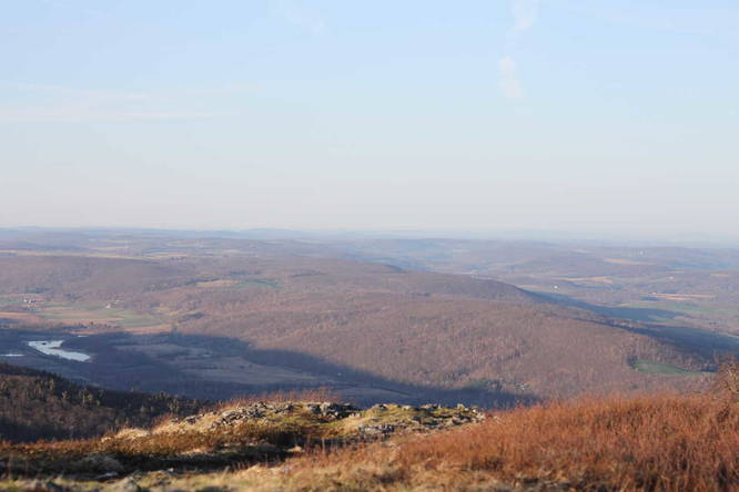
Alander Mountain is located in the southwest corner of Massachusetts and lies on the New York and Connecticut borders. From the summit of Alander Mountain, you can see the Catskill Mountains and other features in New York state. There are also views to the south into Connecticut. If you hike north from the summit, you can get an almost 360 degree view of the Berkshires and surrounding states.
Trail Description
The Alander Mountain Trail begins at the main parking lot. There's a sign-in board where hikers and backpackers can check-in. It's required that backpackers check-in, but day hikers should check-in regardless in case something happens out on the trail.
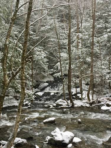
The trail immediately begins by passing an open field with views of a small pond just off of the trail. It then heads into the woods and follows a mostly-coniferous forest until the trail heads downhill. The first downhill section leads to the first creek crossing, where the state forest built a 'new' bridge circa 2014. Hikers and backpackers can use this creek to filter water if they please.
Continuing onward, the trail leads back uphill and passes two trail junctions before heading downhill once again. Hikers should stay right at each trail junction to continue on the Alander Mountain Trail.
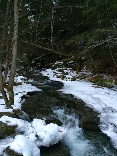
After the second trail junction, which is more of a trail fork, the trail heads down another fairly steep hill to another creek crossing with a 'newly'-built (circa 2014) bridge. Here, hikers can find a short fan-tail waterfall that cascades down an adjacent creek and is no more than 4-feet tall or so.
From this bridge crossing the trail is technically sitting at the lowest elevation throughout the whole hike and it begins its ascent up Mt. Alander. The campground spur trail is not too far from this creek crossing, maybe about 0.75-miles from this point.
It's not until hikers reach the 2nd-mile marker where the trail begins a steep ascent up to the summit of Mt. Alander. This section of the trail is certainly harder and slows most people down - whether you're hiking up or hiking down the mountain, take your time along this section of the trail.
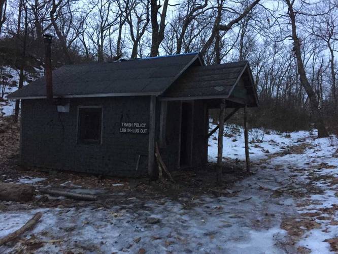
Just before reaching the summit, the trail will level out and reach a small first-come, first-serve cabin that backpackers can use freely. Take the trail that sits directly across from the cabin's front door and follow it up to the actual summit of Mt. Alander for beautiful views of the surrounding area.
Pets
Dogs are allowed if leashed and their waste must be carried out by the hiker.
Parking
Hikers can find parking at the coordinates provided. The address provided is an approximate address, but the coordinates are much more precise.
Backcountry Camping Closed, 2023
According to the Mt Washington State Forest Website, backcountry / dispersed / primitive camping is not allowed for the time being. It's unclear when that rule will be lifted. Please check their site before planning an overnight here as things have changed over the years.
Camping Near the Summit (Cabin)
There's a small, free, first-come first-served cabin near the summit with a stove and 4 bunks. There are streams on the way up the mountain that you can use to filter water as well, but there's no reliable water source near the cabin itself.
Campground Along the Trail
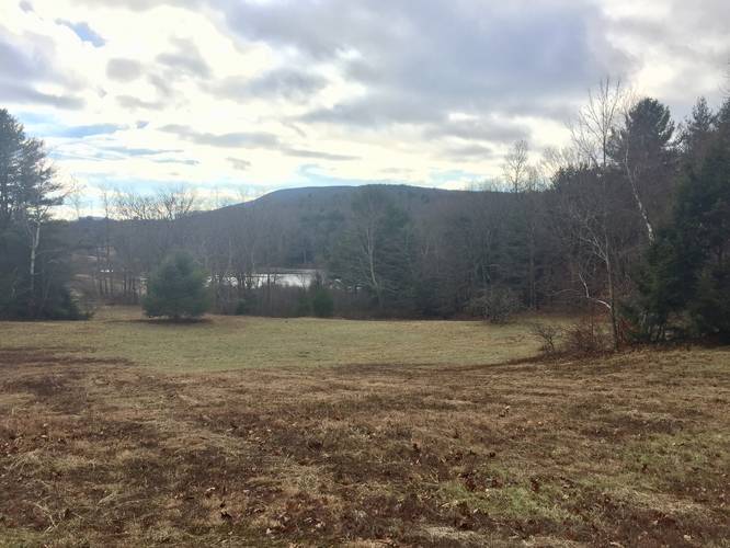
There's a campground situated half way up the mountain (about 1.5-miles from the parking lot trailhead) with signs along the trail pointing to the campground's spur trail. Each site is first-come first-serve, free, and they usually sit about 50 feet away from each other. Some sites are more secluded than others.
Bash Bish Falls
A section of the South Taconic Trail, at the summit of Mt Alander, leads north to Bash Bish Falls and Bash Bish Mountain, which is about 3 miles away from the summit. The trail down to Bash Bish Falls is very steep as the entire hike out there runs along the ridge of the mountain range and then suddenly drops down to Bash Bish Brook. The hike back to Alander is strenuous, so plan to bring plenty of water.
Alander Mountain is located in the southwest corner of Massachusetts and lies on the New York and Connecticut borders. From the summit of Alander Mountain, you can see the Catskill Mountains and other features in New York state. There are also views to the south into Connecticut. If you hike north from the summit, you can get an almost 360 degree view of the Berkshires and surrounding states.
Trail Description
The Alander Mountain Trail begins at the main parking lot. There's a sign-in board where hikers and backpackers can check-in. It's required that backpackers check-in, but day hikers should check-in regardless in case something happens out on the trail.
The trail immediately begins by passing an open field with views of a small pond just off of the trail. It then heads into the woods and follows a mostly-coniferous forest until the trail heads downhill. The first downhill section leads to the first creek crossing, where the state forest built a 'new' bridge circa 2014. Hikers and backpackers can use this creek to filter water if they please.
Continuing onward, the trail leads back uphill and passes two trail junctions before heading downhill once again. Hikers should stay right at each trail junction to continue on the Alander Mountain Trail.
After the second trail junction, which is more of a trail fork, the trail heads down another fairly steep hill to another creek crossing with a 'newly'-built (circa 2014) bridge. Here, hikers can find a short fan-tail waterfall that cascades down an adjacent creek and is no more than 4-feet tall or so.
From this bridge crossing the trail is technically sitting at the lowest elevation throughout the whole hike and it begins its ascent up Mt. Alander. The campground spur trail is not too far from this creek crossing, maybe about 0.75-miles from this point.
It's not until hikers reach the 2nd-mile marker where the trail begins a steep ascent up to the summit of Mt. Alander. This section of the trail is certainly harder and slows most people down - whether you're hiking up or hiking down the mountain, take your time along this section of the trail.
Just before reaching the summit, the trail will level out and reach a small first-come, first-serve cabin that backpackers can use freely. Take the trail that sits directly across from the cabin's front door and follow it up to the actual summit of Mt. Alander for beautiful views of the surrounding area.
Pets
Dogs are allowed if leashed and their waste must be carried out by the hiker.
Parking
Hikers can find parking at the coordinates provided. The address provided is an approximate address, but the coordinates are much more precise.
Backcountry Camping Closed, 2023
According to the Mt Washington State Forest Website, backcountry / dispersed / primitive camping is not allowed for the time being. It's unclear when that rule will be lifted. Please check their site before planning an overnight here as things have changed over the years.
Camping Near the Summit (Cabin)
There's a small, free, first-come first-served cabin near the summit with a stove and 4 bunks. There are streams on the way up the mountain that you can use to filter water as well, but there's no reliable water source near the cabin itself.
Campground Along the Trail
There's a campground situated half way up the mountain (about 1.5-miles from the parking lot trailhead) with signs along the trail pointing to the campground's spur trail. Each site is first-come first-serve, free, and they usually sit about 50 feet away from each other. Some sites are more secluded than others.
Bash Bish Falls
A section of the South Taconic Trail, at the summit of Mt Alander, leads north to Bash Bish Falls and Bash Bish Mountain, which is about 3 miles away from the summit. The trail down to Bash Bish Falls is very steep as the entire hike out there runs along the ridge of the mountain range and then suddenly drops down to Bash Bish Brook. The hike back to Alander is strenuous, so plan to bring plenty of water.