Loading...

Distance:
2.0 Miles
Type:
Out-and-Back
Difficulty:
Moderate
Time to Hike:
1 hour
Features:
Surface Type:
Dirt
Park:
Bash Bish Falls State Park
Town:
Mount Washington, Massachusetts
Directions:
42.115136, -73.491421
5
Added:
March 06, 2018
Updated:
March 06, 2018

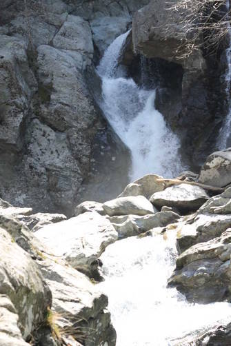
The Bash Bish Falls Trail at Bash Bish State Park in Mt Washington, Massachusetts is a moderate 2 mile out-and-back trail that leads downhill to Bash Bish Falls and follows Bash Bish Brook west. Bash Bish Falls is the highest single-drop waterfall in the state and a must-see if you're visiting the Berkshires.

There are two parking lots for this trail. The parking lot to the west, along Route 344 is an easier hike to the falls, but a longer out-and-back hike. If you park at the east lot, above the falls, you'll end up hiking down a set of stairs and then a steeper portion of the trail to get to the falls; however, it's much faster to reach the falls from the eastern lot.

If you plan to just hike to the falls, the out-and-back hike from the eastern lot is only about 0.6 miles, but it's a much more difficult hike considering the 500 foot elevation gain in just 0.3 miles.

Fishing is allowed in the brook along the trail and dogs are allowed as well.

Explore 10 trails near Mount Washington, MA

Hazards

Ticks - Lyme Disease More Info (CDC)

Seasons

All
Loading...
Loading...
514 '

Total Change
535 '

Ascent
535 '

Descent
Bash Bish Falls Trail default picture

Photo Albums

2 Trip Reports

No Star-Ratings
Trail added
March 06, 2018
Updated on
March 06, 2018
3.5 miles
June 05, 2020
Trail was good. Parking was all closed due to COVID, so we started at the bottom of the hill, walked up to the parking area and went from there up to the falls, then back down the way. Adds an extra mile or so both ways!
Hiking

Find Hiking Trails Near Me:

Map of MyHikes' trails in North America

Weather Forecast

In Mount Washington, MA
Find your quest with MyHikes

Explore Hiking Trails

New Hikes

1
Mt. Minsi via Appalachian Trail
4.7 Miles
Moderate Loop
2
Sandy Bottom Vista
1.4 Miles
Moderate Out-and-Back
Green River Overlook
0.2 Miles
Easy Out-and-Back
Price Canyon Lookout
0 Miles
Easy Out-and-Back

Before you leave...

MyHikes is an indie web platform aimed to make exploring public trails easier for everyone. The site has no investors and is owned and operated by one person, Dave Miller / Admin. As the main contributor and doer-of-all-things for MyHikes, I share my experiences from hikes and backpacking trips on MyHikes for fun on a volunteer basis and I believe that public trail information should be available to everyone.

It takes a lot of time 🕦, money 💰, and effort (including espresso shots ☕) to run MyHikes, including hiking , mapping , writing , and publishing new trails with high-quality content... along with building new features, moderating, and site maintainance . I simply ask that if you find our content helpful or useful when planning your next adventure that you consider making a small donation to help keep the site running.

You can become a Supporter* (*MyHikes user account required) to unlock perks for as little as $0.83/month with a 1-time non-recurring payment 👍 Or you can simply Donate any amount without a MyHikes user account. Otherwise, telling your friends about MyHikes is the next-best thing to a donation - both quick and free 😄

Thanks for visiting MyHikes and have a great hike! ✌

Admin user profile picture

Dave Miller
MyHikes Founder & Admin