-
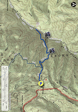
Mile 0.0 – At Mount Sterling Gap, park at pullouts on either side of Mount Sterling Rd. The Mount Sterling Trail begins on the west side of the gap. Mount Sterling Rd was a historically important connector between the remote valleys of the Great Smokies. Formerly known as the Cataloochee Turnpike, the road was completed in 1860 and was a route used by Union and Confederate soldiers during the Civil War to move between North Carolina and Tennessee.
The Mount Sterling Trail is still maintained as a service road by the national park for tower and transmission maintenance. Although it climbs 1,800 feet in 2.4 miles, the trail is not as difficult as the elevation change per mile indicates. -
Mile 0.5 – T-junction with the Long Bunk Trail on the left.
-
Mile 1.4 – Northwest view from the trail of Mount Sterling Ridge. Shortly beyond this point the trail climbs above 5,000 feet and is lined with Fraser fir and red spruce.
-
Mile 2.4 – The Mount Sterling Trail intersects the Mount Sterling Ridge Trail and Benton MacKaye Trail at a Y-junction. Turn right following the Mount Sterling Trail and Benton MacKaye Trail on the final approach to the summit through dense conifer forests.
-
Mile 2.8 – The trail passes hitching posts for horses then turns right towards the Mount Sterling lookout tower in a clearing. On the left side of the trail is backcountry campsite #38. The trail passes beside the lookout tower and continues as the Baxter Creek Trail and Benton MacKaye Trail down the mountain towards the Big Creek Campground. The 60-foot steel Aermotor lookout tower stands at the summit of Mount Sterling (5,842 feet) in a small clearing. The tower, originally built in 1935, is still actively used as a radio communications tower by the National Park Service. Until recently, a powerline provided electricity to the tower from the east side. In 2017, a solar microgrid was installed beside the tower to be self-sufficient and allow removal of the powerlines from the mountainside.
The tower and the top cab is open to the public. Almost all of the windows inside the cab remain intact, so you will get the best views from the stairs just below the cab. Mount Cammerer, home to another lookout tower, is the abrupt peak northwest across the Big Creek watershed. Due west, the tallest peak is Mount Guyot, the second tallest mountain in the national park. Mount Sterling Ridge continues southwest, culminating in Big Cataloochee Mountain. The expansive Balsam Mountain transverse chain lies behind Big Cataloochee Mountain. The Cataloochee Divide rises south above the remote Cataloochee Valley. The highest peak on the divide is Hemphill Bald, whose massive bald summit should be discernable. Further south to the left of Hemphill Bald are the Plott Balsam Mountains. In the distance southeast are the Great Balsam Mountains. The Newfound Mountains rise east above the Pigeon River. On clear days you should be able to see the dominant crest of the Black Mountains. The Bald Mountains rise north and northeast above the Pigeon River Gorge, with Max Patch the most recognizable peak in the northeast. -
Mile 3.2 – Turn left on the Mount Sterling Trail.
- Mile 5.5 – Hike ends at Mount Sterling Rd.
Mount Sterling Hike
Know Before You Go
- Distance
- 5.5 mi
- Difficulty
- Hard
- Type
- Out-and-Back
- Est. Time
- 2.7 hrs
- Elev. Gain
- 2,009'
- Rating
- 4.0
- Added
- January 23, 2025
- Updated
- April 04, 2025
Weather Forecast
Don't let Google decide who you trust.


<strong>Trail map and elevation chart not rendering in print mode?</strong> Simply scroll to the trail map section, then try printing again!
592 m
612 m
612 m
Features
- Vista / Lookout Point
- Dogs
- Mountain Summit
- Camping
Points of interest
-
Parking
35.700309, -83.097488 -
Main Trailhead
35.700174, -83.09741
Safety information
For your own safety: plan ahead, let someone know where you'll be, and hike at your own risk.
Hazards
Availability
Surface type
Trip Reports (Reviews)
Ready to help fellow hikers? Add a trip report to share your experience!


You may also like

25 Best Day Hikes in North Carolina
Discover the top 25 best day hikes in North Carolina, from breathtaking waterfalls to mountain peaks. Explore hidden gems, scenic views, and trails suitable for all skill levels, perfect for your next outdoor adventure.

Best of the Alps: Hiking, Adventure & Scenery
Plan your ultimate European Alps adventure! Discover the best hiking trails, epic scenery, and villages in the Swiss Alps, Dolomites, Chamonix, and Lake Como.

Colorado's Million Dollar Highway
Plan a day's drive adventure along the iconic Million Dollar Highway in Colorado. Explore the best short trails, roadside stops, waterfalls, vistas, ghost towns, and hot springs within a ~6 hour road trip.

Glacier's Going-to-the-Sun Road
Discover the breathtaking beauty of Glacier National Park along the iconic Going-to-the-Sun Road. From stunning roadside stops to picturesque waterfalls and vistas, this engineering marvel offers endless opportunities for exploration.

