Loading...

❄️ WINTER SALE! 50% OFF on Supporter Accounts — now through January 31st. Unlock a full year of exclusive website & app perks. Learn More.

Mount Pisgah Hike

The climb to Mount Pisgah is a classic hike on the Blue Ridge Parkway southwest of Asheville. Mount Pisgah at 5,721 feet is one of the most recognizable peaks in North Carolina with its pyramidal summit and 339-foot television transmission tower. Other than the view north, which is obscured by the tower, you have panoramic views east, south and west from the observation deck at the summit. The high points of the Great Balsam Mountains dominate the southwest-west view with Cold Mountain as the most striking peak. Although this is an extremely popular hike, Mount Pisgah is a great jumping off point to explore more of this beautiful mountain range.

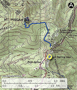
  • Mile 0.0 – Hike begins at the Buck Spring Gap Overlook. From the parking area Mount Pisgah rises above to the northwest. You also have a view east of the Big Creek basin from the overlook. Pick up the Mountains-to-Sea Trail [440] (white blaze) on the right side of the road. This connects to the Mount Pisgah Parking Area, but you can also follow the road here on the wide shoulders.

  • Mile 0.2 – MST passes through the Mount Pisgah Parking Area. The MST and Shut-In Trail [345] turn right continuing north. When you walk through the parking area you have a clear view west of Cold Mountain and of course Mount Pisgah overhead. At the far end of the parking lot begin the Mount Pisgah Trail [355]. A trail turns left heading towards the picnic area, campground, and Fryingpan Mountain. The trail at first is relatively flat as it heads towards a gap below Little Pisgah Mountain, then the real climbing begins around Mile 0.6. For the next 0.8-mi it climbs over 700 feet on countless rock steps.

  • Mile 1.4 – The trail ends at the observation deck on top of Mount Pisgah (5,721 feet). The 339-foot television transmission tower rises overhead obscuring clear views north from the deck. To the east and southeast the Hickory Nut Mountains rise above the French Broad River Valley. On a clear day you should be able to see the Great Craggy and Black Mountain ranges in the northeast direction. The communications tower and lookout tower are clearly visible south on Fryingpan Mountain. The rugged crest of the central Great Balsam Mountains spread out before you from southwest to west. Black Balsam Knob is the tall, broad peak on the left and is the second tallest peak in the range. The conical peak due west is Cold Mountain at the northern tip of the range, separated from Mount Pisgah by the East Fork of the Pigeon River.

  • Mile 2.8 – Hike ends at the Buck Spring Gap Overlook parking area.
By HikingUpward Contributor: Zach Robbins
Explore 23 trails near Mills River, NC

Know Before You Go

  • The Mount Pisgah Trail is a popular 2.8-mile hike located off the Blue Ridge Parkway near Asheville, NC, offering panoramic views from its 5,721-foot summit.
  • The trail begins at the Buck Spring Gap Overlook and involves a significant climb, with a notable section gaining over 700 feet in 0.8 miles, often on rock steps.
  • While the summit offers expansive views east, south, and west, the view north is obstructed by a 339-foot television transmission tower, but the hike provides access to explore more of the surrounding mountain range.
Interactive topographic map for Mount Pisgah Hike located in Mills River, NC. Click the "View Map" button to load GPS coordinates and trail markers.
Get directions
Distance
2.8 mi
Difficulty
Moderate
Type
Out-and-Back
Est. Time
1.4 hrs
Elev. Gain
867'
Rating
4.0
Added
March 13, 2025
Updated
April 05, 2025

Weather Forecast

Loading...
Total Change
728'
Ascent
867'
Descent
868'
Loading...

Download the GPX Data for Offline Use

Supporters get exclusive access to download trail routes to the MyHikes app for offline use. Stay prepared on your adventure, even without an internet connection! Become a Supporter today to unlock this feature and hike with confidence.

Download Mount Pisgah Hike GPX Data to the MyHikes Mobile App

Features

Vista / Lookout Point
Dogs
Mountain Summit

Points of interest

  1. Parking

    35.415368, -82.748761
  2. Main Trailhead

    35.415368, -82.748761

Safety information

For your own safety: plan ahead, let someone know where you'll be, and hike at your own risk.

Hazards

Snakes (Rattlesnakes, Copperheads, others)
Poison Ivy or Poison Oak

Markers

Blaze Color

White

Availability

All seasons

Surface type

Dirt

Trip Reports (Reviews)

Rated 4.0 out of 5 based on 1 rating.

Ready to help fellow hikers? Add a trip report to share your experience and provide valuable insights for other hikers!

By: Steve
2.8 miles / 4.5 km
November 03, 2018
This is a nice 2-hour hike with a great view from the top!The hike itself was challenging enough that you felt like you actually accomplished something while still being able to do other things that day.We picked the hike because it was close to Asheville (about 40 minutes from the Northern side where we were staying), and so obviously it was busy, but it wasn't crowded, and the people on the trail had good trail etiquette (they enjoyed hiking for the sake of hiking, and seemed capable/prepared to complete the hike ).Definitely recommended for hikers visiting Asheville wanting to scratch their itch in the middle of a busy weekend.
Legacy Review
No community routes found. To add your own hike as a Community Route for this Trail guide, leave a Trip Report with an attached GPX file.

Popular categories

Scenic mountain view representing vista trails
Vista trails
Scenic gorge of cascades representing waterfall trails
Waterfall hikes
Rugged mountain terrain representing summit trails
Summit trails
Scenic mountain view representing dog-friendly trails
Dog-friendly
Scenic campsite with a view representing camping trails
Camping trails
Appalachian Trail logo representing A.T. hikes
A.T. hikes

You May Also Like

25 Best Day Hikes in North Carolina - Discover the top 25 best day hikes in North Carolina, from breathtaking waterfalls to mountain peaks. Explore hidden gems, scenic views, and trails suitable for all skill levels, perfect for your next outdoor adventure.
Explore

25 Best Day Hikes in North Carolina

Discover the top 25 best day hikes in North Carolina, from breathtaking waterfalls to mountain peaks. Explore hidden gems, scenic views, and trails suitable for all skill levels, perfect for your next outdoor adventure.

Read
Colorado's Million Dollar Highway - Plan a day's drive adventure along the iconic Million Dollar Highway in Colorado. Explore the best short trails, roadside stops, waterfalls, vistas, ghost towns, and hot springs within a ~6 hour road trip.
Explore

Colorado's Million Dollar Highway

Plan a day's drive adventure along the iconic Million Dollar Highway in Colorado. Explore the best short trails, roadside stops, waterfalls, vistas, ghost towns, and hot springs within a ~6 hour road trip.

Read
Glacier's Going-to-the-Sun Road - Discover the breathtaking beauty of Glacier National Park along the iconic Going-to-the-Sun Road. From stunning roadside stops to picturesque waterfalls and vistas, this engineering marvel offers endless opportunities for exploration.
Explore

Glacier's Going-to-the-Sun Road

Discover the breathtaking beauty of Glacier National Park along the iconic Going-to-the-Sun Road. From stunning roadside stops to picturesque waterfalls and vistas, this engineering marvel offers endless opportunities for exploration.

Read
🍪 We use cookies to learn about site usage and to serve map tiles. You may block cookies manually in the browser. By continuing you agree. Learn more