The Mossy Cave Trail & Waterfall at Bryce Canyon National Park near Tropic, Utah is an easy 0.9-mile out-and-back hike that features a large cave that fills with Summer moss and Winter ice in addition to a beautiful ~30-foot waterfall.
Hike Description
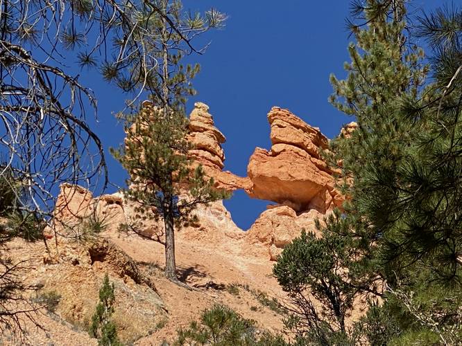
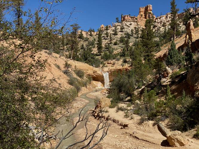
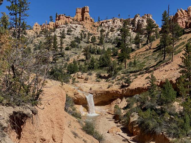
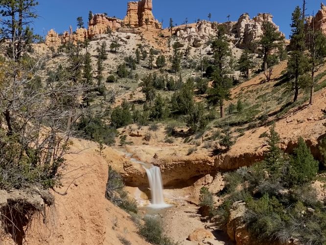
This hike begins at the main parking lot and follows the Mossy Cave Trail as it follows alongside a stream bed named the Historic Tropic Ditch Creek. Hikers will follow the trail as it leads gradually uphill - along the way, if you hike off-trail just a little bit, you'll get nice views of the creek below and the rocky cliffs of Bryce Canyon surrounding the area. There are even a couple of small arches you can spot from the trail, one named Window Arch / Little Window Arch. The trail eventually leads to a bridge, crossing the creek, where hikers will find scenic creek views both up and downstream. After crossing the bridge, hikers will head uphill for a short while before coming across another bridge where you'll get views of the 30-foot waterfall as it spills down the canyon's ledge. This waterfall, on some maps, is labeled as Tropic Ditch Falls.
Mossy Cave Benchmark - Mile 0.3
Around mile 0.3, hikers will reach a junction in the trail. Mossy Cave can be found to the left, which this GPS track heads to first. Here, you'll also find a benchmark for the Mossy Cave - a part of the "I Hiked the Hoodoos" challenge. If you also hiked the Queen's Garden & Navajo Loop, this will be your 3rd and final benchmark to discover - which apparently has a small reward from the visitors center if you bring them proof of finding all 3.
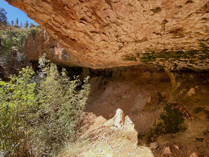
Mossy Cave - Mile 0.4
After taking a left-hand turn at the benchmark sign, around mile 0.4, hikers will reach the Mossy Cave. During the Summer, the cave is full of greenery including moss, grasses, and ferns. During the Winter, the cave is full of ice - making this a neat place to explore year-round. After exploring Mossy Cave a bit, the trail heads back to the junction and then heads straight to follow the trail as it leads to the waterfall.
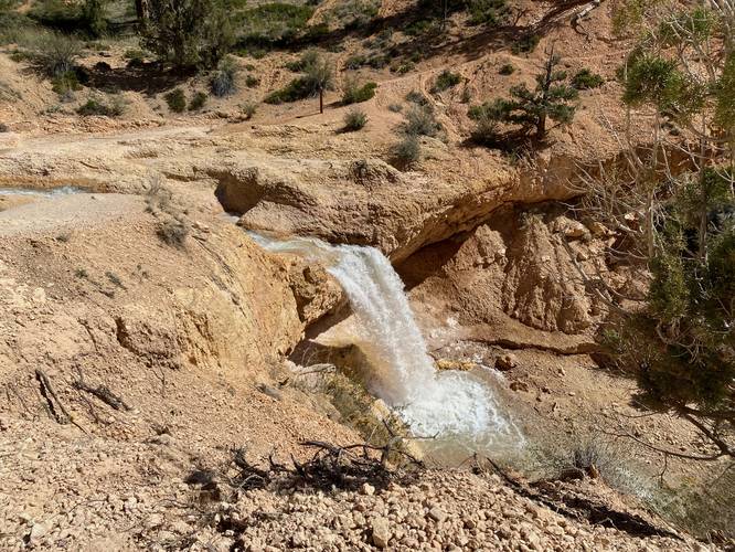
Tropic Ditch Falls / 30-foot Tall Waterfall - Mile 0.6
Around mile 0.6, hikers will reach the 30-foot tall waterfall known as Tropic Ditch Falls. This waterfall spills over the canyon's ledge to form a beautiful free-falling cascade in this otherwise desert-like section of Bryce Canyon. Hikers can walk closer to the top of the waterfall (be careful of the slick dirt-covered bedrock and steep terrain) to get a view from near the top.
After visiting both Mossy Cave, Tropic Ditch Falls, and grabbing proof of the benchmark (if you wish), the hike out is easy and mostly all downhill back to parking.
Parking
Hikers will find a smaller-sized parking lot at the coordinates provided, which is large enough to fit just over a dozen vehicles or so.
Pets
Dogs are not allowed on this trail.
History
On some maps this stream is referred to as Historic Tropic Ditch - the name might refer to a time back in 1892 when settlers built an irrigation system that diverted water from the plateau above and down into this used-to-be-seasonal creek bed. Since then the creek has flowed continuously ever since, but prior to 1892 the creek only flowed during Spring or after heavy rainfall.
Hike Description
This hike begins at the main parking lot and follows the Mossy Cave Trail as it follows alongside a stream bed named the Historic Tropic Ditch Creek. Hikers will follow the trail as it leads gradually uphill - along the way, if you hike off-trail just a little bit, you'll get nice views of the creek below and the rocky cliffs of Bryce Canyon surrounding the area. There are even a couple of small arches you can spot from the trail, one named Window Arch / Little Window Arch. The trail eventually leads to a bridge, crossing the creek, where hikers will find scenic creek views both up and downstream. After crossing the bridge, hikers will head uphill for a short while before coming across another bridge where you'll get views of the 30-foot waterfall as it spills down the canyon's ledge. This waterfall, on some maps, is labeled as Tropic Ditch Falls.
Mossy Cave Benchmark - Mile 0.3
Around mile 0.3, hikers will reach a junction in the trail. Mossy Cave can be found to the left, which this GPS track heads to first. Here, you'll also find a benchmark for the Mossy Cave - a part of the "I Hiked the Hoodoos" challenge. If you also hiked the Queen's Garden & Navajo Loop, this will be your 3rd and final benchmark to discover - which apparently has a small reward from the visitors center if you bring them proof of finding all 3.
Mossy Cave - Mile 0.4
After taking a left-hand turn at the benchmark sign, around mile 0.4, hikers will reach the Mossy Cave. During the Summer, the cave is full of greenery including moss, grasses, and ferns. During the Winter, the cave is full of ice - making this a neat place to explore year-round. After exploring Mossy Cave a bit, the trail heads back to the junction and then heads straight to follow the trail as it leads to the waterfall.
Tropic Ditch Falls / 30-foot Tall Waterfall - Mile 0.6
Around mile 0.6, hikers will reach the 30-foot tall waterfall known as Tropic Ditch Falls. This waterfall spills over the canyon's ledge to form a beautiful free-falling cascade in this otherwise desert-like section of Bryce Canyon. Hikers can walk closer to the top of the waterfall (be careful of the slick dirt-covered bedrock and steep terrain) to get a view from near the top.
After visiting both Mossy Cave, Tropic Ditch Falls, and grabbing proof of the benchmark (if you wish), the hike out is easy and mostly all downhill back to parking.
Parking
Hikers will find a smaller-sized parking lot at the coordinates provided, which is large enough to fit just over a dozen vehicles or so.
Pets
Dogs are not allowed on this trail.
History
On some maps this stream is referred to as Historic Tropic Ditch - the name might refer to a time back in 1892 when settlers built an irrigation system that diverted water from the plateau above and down into this used-to-be-seasonal creek bed. Since then the creek has flowed continuously ever since, but prior to 1892 the creek only flowed during Spring or after heavy rainfall.