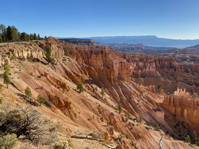
The Queen's Garden & Navajo Loop at Bryce Canyon National Park near Bryce Canyon City, Utah is a moderate 3.4-mile loop hike that features stunning up-close views of Bryce Canyon's hoodoos including the E.T., Queen Victoria, and Thor's Hammer Hoodoos.
Trails
This hike follows three named trails Rim Trail, Queen's Garden Trail, Navajo Loop. This hike follows a clockwise loop starting at Sunrise Point.
Hike Description
This hike begins at the main parking lot for Sunrise Point and follows the paved universally-accessible pathway in to reach the Rim Trail. Once at the Rim Trail, hikers will head south to reach the trailhead for the Queen's Garden Trail.
Queen's Garden Trail to E.T. Hoodoo - Mile 0.2 to 0.7
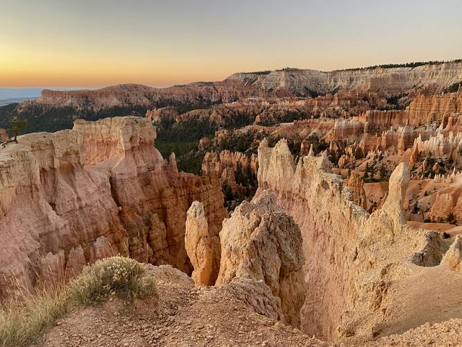
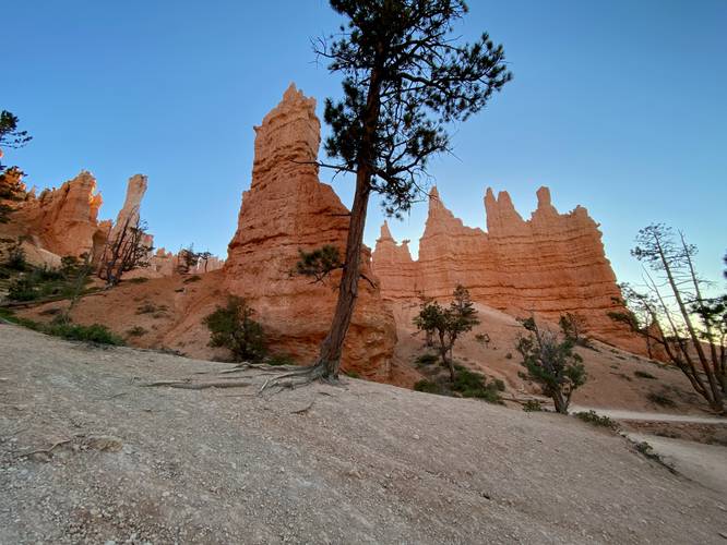
Hikers will hop on the Queen's Garden Trail around mile 0.2. The elevation grade of the trail is moderate at worst, making for an easy descent into Bryce Canyon. Along the way, hikers will get views into the canyon below their feet, mostly to the south. Some views lie due-East especially during sunrise where you can watch the sun slowly make its way over the distant mountains. Hikers will follow some switchbacks down the trail, but for the most part it's an easy hike down. Finally, at mile 0.7, hikers will reach a very short out-and-back walk to reach the base of the E.T. Hoodoo. Note that as of September 2023, the current map tile label for the E.T. Hoodoo is incorrect.
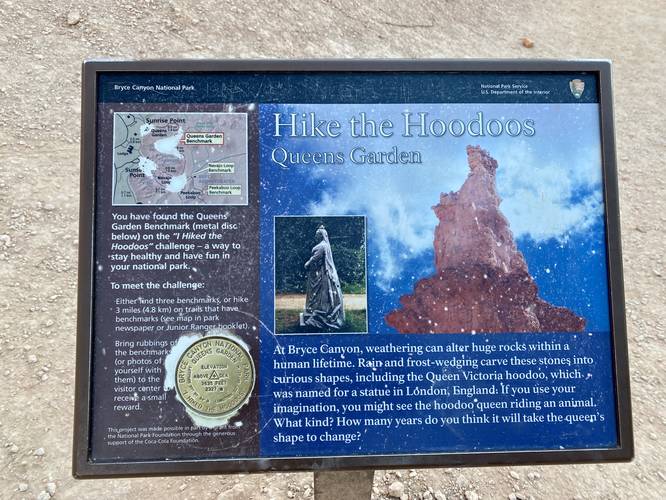
Reaching the Queen Victoria Hoodoo - Mile 0.72 to 1.1
From the E.T. Hoodoo, hikers will head back to the Queen's Garden Trail to continue its descent via switchbacks, before passing through a rock wall doorway, to reach a spur trail that leads to the Queen Victoria Hoodoo. Hikers will reach the Queen Victoria Hoodoo around mile 1.1, where they'll also find a "I Hiked the Hoodoos" benchmark at the same location. Note that the Queen Victoria Hoodoo is located directly in front of the benchmark sign, but I personally found it difficult to find the resemblance in the statue that it's supposed to look like.
Reaching the Navajo Loop - Mile 1.1 to 1.95
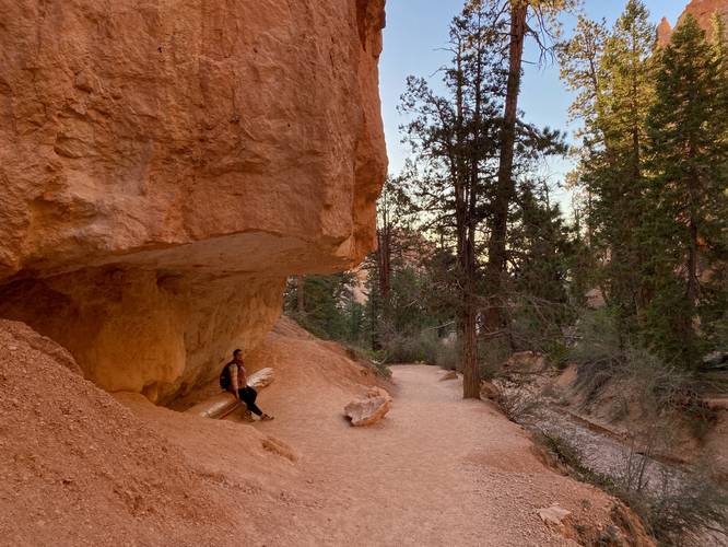
After visiting the Queen Victoria Hoodoo, hikers will continue following the trail as it leads southward to reach the Navajo Loop. Along the way, hikers will find several points-of-interest including another rock wall doorway, a cliff overhang with a large tree for a bench, and some neat hoodoo shapes. Around mile 1.95, hikers will reach the junction with the Navajo Loop.
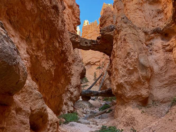
Two Bridges Arches - Mile 2.2
Once on the Navajo Loop, hikers will find a moderate (at worst) elevation grade that leads up and out of Bryce Canyon, but along the way hikers have plenty of POI to explore including the Two Bridges arches. At mile 2.2, hikers will find a very short spur trail that leads to a view of the natural bridge arches that sit just up-canyon from the viewpoint. This is a nice spot to enjoy before ascending the Navajo Loop's scenic switchbacks.
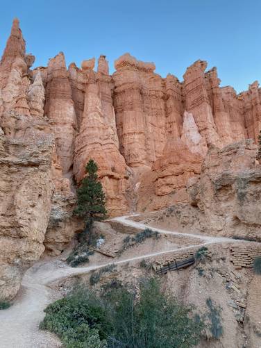
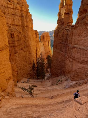
Navajo Loop Switchbacks - Mile 2.3 to 2.4
At mile 2.3, after hiking up the canyon a bit, hikers will reach one of the most-scenic spots along the trail - the Navajo Loop switchbacks. This iconic location provides hikers with views into Bryce Canyon through a narrow canyon where, at the foreground, are six or more switchbacks that make-up the trail. These switchbacks are well-worth photographing on your way up (or down, if you wish to hike that direction).
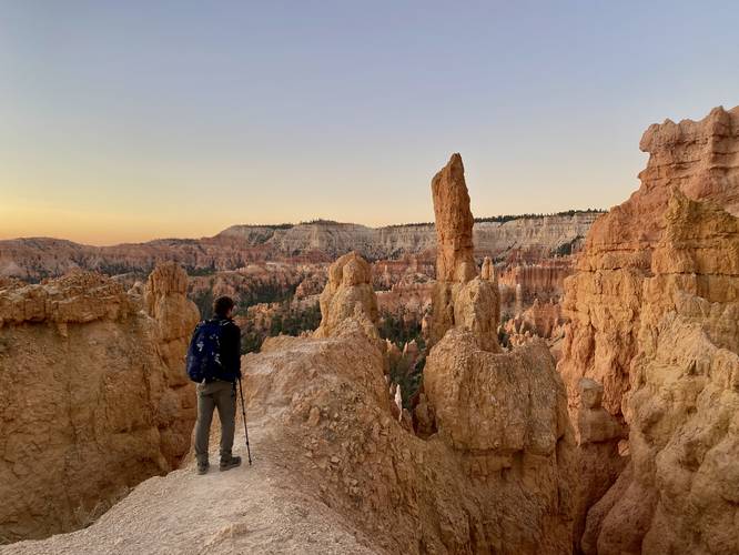
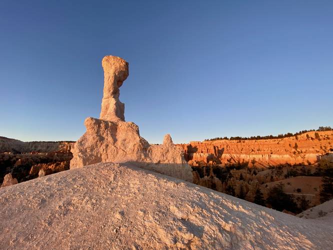
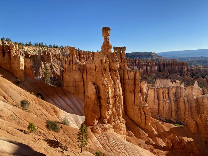
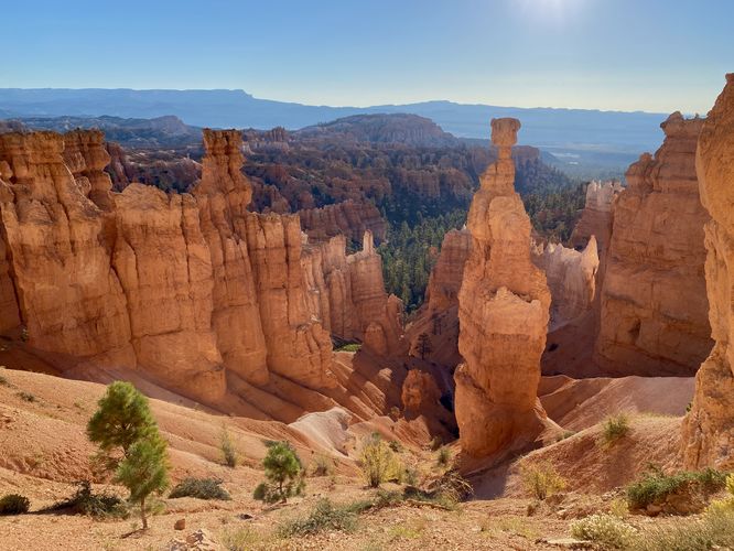
Thor's Hammer Hoodoo - Mile 2.4 to 2.5
Just after the scenic switchbacks, hikers will reach a view of Thor's Hammer - another large hoodoo that sits off-trail. Thor's Hammer will be in-view basically until you leave Sunset Point (mile 2.7ish), but the best views of Thor's Hammer are from about mile 2.4 to 2.5. Here, the trail leads up and out of the canyon along a steeper-grade but doesn't last for very long, just be mindful of the steep drops located on the side of the trail.
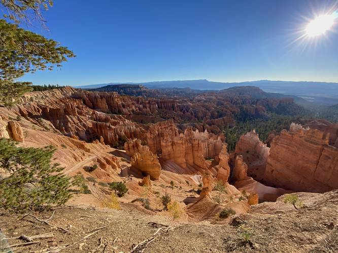
Sunset Point - Mile 2.65
Hikers will pass the Wall Street Trail junction at mile 2.6 and then be officially out of Bryce Canyon and onto its rim around mile 2.65, where Sunset Point is located. From Sunset Point, hikers will get more views into Bryce Canyon and of course, more views of Thor's Hammer. Here, the GPS data heads to the west side of Sunset Point where I made a backcountry espresso before continuing the loop.
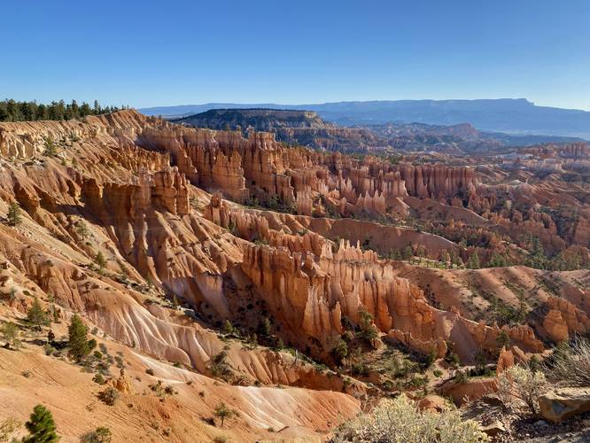
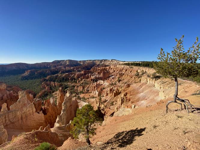
Rim Trail to Sunrise Point - Mile 2.7 to 3.2
Hikers will now be following the Rim Trail as they make their way back to parking, but along the way are more stunning views into Bryce Canyon from its rim. Definitely take your time along this section and don't forget to take photos on your way out from the rim. Hikers will reach Sunrise Point around mile 3.2 - this data heads up and out from Sunrise Point where we enjoyed the last views of Bryce Canyon before this hike was done.
Sunrise Point to Parking - Mile 3.2 to 3.4
From Sunrise Point, hikers will head back to the trailhead / parking lot where they began the hike for a 3.4-mile loop.
Popularity
This is one of the most-popular hikes at Bryce Canyon National Park, so expect to see plenty of people on the trail. Upon our hike here, we showed up before sunrise to find Sunrise Point littered with people, so we immediately began our hike down the Queen's Garden Trail. This was the best call we could've made as everyone waited for Sunrise, so we essentially had this entire loop to ourselves by skipping sunrise. We saw two other groups of hikers (5 people total) before the Navajo Loop and then saw less than 20 people as we hiked out along the Navajo Loop by starting super early.
Fees
Bryce Canyon National Park has a $35/week entry fee as of September 2023. Visitors are highly encouraged to purchase an annual National Parks pass before their trip to reduce entry fees (especially if you're passing through multiple parks) and to also speed-up the very-long line that leads into the park.
Parking
Visitors will find a large parking lot at the coordinates provided for Sunrise Point.
Pets
Dogs are not allowed on this trail.
Warnings
Sun exposure: This trail has very little shade during mid-day as the sun beats down directly on the trail. Bring plenty of water (1-gallon per person per day) and sun protection if planning to hike during mid-day sun, otherwise it's smart to plan to hike in the early morning or evening. If hiking this trail during the morning or evening, you'll receive plenty of shade from the massive canyon walls with some exceptions.
Rattlesnakes: Rattlesnakes call this area home and could be found out on the trail during warm/hot months. If found, please give these snakes plenty of space.
Rockfalls: This trail passes under large rock formations that sometimes have rockfall activity. There's no warning and nothing anyone can do about rockfalls, but just be mindful.
Trails
This hike follows three named trails Rim Trail, Queen's Garden Trail, Navajo Loop. This hike follows a clockwise loop starting at Sunrise Point.
Hike Description
This hike begins at the main parking lot for Sunrise Point and follows the paved universally-accessible pathway in to reach the Rim Trail. Once at the Rim Trail, hikers will head south to reach the trailhead for the Queen's Garden Trail.
Queen's Garden Trail to E.T. Hoodoo - Mile 0.2 to 0.7
Hikers will hop on the Queen's Garden Trail around mile 0.2. The elevation grade of the trail is moderate at worst, making for an easy descent into Bryce Canyon. Along the way, hikers will get views into the canyon below their feet, mostly to the south. Some views lie due-East especially during sunrise where you can watch the sun slowly make its way over the distant mountains. Hikers will follow some switchbacks down the trail, but for the most part it's an easy hike down. Finally, at mile 0.7, hikers will reach a very short out-and-back walk to reach the base of the E.T. Hoodoo. Note that as of September 2023, the current map tile label for the E.T. Hoodoo is incorrect.
Reaching the Queen Victoria Hoodoo - Mile 0.72 to 1.1
From the E.T. Hoodoo, hikers will head back to the Queen's Garden Trail to continue its descent via switchbacks, before passing through a rock wall doorway, to reach a spur trail that leads to the Queen Victoria Hoodoo. Hikers will reach the Queen Victoria Hoodoo around mile 1.1, where they'll also find a "I Hiked the Hoodoos" benchmark at the same location. Note that the Queen Victoria Hoodoo is located directly in front of the benchmark sign, but I personally found it difficult to find the resemblance in the statue that it's supposed to look like.
Reaching the Navajo Loop - Mile 1.1 to 1.95
After visiting the Queen Victoria Hoodoo, hikers will continue following the trail as it leads southward to reach the Navajo Loop. Along the way, hikers will find several points-of-interest including another rock wall doorway, a cliff overhang with a large tree for a bench, and some neat hoodoo shapes. Around mile 1.95, hikers will reach the junction with the Navajo Loop.
Two Bridges Arches - Mile 2.2
Once on the Navajo Loop, hikers will find a moderate (at worst) elevation grade that leads up and out of Bryce Canyon, but along the way hikers have plenty of POI to explore including the Two Bridges arches. At mile 2.2, hikers will find a very short spur trail that leads to a view of the natural bridge arches that sit just up-canyon from the viewpoint. This is a nice spot to enjoy before ascending the Navajo Loop's scenic switchbacks.
Navajo Loop Switchbacks - Mile 2.3 to 2.4
At mile 2.3, after hiking up the canyon a bit, hikers will reach one of the most-scenic spots along the trail - the Navajo Loop switchbacks. This iconic location provides hikers with views into Bryce Canyon through a narrow canyon where, at the foreground, are six or more switchbacks that make-up the trail. These switchbacks are well-worth photographing on your way up (or down, if you wish to hike that direction).
Thor's Hammer Hoodoo - Mile 2.4 to 2.5
Just after the scenic switchbacks, hikers will reach a view of Thor's Hammer - another large hoodoo that sits off-trail. Thor's Hammer will be in-view basically until you leave Sunset Point (mile 2.7ish), but the best views of Thor's Hammer are from about mile 2.4 to 2.5. Here, the trail leads up and out of the canyon along a steeper-grade but doesn't last for very long, just be mindful of the steep drops located on the side of the trail.
Sunset Point - Mile 2.65
Hikers will pass the Wall Street Trail junction at mile 2.6 and then be officially out of Bryce Canyon and onto its rim around mile 2.65, where Sunset Point is located. From Sunset Point, hikers will get more views into Bryce Canyon and of course, more views of Thor's Hammer. Here, the GPS data heads to the west side of Sunset Point where I made a backcountry espresso before continuing the loop.
Rim Trail to Sunrise Point - Mile 2.7 to 3.2
Hikers will now be following the Rim Trail as they make their way back to parking, but along the way are more stunning views into Bryce Canyon from its rim. Definitely take your time along this section and don't forget to take photos on your way out from the rim. Hikers will reach Sunrise Point around mile 3.2 - this data heads up and out from Sunrise Point where we enjoyed the last views of Bryce Canyon before this hike was done.
Sunrise Point to Parking - Mile 3.2 to 3.4
From Sunrise Point, hikers will head back to the trailhead / parking lot where they began the hike for a 3.4-mile loop.
Popularity
This is one of the most-popular hikes at Bryce Canyon National Park, so expect to see plenty of people on the trail. Upon our hike here, we showed up before sunrise to find Sunrise Point littered with people, so we immediately began our hike down the Queen's Garden Trail. This was the best call we could've made as everyone waited for Sunrise, so we essentially had this entire loop to ourselves by skipping sunrise. We saw two other groups of hikers (5 people total) before the Navajo Loop and then saw less than 20 people as we hiked out along the Navajo Loop by starting super early.
Fees
Bryce Canyon National Park has a $35/week entry fee as of September 2023. Visitors are highly encouraged to purchase an annual National Parks pass before their trip to reduce entry fees (especially if you're passing through multiple parks) and to also speed-up the very-long line that leads into the park.
Parking
Visitors will find a large parking lot at the coordinates provided for Sunrise Point.
Pets
Dogs are not allowed on this trail.
Warnings
Sun exposure: This trail has very little shade during mid-day as the sun beats down directly on the trail. Bring plenty of water (1-gallon per person per day) and sun protection if planning to hike during mid-day sun, otherwise it's smart to plan to hike in the early morning or evening. If hiking this trail during the morning or evening, you'll receive plenty of shade from the massive canyon walls with some exceptions.
Rattlesnakes: Rattlesnakes call this area home and could be found out on the trail during warm/hot months. If found, please give these snakes plenty of space.
Rockfalls: This trail passes under large rock formations that sometimes have rockfall activity. There's no warning and nothing anyone can do about rockfalls, but just be mindful.