The Montville Nature Loop Trail at Great Sand Dunes National Park
near Mosca, Colorado is an easy 0.5-mile loop hike that
features views of North America's tallest sand dunes, a forest creek, and tiny cascading waterfalls.
Hike
This short hike begins at the main parking lot for the Mosca Pass trailhead and this trail, the Montville Nature Loop Trail. As an alternative starting point, hikers can also begin at the visitors center, hiking in on the Great Sand Dunes View Trail (Mosca Pass) to reach this trailhead for additional mileage and different views.
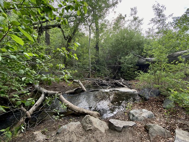
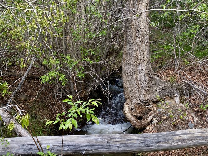
The hike start-off by heading uphill into a thick forest, which is a nice change of pace from the wide-open terrain and scrubland of the Great Sand Dunes View Trail. Along the way up the loop, hikers will hear Mosca Creek flowing down from the mountains, which spills out into a wide and shallow creek that sits below the sand dunes known as Medano Creek. Mosca Creek is mostly seasonal, during snow melt season, or after periods of heavy or constant rain. During our hike here in early June 2024, the creek was flowing heavily featured a multitude of very-short slide waterfalls and cascades that flowed down the hill.
The trail eventually crosses Mosca Creek before heading back downhill toward the trailhead. Along the way down are spots to take breaks at benches that sit along the flowing water.
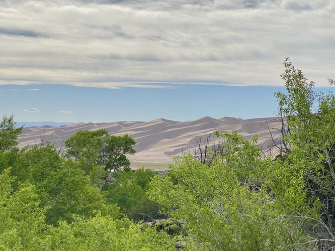
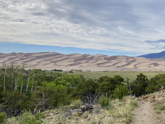
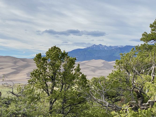
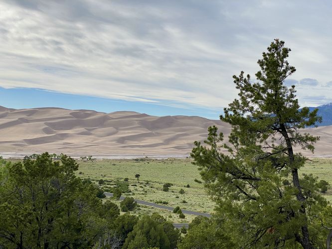
Dune and Mountain Views - Mile 0.3 to 0.45
The trail eventually leads out into a less-shaded area along switchbacks as you hike back downhill to the trailhead, but the views of the Great Sand Dunes and the Sangre de Cristo Mountains start to pop again. Hikers will find views of both until approximately mile 0.45 in this route where the trail dips back into the woods.
Small Waterfall / Cascades - Mile 0.48
Just before the trail ends, it crosses Mosca Creek one last time. When the water's flowing, you'll find a slightly-hidden (by the nearby brush) 2-foot tall slide waterfall that cascades down the creek. While this tiny waterfall isn't much, it's a nice addition to the scenery along the trail.
The hike end around mile 0.5 at the parking lot which completes the loop.
Other Hikes
While the park has many longer trails to explore, including the dunes themselves, if you don't have much time to spend at the park consider hiking the Great Sand Dunes View Trail (Mosca Pass) to reach this trail or hike the Sand Sheet Interpretive Trail near the visitors center.
Pets
Dogs are allowed on this trail only if leashed and cleaned up after. Click here more information on where dogs are and are not allowed at Great Sand Dunes National Park.
Parking
Hikers will find a small parking lot at the coordinates provided, located at the Mosca Pass trailhead / Montville Nature Loop trailhead. The lot is large enough to fit less than a dozen vehicles as of June 2024.
How were the Great Sand Dunes Formed?
Ten thousand years ago, this area was covered with lakes surrounded by wetlands. When the climate became drier, vegetation disappeared, leaving a sheet of sand and silt. Winds transported these deposits to form the dunes. The Great Sand Dunes are North America's tallest dunes, some of which reach heights of 750-feet tall.
Fees
There's a $25/vehicle entry fee as of June 2024 (subject to change). Entering the park is faster if you purchase an Annual National Parks pass ahead of time. You can learn more about Great Sand Dunes National Park entrance fees here.
Warning
Excessive heat: During the day, the heat can climb to unsafe temperatures, especially when hiking in exposed areas with little shade. Remember to bring plenty of water and to stay hydrated.
Hike
This short hike begins at the main parking lot for the Mosca Pass trailhead and this trail, the Montville Nature Loop Trail. As an alternative starting point, hikers can also begin at the visitors center, hiking in on the Great Sand Dunes View Trail (Mosca Pass) to reach this trailhead for additional mileage and different views.
The hike start-off by heading uphill into a thick forest, which is a nice change of pace from the wide-open terrain and scrubland of the Great Sand Dunes View Trail. Along the way up the loop, hikers will hear Mosca Creek flowing down from the mountains, which spills out into a wide and shallow creek that sits below the sand dunes known as Medano Creek. Mosca Creek is mostly seasonal, during snow melt season, or after periods of heavy or constant rain. During our hike here in early June 2024, the creek was flowing heavily featured a multitude of very-short slide waterfalls and cascades that flowed down the hill.
The trail eventually crosses Mosca Creek before heading back downhill toward the trailhead. Along the way down are spots to take breaks at benches that sit along the flowing water.
Dune and Mountain Views - Mile 0.3 to 0.45
The trail eventually leads out into a less-shaded area along switchbacks as you hike back downhill to the trailhead, but the views of the Great Sand Dunes and the Sangre de Cristo Mountains start to pop again. Hikers will find views of both until approximately mile 0.45 in this route where the trail dips back into the woods.
Small Waterfall / Cascades - Mile 0.48
Just before the trail ends, it crosses Mosca Creek one last time. When the water's flowing, you'll find a slightly-hidden (by the nearby brush) 2-foot tall slide waterfall that cascades down the creek. While this tiny waterfall isn't much, it's a nice addition to the scenery along the trail.
The hike end around mile 0.5 at the parking lot which completes the loop.
Other Hikes
While the park has many longer trails to explore, including the dunes themselves, if you don't have much time to spend at the park consider hiking the Great Sand Dunes View Trail (Mosca Pass) to reach this trail or hike the Sand Sheet Interpretive Trail near the visitors center.
Pets
Dogs are allowed on this trail only if leashed and cleaned up after. Click here more information on where dogs are and are not allowed at Great Sand Dunes National Park.
Parking
Hikers will find a small parking lot at the coordinates provided, located at the Mosca Pass trailhead / Montville Nature Loop trailhead. The lot is large enough to fit less than a dozen vehicles as of June 2024.
How were the Great Sand Dunes Formed?
Ten thousand years ago, this area was covered with lakes surrounded by wetlands. When the climate became drier, vegetation disappeared, leaving a sheet of sand and silt. Winds transported these deposits to form the dunes. The Great Sand Dunes are North America's tallest dunes, some of which reach heights of 750-feet tall.
Fees
There's a $25/vehicle entry fee as of June 2024 (subject to change). Entering the park is faster if you purchase an Annual National Parks pass ahead of time. You can learn more about Great Sand Dunes National Park entrance fees here.
Warning
Excessive heat: During the day, the heat can climb to unsafe temperatures, especially when hiking in exposed areas with little shade. Remember to bring plenty of water and to stay hydrated.