The Great Sand Dunes View Trail (Mosca Pass) at Great Sand Dunes National Park near Mosca, Colorado is an easy 0.5-mile out-and-back hike that features views of North America's tallest sand dunes and leads to the Montville Nature Loop Trail.
Hike
This short hike begins at the visitors center for Great Sand Dunes National Park where you'll find a discrete trailhead located on the far northeastern side of the parking lot. This trail is the trailhead for Mosca Pass; however, the trail itself appears to be unnamed as most hikers start Mosca Pass at the Montville Nature Loop Trail trailhead instead.
The dirt trail leads uphill for most of the way as it meanders through scrubland and low-growing trees for most of the walk. During late Spring you might find flowering cacti located just off-trail - during our visit in early June 2024, we found yellow flowering prickly pear cacti.
Great Sand Dune Views - Mile 0.1, 0.13, 0.18
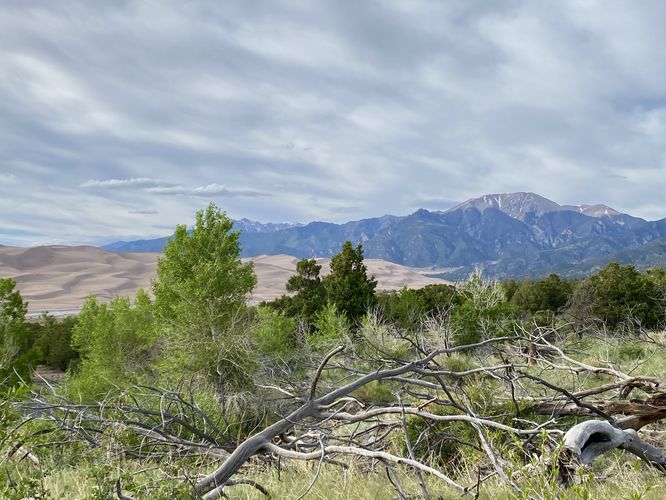
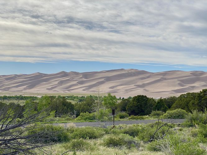
Not far up the trail from the start, just after crossing the main park road, you'll start to get views of the Great Sand Dunes with the Sangre De Cristo Mountains behind. During our visit in early June 2024, we found snow in the high elevation mountains with the Sand Dunes in the foreground and a shallow creek of snow melt that sat between us and the Sand Dunes -- this picturesque scenery, while a bit odd, was unmatched with the combination of everything nature had to offer us that day.
We then hiked the Montville Nature Loop Trail for similar views and to explore Great Sand Dunes National Park a bit more during our short visit.
Other Hikes
While the park has many longer trails to explore, including the dunes themselves, if you don't have much time to spend at the park consider hiking the Montville Nature Loop Trail or hike the Sand Sheet Interpretive Trail near the visitors center.
Pets
Dogs are allowed on this trail only if leashed and cleaned up after. Click here more information on where dogs are and are not allowed at Great Sand Dunes National Park.
Parking
Hikers will find a very large parking lot at the coordinates provided, located at the main visitors center for the park. The lot is large enough to fit many dozens of vehicles as of June 2024.
How were the Great Sand Dunes Formed?
Ten thousand years ago, this area was covered with lakes surrounded by wetlands. When the climate became drier, vegetation disappeared, leaving a sheet of sand and silt. Winds transported these deposits to form the dunes. The Great Sand Dunes are North America's tallest dunes, some of which reach heights of 750-feet tall.
Fees
There's a $25/vehicle entry fee as of June 2024 (subject to change). Entering the park is faster if you purchase an Annual National Parks pass ahead of time. You can learn more about Great Sand Dunes National Park entrance fees here.
Warning
Excessive heat: During the day, the heat can climb to unsafe temperatures, especially when hiking in exposed areas with little shade. Remember to bring plenty of water and to stay hydrated.
Hike
This short hike begins at the visitors center for Great Sand Dunes National Park where you'll find a discrete trailhead located on the far northeastern side of the parking lot. This trail is the trailhead for Mosca Pass; however, the trail itself appears to be unnamed as most hikers start Mosca Pass at the Montville Nature Loop Trail trailhead instead.
The dirt trail leads uphill for most of the way as it meanders through scrubland and low-growing trees for most of the walk. During late Spring you might find flowering cacti located just off-trail - during our visit in early June 2024, we found yellow flowering prickly pear cacti.
Great Sand Dune Views - Mile 0.1, 0.13, 0.18
Not far up the trail from the start, just after crossing the main park road, you'll start to get views of the Great Sand Dunes with the Sangre De Cristo Mountains behind. During our visit in early June 2024, we found snow in the high elevation mountains with the Sand Dunes in the foreground and a shallow creek of snow melt that sat between us and the Sand Dunes -- this picturesque scenery, while a bit odd, was unmatched with the combination of everything nature had to offer us that day.
We then hiked the Montville Nature Loop Trail for similar views and to explore Great Sand Dunes National Park a bit more during our short visit.
Other Hikes
While the park has many longer trails to explore, including the dunes themselves, if you don't have much time to spend at the park consider hiking the Montville Nature Loop Trail or hike the Sand Sheet Interpretive Trail near the visitors center.
Pets
Dogs are allowed on this trail only if leashed and cleaned up after. Click here more information on where dogs are and are not allowed at Great Sand Dunes National Park.
Parking
Hikers will find a very large parking lot at the coordinates provided, located at the main visitors center for the park. The lot is large enough to fit many dozens of vehicles as of June 2024.
How were the Great Sand Dunes Formed?
Ten thousand years ago, this area was covered with lakes surrounded by wetlands. When the climate became drier, vegetation disappeared, leaving a sheet of sand and silt. Winds transported these deposits to form the dunes. The Great Sand Dunes are North America's tallest dunes, some of which reach heights of 750-feet tall.
Fees
There's a $25/vehicle entry fee as of June 2024 (subject to change). Entering the park is faster if you purchase an Annual National Parks pass ahead of time. You can learn more about Great Sand Dunes National Park entrance fees here.
Warning
Excessive heat: During the day, the heat can climb to unsafe temperatures, especially when hiking in exposed areas with little shade. Remember to bring plenty of water and to stay hydrated.