Loading...

🎆 50% off 4th of July sale on Supporter Accounts — now through July 6! Learn More.

Mill Shoals and Bird Rock Falls Hike

Directions
Map
Pictures
Send to App
Distance:
0.6 Miles / 1.0 km
Type:
Out-and-Back
Difficulty:
Easy
Time to Hike:
~18 minutes
Features:
Surface Type:
Dirt
Town:
Balsam Grove, North Carolina
Directions:
35.222674, -82.860497
Added:
April 01, 2025
Updated:
April 06, 2025
Copy Trail Link Hiking this trail? Send a friend or family member a link to this trail guide for your own safety. Hike at your own risk (disclaimer)
Loading...
Loading...
73'

Total Change
73'

Ascent
69'

Descent

Download the Trail Route for Offline Use

Supporters get exclusive access to download trail routes to the MyHikes app for offline use. Stay prepared on your adventure, even without an internet connection! Become a Supporter today to unlock this feature and hike with confidence.

Send to App

Mill Shoals and Bird Rock Falls Hike

A short, scenic stretch of the North Fork French Broad River along NC 215 is home to Mill Shoals and Bird Rock Falls. The land is owned by the Living Waters Ministry, but thankfully they allow public access to see these majestic waterfalls. Mill Shoals, also known as French Broad Falls, is a twin waterfall at the confluence of Shoal Creek and the North Fork French Broad River. Both falls drop approximately 15 feet over a ledge, with Shoal Creek cascading below an old red house. A maintained trail follows the river downstream, passing by two small waterfalls in succession before ending at Bird Rock Falls. Although Bird Rock Falls is listed as a modest 20 feet, the setting below a towering cliff is spectacular.

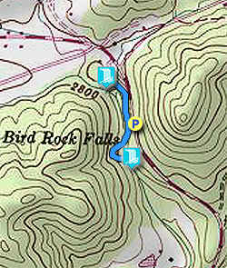
Parking – You might see visitors parking at the main lot for Living Waters Ministry, but for waterfall visitors it is encouraged to park on the long shoulder of NC 215. The parking lot at the buildings is reserved for guests.

  • Mile 0.0 – Follow the shoulder of NC 215 north towards the Living Waters Ministry. Before you reach the main entrance turn left on the gravel road below the red house.

  • Mile 0.1 – Reach the base of Mill Shoals, a set of twin waterfalls at the confluence of Shoal Creek (right/river left) and North Fork French Broad River (left/river right). (These waterfalls are also known separately as French Broad Falls (left) and Mill Shoals or Shoal Creek Falls (right), but Mill Shoals is the official name for the twin waterfalls.) The larger North Fork French Broad River spills over a wide ledge. Shoal Creek cascades below a scenic red house. A maintained trail follows the river downstream to Bird Rock Falls.

  • Mile 0.2 – The trail passes by two small waterfalls in succession. The lower one is difficult to reach due to the gradient of the rock face.

  • Mile 0.3 – Pass by the top of Bird Rock Falls. You can walk onto the bedrock here to admire the massive cliff towering above the waterfall. The trail ends at the base of Bird Rock Falls. Although the waterfall is only 20 feet high, the scene is impressive. The powerful flow of the river has exposed all of the surrounding bedrock. A tall, imposing cliff towers above the river right side of the falls. This is a great waterfall to visit any time of year, with any level of water.

  • Mile 0.6 – Return to the highway. You can walk all the way back to the entrance road beside Mill Shoals, or use one of the shortcuts you’ll come across directly up the bank.
By HikingUpward Contributor: Zach Robbins
Explore 16 trails near Balsam Grove, NC
  1. Parking

    35.222674, -82.860497
  2. Main Trailhead

    35.222563, -82.860426
No community routes found. To add your own hike as a Community Route for this Trail guide, leave a Trip Report with an attached GPX file.

Hazards

Snakes
Poison Ivy/Oak

Seasons

All

Trip Reports

Trail Guide By:
HikingUpward user profile picture
0.6 miles / 1.0 km

Weather Forecast

In Balsam Grove, NC

Explore Hiking Trails

You May Also Like

Colorado's Million Dollar Highway - Plan a day's drive adventure along the iconic Million Dollar Highway in Colorado. Explore the best short trails, roadside stops, waterfalls, vistas, ghost towns, and hot springs within a ~6 hour road trip.
Explore

Colorado's Million Dollar Highway

Plan a day's drive adventure along the iconic Million Dollar Highway in Colorado. Explore the best short trails, roadside stops, waterfalls, vistas, ghost towns, and hot springs within a ~6 hour road trip.

Read
Glacier's Going-to-the-Sun Road - Discover the breathtaking beauty of Glacier National Park along the iconic Going-to-the-Sun Road. From stunning roadside stops to picturesque waterfalls and vistas, this engineering marvel offers endless opportunities for exploration.
Explore

Glacier's Going-to-the-Sun Road

Discover the breathtaking beauty of Glacier National Park along the iconic Going-to-the-Sun Road. From stunning roadside stops to picturesque waterfalls and vistas, this engineering marvel offers endless opportunities for exploration.

Read
New York's Best Waterfalls - Whether you're planning a day hike, roadside stop, or a leisurely short walk, this guide provides hikers, travelers, and locals alike with 63 different locations to over 100 scenic waterfalls to help plan your next adventure!
Explore

New York's Best Waterfalls

Whether you're planning a day hike, roadside stop, or a leisurely short walk, this guide provides hikers, travelers, and locals alike with 63 different locations to over 100 scenic waterfalls to help plan your next adventure!

Read
25 Best Day Hikes in North Carolina - Discover the top 25 best day hikes in North Carolina, from breathtaking waterfalls to mountain peaks. Explore hidden gems, scenic views, and trails suitable for all skill levels, perfect for your next outdoor adventure.
Explore

25 Best Day Hikes in North Carolina

Discover the top 25 best day hikes in North Carolina, from breathtaking waterfalls to mountain peaks. Explore hidden gems, scenic views, and trails suitable for all skill levels, perfect for your next outdoor adventure.

Read

Before you boogie...

Find our trail guides useful? Consider becoming a Supporter to unlock perks!

MyHikes is an indie platform that makes exploring public trails easier for everyone. The platform has no investors, no ads, and is owned and operated by one person, Dave Miller. Dave has personally mapped and written over 1,800 trail guides on MyHikes for the public to explore. MyHikes has helped millions outdoor enthusiasts plan their next adventure.

But it takes a lot of time 🕦, money 💰, work, and espresso shots ☕ to run MyHikes, including hiking , mapping , writing , and publishing new trails with high-quality (accurate) information... along with software engineering (coding) the platform like building new features, website and mobile app development (iOS and Android), site maintainance . and much much more.

Supporters unlock website and mobile app perks with an annual one-time payment of $25 (you renew) 😎👍. Or you can simply make a Donation of your choice. Otherwise, you can support us by telling your friends about MyHikes - both quick and free 🎉

Admin user profile picture

Dave Miller
MyHikes Founder