The Many Pools Hike at Zion National Park in Washington County, Utah is a moderate 1-mile out-and-back off-trail hike that leads to the secluded desert potholes known as the Many Pools and features two slot canyons and one tunnel.
Trails
Note that this hike does not follow an official trail and instead is completely off-trail. Do not attempt to hike this unless you're comfortable navigating off-trail terrain and the warnings that this hike poses.
Hike Description
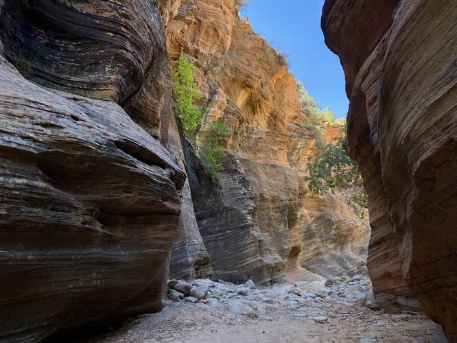
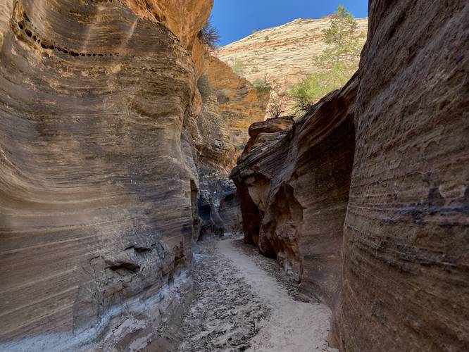
This hike begins at the parking coordinates provided and heads due-south following a loosely-defined sandy pathway that cuts through the low shrubs to reach the dry wash of Clear Creek below. Once at Clear Creek, hikers will head westward, passing through the first slot canyon. This first slot canyon of Clear Creek is beautiful with tall multi-colored cliffs that extend the length of the wash in a wavy pattern - carved out by eons of flowing water. The trail then opens up more as the creek bends its way out of one slot canyon and into another. The second slot canyon, located around mile 0.25, is a skinnier canyon with less colorful cliffs but is still scenic nonetheless.
Highway Tunnel / Right-Hand Turn - Mile 0.28
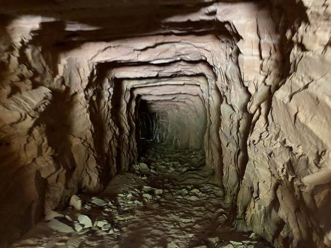
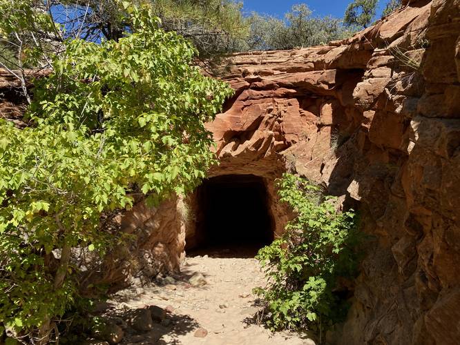
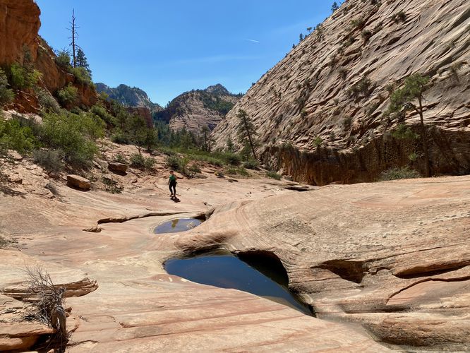
Around mile 0.28, hikers will hopefully notice the highway tunnel located on their right-hand side. Hike into and through the tunnel to pass under the highway and reach a different tributary dry wash. While hiking through the tunnel keep in mind that this section of the hike also has rockfall activity, so keep moving to stay safe. Also use a flashlight to find your way and to not trip on fallen rocks! Once on the other side of the tunnel, the hike leads due-north within the dry wash to reach the potholes known as the Many Pools.
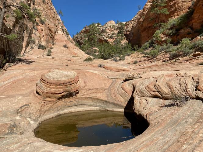
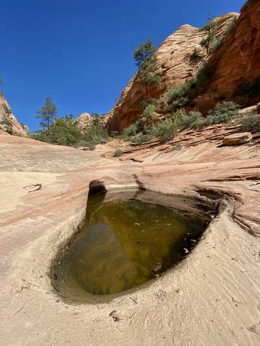
Many Pools - Mile 0.45
Finally, hikers will reach the lower section of the Many Pools potholes around mile 0.45. The lower pools are by far the smallest, skinniest, and least-interesting of the Many Pools potholes, so continue uphill along the open bedrock. You'll find more potholes, some "very" deep - at least 3 or 4-feet deep, which line the bedrock. There are about ~5 potholes in total that are worth taking a look at on this hike. The Upper Pools of Many Pools provides a neat view looking back downhill toward where you hiked-in from.
Hiking Out (Options)
Note that the hike out is pretty simple and easy - you can follow the same path back that you took in. The only downside is there are a few dangerous sections like the two slot canyons and the tunnel. If you wish, you can instead take the danger of hiking alongside the highway. There are a few small footpaths that lead up to the highway from the northern dry wash near Many Pools -- hikers can, if they choose, to take that route and walk back to parking for a shorter distance.
Parking
Hikers will find parking at the coordinates provided. The lot is large enough to fit over a dozen vehicles.
Pets
Dogs are not allowed on this trail. Zion National Park, as of September 2023, only allows leashed dogs on the Pa'rus Trail and nowhere else other than paved parking lots.
Seclusion
During our hike here in September 2023, there were ~10 or more cars at the parking lot with people surrounding; however, we were the only hikers on the path and the only people at the Many Pools section. This is a secluded hidden gem at Zion National Park that very few people know exists. If you enjoy seclusion, assuming this write-up has not become popular, you can find it at the Many Pools.
Warnings
Flash flooding: This hike follows two slot canyons and one tunnel - both of which follow dry washes / runs. Hikers must pay attention to local weather before their hike to ensure that they're not hiking in a dry wash during a rainstorm that might be occurring upstream.
Rattlesnakes: This hike leads into rattlesnake territory, so be on the lookout and give any you find plenty of space.
Mountain lions: While more rare, this hike passes through secluded areas where mountain lions could be present, especially around rare desert water sources like the Many Pools.
Falling rocks / rockfall: This hike passes cliffs and through one tunnel that have occasional rockfalls. Hike at your own risk.
Lack of water: Despite the potholes of water (Many Pools), this hike does not provide any potable, filterable, or drinkable water. You must pack-in all water.
Trails
Note that this hike does not follow an official trail and instead is completely off-trail. Do not attempt to hike this unless you're comfortable navigating off-trail terrain and the warnings that this hike poses.
Hike Description
This hike begins at the parking coordinates provided and heads due-south following a loosely-defined sandy pathway that cuts through the low shrubs to reach the dry wash of Clear Creek below. Once at Clear Creek, hikers will head westward, passing through the first slot canyon. This first slot canyon of Clear Creek is beautiful with tall multi-colored cliffs that extend the length of the wash in a wavy pattern - carved out by eons of flowing water. The trail then opens up more as the creek bends its way out of one slot canyon and into another. The second slot canyon, located around mile 0.25, is a skinnier canyon with less colorful cliffs but is still scenic nonetheless.
Highway Tunnel / Right-Hand Turn - Mile 0.28
Around mile 0.28, hikers will hopefully notice the highway tunnel located on their right-hand side. Hike into and through the tunnel to pass under the highway and reach a different tributary dry wash. While hiking through the tunnel keep in mind that this section of the hike also has rockfall activity, so keep moving to stay safe. Also use a flashlight to find your way and to not trip on fallen rocks! Once on the other side of the tunnel, the hike leads due-north within the dry wash to reach the potholes known as the Many Pools.
Many Pools - Mile 0.45
Finally, hikers will reach the lower section of the Many Pools potholes around mile 0.45. The lower pools are by far the smallest, skinniest, and least-interesting of the Many Pools potholes, so continue uphill along the open bedrock. You'll find more potholes, some "very" deep - at least 3 or 4-feet deep, which line the bedrock. There are about ~5 potholes in total that are worth taking a look at on this hike. The Upper Pools of Many Pools provides a neat view looking back downhill toward where you hiked-in from.
Hiking Out (Options)
Note that the hike out is pretty simple and easy - you can follow the same path back that you took in. The only downside is there are a few dangerous sections like the two slot canyons and the tunnel. If you wish, you can instead take the danger of hiking alongside the highway. There are a few small footpaths that lead up to the highway from the northern dry wash near Many Pools -- hikers can, if they choose, to take that route and walk back to parking for a shorter distance.
Parking
Hikers will find parking at the coordinates provided. The lot is large enough to fit over a dozen vehicles.
Pets
Dogs are not allowed on this trail. Zion National Park, as of September 2023, only allows leashed dogs on the Pa'rus Trail and nowhere else other than paved parking lots.
Seclusion
During our hike here in September 2023, there were ~10 or more cars at the parking lot with people surrounding; however, we were the only hikers on the path and the only people at the Many Pools section. This is a secluded hidden gem at Zion National Park that very few people know exists. If you enjoy seclusion, assuming this write-up has not become popular, you can find it at the Many Pools.
Warnings
Flash flooding: This hike follows two slot canyons and one tunnel - both of which follow dry washes / runs. Hikers must pay attention to local weather before their hike to ensure that they're not hiking in a dry wash during a rainstorm that might be occurring upstream.
Rattlesnakes: This hike leads into rattlesnake territory, so be on the lookout and give any you find plenty of space.
Mountain lions: While more rare, this hike passes through secluded areas where mountain lions could be present, especially around rare desert water sources like the Many Pools.
Falling rocks / rockfall: This hike passes cliffs and through one tunnel that have occasional rockfalls. Hike at your own risk.
Lack of water: Despite the potholes of water (Many Pools), this hike does not provide any potable, filterable, or drinkable water. You must pack-in all water.