Loading...

๐ŸŽ‰ Enjoy a Free 7-Day Supporter Trial and Unlock Exclusive Perks โ€” No Credit Card Required. Learn more.

Pa'rus Trail

Directions
Map
Pictures
Send to App
Distance:
1.2 Miles / 1.9 km
Type:
Out-and-Back
Difficulty:
Easy
Time to Hike:
~36 minutes
Features:
Surface Type:
Universal Access
Park:
Zion National Park
Town:
Springdale, Utah
Directions:
37.198024, -112.986766
Added:
September 25, 2023
Updated:
November 17, 2023
Copy Trail Link Hiking this trail? Send a friend or family member a link to this trail guide for your own safety. Hike at your own risk (disclaimer)
Loading...
Loading...
44'

Total Change
57'

Ascent
58'

Descent

Download the Trail Route for Offline Use

Supporters get exclusive access to download trail routes to the MyHikes app for offline use. Stay prepared on your adventure, even without an internet connection! Become a Supporter today to unlock this feature and hike with confidence.

Send to App

Pa'rus Trail

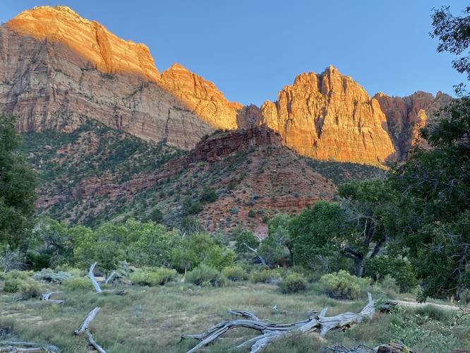
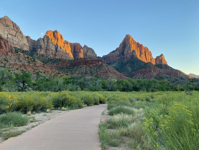
This section of the Pa'rus Trail at Zion National Park near Springdale, Utah is an easy 1.2-mile out-and-back trail that features views of the Virgin River and towering rock cliffs that surround Zion Valley.

This walk follows the Pa'rus Trail for just 0.6-miles one-way to take in the views of Zion Valley. For hikers planning a trip to Zion National Park during the busy season, you'll have to park at the visitors center, which provides quick access to the Pa'rus Trail. This trail is a great trail to take into the park if you plan to explore the park by foot instead of by shuttle service. The Pa'rus Trail is approximately 1.5-miles one-way from the visitors center to Zion Canyon Scenic Drive.

Universally Accessible
The Pa'rus Trail is paved and universally accessible.

Pets
This is the only trail at Zion National Park that allowed dogs, as of September 2023. Dogs must be leashed and cleaned up after.

Fees
Zion National Park has a $35/week entry fee as of September 2023. Visitors are highly encouraged to purchase an annual National Parks pass before their trip to reduce entry fees (especially if you're passing through multiple parks) and to also speed-up the insanely-long line that leads into the park.

Parking
Hikers will find parking at the visitors center parking lot, located at the coordinates provided. The lot is massive and fits hundreds of vehicles. The lot fills up quickly each morning during busy seasons, so showing up early helps ensure you find parking.
Explore 15 trails near Springdale, UT
  1. Parking

    37.198024, -112.986766
  2. Main Trailhead

    37.201789, -112.986856
  3. View of The Watchman from the Pa'rus Trail in Zion Valley

    37.202781, -112.982314
     View of The Watchman from the Pa'rus Trail in Zion Valley
  4. Views of Zion Valley along the Pa'rus Trail

    37.205861, -112.979994
     Views of Zion Valley along the Pa'rus Trail
No community routes found. To add your own hike as a Community Route for this Trail guide, leave a Trip Report with an attached GPX file.

Hazards

Snakes

Seasons

All

Trip Reports

Trail Guide By:
Admin user profile picture
1.2 miles / 1.9 km

Weather Forecast

In Springdale, UT

Explore Hiking Trails

You May Also Like

Colorado's Million Dollar Highway - Plan a day's drive adventure along the iconic Million Dollar Highway in Colorado. Explore the best short trails, roadside stops, waterfalls, vistas, ghost towns, and hot springs within a ~6 hour road trip.
Explore

Colorado's Million Dollar Highway

Plan a day's drive adventure along the iconic Million Dollar Highway in Colorado. Explore the best short trails, roadside stops, waterfalls, vistas, ghost towns, and hot springs within a ~6 hour road trip.

Read
Glacier's Going-to-the-Sun Road - Discover the breathtaking beauty of Glacier National Park along the iconic Going-to-the-Sun Road. From stunning roadside stops to picturesque waterfalls and vistas, this engineering marvel offers endless opportunities for exploration.
Explore

Glacier's Going-to-the-Sun Road

Discover the breathtaking beauty of Glacier National Park along the iconic Going-to-the-Sun Road. From stunning roadside stops to picturesque waterfalls and vistas, this engineering marvel offers endless opportunities for exploration.

Read
New York's Best Waterfalls - Whether you're planning a day hike, roadside stop, or a leisurely short walk, this guide provides hikers, travelers, and locals alike with 63 different locations to over 100 scenic waterfalls to help plan your next adventure!
Explore

New York's Best Waterfalls

Whether you're planning a day hike, roadside stop, or a leisurely short walk, this guide provides hikers, travelers, and locals alike with 63 different locations to over 100 scenic waterfalls to help plan your next adventure!

Read

Before you boogie...

Find our trail guides useful? Consider becoming a Supporter to unlock perks!

MyHikes is an indie platform that makes exploring public trails easier for everyone. The platform has no investors, no ads, and is owned and operated by one person, Dave Miller. Dave has personally mapped and written over 1,800 trail guides on MyHikes for the public to explore. MyHikes has helped millions outdoor enthusiasts plan their next adventure.

But it takes a lot of time ๐Ÿ•ฆ, money ๐Ÿ’ฐ, work, and espresso shots โ˜• to run MyHikes, including hiking , mapping , writing , and publishing new trails with high-quality (accurate) information... along with software engineering (coding) the platform like building new features, website and mobile app development (iOS and Android), site maintainance . and much much more.

Supporters unlock website and mobile app perks with an annual one-time payment of $25 (you renew) ๐Ÿ˜Ž๐Ÿ‘. Or you can simply make a Donation of your choice. Otherwise, you can support us by telling your friends about MyHikes - both quick and free ๐ŸŽ‰

Admin user profile picture

Dave Miller
MyHikes Founder