The Spring House Trail at Boyce Mayview Park in Upper St. Clair, Pennsylvania is an easy 0.1-mile one-way trail that features the abandoned remains of an old Spring House.
Hike Description
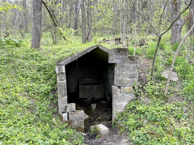
This trail is probably less than 50-feet long in total, but has its own name and connects the Birds Meadow Drive (walkable path) to the Many Habitats Trail - while also leading to the abandoned remains of an old Spring House.
As of April 2021, hikers will find an old concrete shed built into the hillside. Inside is, what looks like, an old trough where water still fills up today. In the bottom-left back corner, you may still find water flowing through the structure.
Pets
Dogs are allowed on this trail.
Parking
Hikers will find parking at the coordinates provided along Birds Meadow Drive, right off of Boyce Road in Upper St. Clair. The parking lot is large enough to fit about a dozen vehicles.
Biking
Biking is not allowed along this trail.
Connecting Trails
This trail connects with Birds Meadow Drive and the Many Habitats Trail.
Hike Description
This trail is probably less than 50-feet long in total, but has its own name and connects the Birds Meadow Drive (walkable path) to the Many Habitats Trail - while also leading to the abandoned remains of an old Spring House.
As of April 2021, hikers will find an old concrete shed built into the hillside. Inside is, what looks like, an old trough where water still fills up today. In the bottom-left back corner, you may still find water flowing through the structure.
Pets
Dogs are allowed on this trail.
Parking
Hikers will find parking at the coordinates provided along Birds Meadow Drive, right off of Boyce Road in Upper St. Clair. The parking lot is large enough to fit about a dozen vehicles.
Biking
Biking is not allowed along this trail.
Connecting Trails
This trail connects with Birds Meadow Drive and the Many Habitats Trail.