Luke's Falls at Lehigh Gorge State Park in Weatherly, Pennsylvania
is an easy universally-accessible 0.6-mile out-and-back hike that leads
to the 20-foot tall waterfall, Luke's Falls.
Trails
This hike follows one named trail: D&L Trail.
Universal Accessibility
The D&L Trail is universally-accessible and is accessible all the way to the viewing area for Luke's Falls.
Hike Description
This trail begins at the main parking lot for the Lehigh Gorge State Park Rockport Access. The main trail that hikers will follow is the D&L Trail which can be found on the Eastern side of the parking lot. The trail runs the length of the Lehigh Gorge, but this out-and-back hike follows a short segment. Hikers will walk South along the D&L Trail to head toward Luke's Falls. Along the way are non-flush restrooms and a seasonal potable water station.
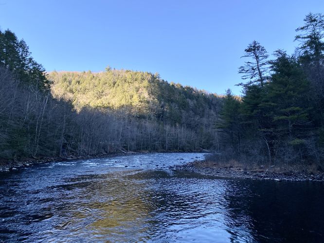
Lehigh River & Gorge View - Mile 0.1
Around mile 0.1, hikers will pass an off-shoot trail that leads down to massive boulders that sit along the edge of the Lehigh River. Here, you can get a nice view of the Lehigh River and Lehigh Gorge.
After passing the view, hikers will be back on the flat universally-accessible D&L Trail as it makes its way south through the Lehigh Gorge. Hikers will pass many old rhododendron on their way to Luke's Falls.
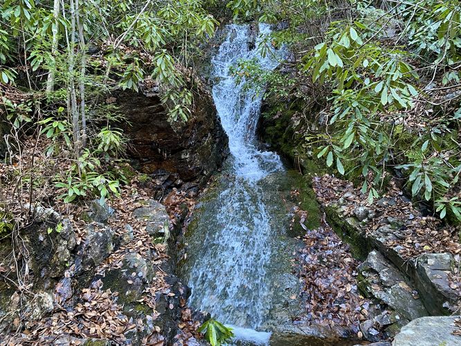
Luke's Falls - Mile 0.3
Around mile 0.3, hikers will reach the ~20-foot tall Luke's Falls. The viewing area for Luke's Falls is directly on-trail and the waterfall is essentially in your face. There's very little space between Luke's Falls and the bridge that spans its creek, so getting a nice photograph is really tough. Additionally, Luke's Falls is mostly covered by old rhododendron that stretch out across the creek, obstructing the view of the waterfall. From the trail, hikers will be able to see about 20-feet of Luke's Falls, a lot of which are high-pitched slide waterfalls, so the cascade is fairly quiet. On topo maps, high above the trail in the gorge is a ledge where Luke's Falls spills down from above -- however, there's no safe way to reach that ledge and thus Luke's Falls remains partially hidden from public viewing.
The walk out follows the same path to complete this hike for 0.6-miles. While in the area, you might want to consider checking out Buttermilk Falls, Buck Mountain Falls, or even the Rockport Mine Tunnel.
Parking
Hikers will find a large parking lot at the coordinates provided, located at the end of Rockport Road in Weatherly. The lot is large enough to fit a couple dozen vehicles.
Pets
Dogs are allowed only if leashed and must be cleaned up after.
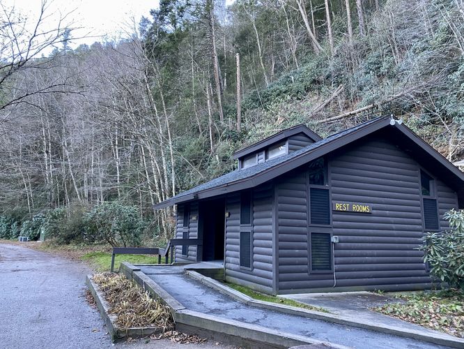
Restrooms
As of November 2023, there are non-flush restrooms located to the south of the parking lot along the D&L Trail.
Water Source
As of November 2023, there's a potable water station near the restrooms located to the south of the parking lot along the D&L Trail.
Trails
This hike follows one named trail: D&L Trail.
Universal Accessibility
The D&L Trail is universally-accessible and is accessible all the way to the viewing area for Luke's Falls.
Hike Description
This trail begins at the main parking lot for the Lehigh Gorge State Park Rockport Access. The main trail that hikers will follow is the D&L Trail which can be found on the Eastern side of the parking lot. The trail runs the length of the Lehigh Gorge, but this out-and-back hike follows a short segment. Hikers will walk South along the D&L Trail to head toward Luke's Falls. Along the way are non-flush restrooms and a seasonal potable water station.
Lehigh River & Gorge View - Mile 0.1
Around mile 0.1, hikers will pass an off-shoot trail that leads down to massive boulders that sit along the edge of the Lehigh River. Here, you can get a nice view of the Lehigh River and Lehigh Gorge.
After passing the view, hikers will be back on the flat universally-accessible D&L Trail as it makes its way south through the Lehigh Gorge. Hikers will pass many old rhododendron on their way to Luke's Falls.
Luke's Falls - Mile 0.3
Around mile 0.3, hikers will reach the ~20-foot tall Luke's Falls. The viewing area for Luke's Falls is directly on-trail and the waterfall is essentially in your face. There's very little space between Luke's Falls and the bridge that spans its creek, so getting a nice photograph is really tough. Additionally, Luke's Falls is mostly covered by old rhododendron that stretch out across the creek, obstructing the view of the waterfall. From the trail, hikers will be able to see about 20-feet of Luke's Falls, a lot of which are high-pitched slide waterfalls, so the cascade is fairly quiet. On topo maps, high above the trail in the gorge is a ledge where Luke's Falls spills down from above -- however, there's no safe way to reach that ledge and thus Luke's Falls remains partially hidden from public viewing.
The walk out follows the same path to complete this hike for 0.6-miles. While in the area, you might want to consider checking out Buttermilk Falls, Buck Mountain Falls, or even the Rockport Mine Tunnel.
Parking
Hikers will find a large parking lot at the coordinates provided, located at the end of Rockport Road in Weatherly. The lot is large enough to fit a couple dozen vehicles.
Pets
Dogs are allowed only if leashed and must be cleaned up after.
Restrooms
As of November 2023, there are non-flush restrooms located to the south of the parking lot along the D&L Trail.
Water Source
As of November 2023, there's a potable water station near the restrooms located to the south of the parking lot along the D&L Trail.