Buttermilk Falls at Lehigh Gorge State Park near Weatherly, Pennsylvania is an easy universally-accessible 0.7-mile out-and-back hike that leads to the 50-foot tall multi-tiered waterfall, Buttermilk Falls.
Trails
This hike follows one named trail: D&L Trail.
Universal Accessibility
The D&L Trail is universally-accessible and is accessible all the way to the viewing area for Buttermilk Falls.
Hike Description
This trail begins at the main parking lot for the Lehigh Gorge State Park Rockport Access. The main trail that hikers will follow is the D&L Trail which can be found on the Eastern side of the parking lot. The trail runs the length of the Lehigh Gorge, but this out-and-back hike follows a short segment. Hikers will hike North, first crossing a bridge that spans Buck Mountain Creek, then will pass a boat launch for white water rafting in the Lehigh River. The trail's also surrounded by tall rock ledges and provides neat gorge scenery for hikers pretty much right out of the gate. The trail then runs flat along the Lehigh River to reach Buttermilk Falls located further down the gorge.
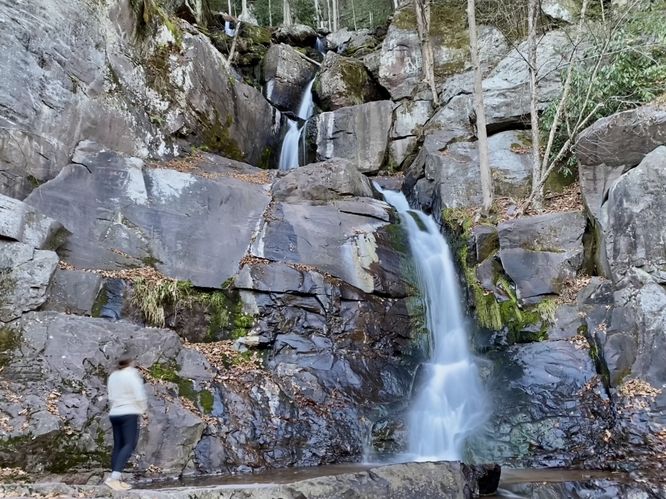
Buttermilk Falls - Mile 0.34
Around mile 0.34, hikers will reach the 50-foot tall multi-tiered waterfall known as Buttermilk Falls. The waterfall can be viewed easily from the trail or if you choose, you can hike down the rocks to reach the base of the waterfall for a different view. Buttermilk Falls is about 50-feet tall in total but cascades down several different tiers amongst the bedrock of the Lehigh Gorge. This waterfall is impressive and one of the more popular waterfalls to hike to in the area due to its ease of accessibility.
The walk out follows the same path to complete this hike for 0.7-miles. While in the area, you might want to consider checking out Luke's Falls, Buck Mountain Falls, or even the Rockport Mine Tunnel.
Parking
Hikers will find a large parking lot at the coordinates provided, located at the end of Rockport Road in Weatherly. The lot is large enough to fit a couple dozen vehicles.
Pets
Dogs are allowed only if leashed and must be cleaned up after.
Restrooms
As of November 2023, there are non-flush restrooms located to the south of the parking lot along the D&L Trail.
Water Source
As of November 2023, there's a potable water station near the restrooms located to the south of the parking lot along the D&L Trail.
Trails
This hike follows one named trail: D&L Trail.
Universal Accessibility
The D&L Trail is universally-accessible and is accessible all the way to the viewing area for Buttermilk Falls.
Hike Description
This trail begins at the main parking lot for the Lehigh Gorge State Park Rockport Access. The main trail that hikers will follow is the D&L Trail which can be found on the Eastern side of the parking lot. The trail runs the length of the Lehigh Gorge, but this out-and-back hike follows a short segment. Hikers will hike North, first crossing a bridge that spans Buck Mountain Creek, then will pass a boat launch for white water rafting in the Lehigh River. The trail's also surrounded by tall rock ledges and provides neat gorge scenery for hikers pretty much right out of the gate. The trail then runs flat along the Lehigh River to reach Buttermilk Falls located further down the gorge.
Buttermilk Falls - Mile 0.34
Around mile 0.34, hikers will reach the 50-foot tall multi-tiered waterfall known as Buttermilk Falls. The waterfall can be viewed easily from the trail or if you choose, you can hike down the rocks to reach the base of the waterfall for a different view. Buttermilk Falls is about 50-feet tall in total but cascades down several different tiers amongst the bedrock of the Lehigh Gorge. This waterfall is impressive and one of the more popular waterfalls to hike to in the area due to its ease of accessibility.
The walk out follows the same path to complete this hike for 0.7-miles. While in the area, you might want to consider checking out Luke's Falls, Buck Mountain Falls, or even the Rockport Mine Tunnel.
Parking
Hikers will find a large parking lot at the coordinates provided, located at the end of Rockport Road in Weatherly. The lot is large enough to fit a couple dozen vehicles.
Pets
Dogs are allowed only if leashed and must be cleaned up after.
Restrooms
As of November 2023, there are non-flush restrooms located to the south of the parking lot along the D&L Trail.
Water Source
As of November 2023, there's a potable water station near the restrooms located to the south of the parking lot along the D&L Trail.