Long Branch Falls at Tioga State Forest near Cedar Run, Pennsylvania is a moderate 0.7-mile out-and-back trail that leads to a beautiful 8-foot waterfall along Long Branch creek and follows the Honagha Danju Gawisay Trail.
This section of the Long Branch Trail is just a short portion of the much longer trail that consists of six different trails at Tioga State Forest, including the Honagha Danju Gawisay Trail.
The hike begins at the main trailhead along Mine Hole Road - hiking up the steep hillside initially. After hiking up to the trailhead sign, the trail takes a sharp right-hand turn and runs atop a steep hillside before following Cedar Run from a distance.
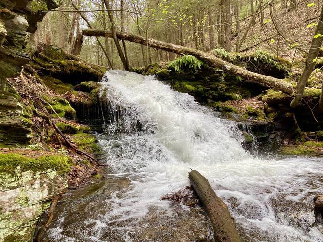
Not long after hiking adjacent to Cedar Run, the trail will head uphill along Long Branch creek. About 200-feet up from the start of the hike up Long Branch, hikers will find the scenic Long Branch Falls. This waterfall is about 8-feet tall and spills down across the trail. Our trail map ends here as we did not cross Long Branch to continue the hike; however, according to this state forest guide, the trail crosses Long Branch several times. In high water (early Spring), this creek can be dangerous because of the strong currents.
Long Branch Falls
The waterfall is broken up into two falls that's separated by the Long Branch Trail / Honagha Danju Gawisay Trail. The main section of the waterfall is about 8-feet tall that spills water down and onto the Long Branch Trail. Just below the trail creek crossing is a much shorter waterfall, about 3-feet tall. Further down the creek are several other small waterfalls about the same size.
Trail Names
This trail follows the Honagha Danju Gawisay Trail, which is part of the Long Branch Trail. Honagha Danju Gawisay is Native American for "water is flowing fast". The Honagha Danju Gawisay Trail is the technical name for this trail as the Long Branch Trail is made up of several different trails, including this one. The other trails that make up the Long Branch Trail are the Vanaimes Trail, Tumbling Run Trail, Buskirk Trail, Huck Trail, and Benole Trail (not displayed on this map).
Parking
Hikers can find parking at the coordinates provided. The parking lot is large enough to accommodate about 4 vehicles.
Pets
Dogs are allowed if leashed.
Blaze Color
This trail follows red blazes as of May, 2020.
Camping and Backpacking
Backpackers can camp along this trail, but must follow the Tioga State Forest primitive/dispersed/backcountry camping rules. Please note that there were no pre-built campsites along this section of the trail during May, 2020 but there are plenty of sections where a camp could be setup along Cedar Run.
Warning
Steep terrain: Hiking up the hill from Mile Hole Road is a bit of a challenge since the trail follows a very steep hillside. Furthermore, there are several steep and narrow sections of trail along this hike. During rainy seasons the creek can be very strong and dangerous, so hike at your own risk.
Rattlesnakes: While rare, the Timber Rattlesnake lives in this area and tends to come down to creeks to cool down or hunt between the end of April through the end of September. Watch your step and give any rattlesnake you see some space.
Winter Road Conditions
Tioga State Forest does not maintain this road during the winter. Do not attempt driving on this road without proper equipment including snow tires and/or chains unless the road is clear. High wind storms may also cause trees to fall across the road, making the road impassible. If you plan to visit during the winter, plan accordingly.
This section of the Long Branch Trail is just a short portion of the much longer trail that consists of six different trails at Tioga State Forest, including the Honagha Danju Gawisay Trail.
The hike begins at the main trailhead along Mine Hole Road - hiking up the steep hillside initially. After hiking up to the trailhead sign, the trail takes a sharp right-hand turn and runs atop a steep hillside before following Cedar Run from a distance.
Not long after hiking adjacent to Cedar Run, the trail will head uphill along Long Branch creek. About 200-feet up from the start of the hike up Long Branch, hikers will find the scenic Long Branch Falls. This waterfall is about 8-feet tall and spills down across the trail. Our trail map ends here as we did not cross Long Branch to continue the hike; however, according to this state forest guide, the trail crosses Long Branch several times. In high water (early Spring), this creek can be dangerous because of the strong currents.
Long Branch Falls
The waterfall is broken up into two falls that's separated by the Long Branch Trail / Honagha Danju Gawisay Trail. The main section of the waterfall is about 8-feet tall that spills water down and onto the Long Branch Trail. Just below the trail creek crossing is a much shorter waterfall, about 3-feet tall. Further down the creek are several other small waterfalls about the same size.
Trail Names
This trail follows the Honagha Danju Gawisay Trail, which is part of the Long Branch Trail. Honagha Danju Gawisay is Native American for "water is flowing fast". The Honagha Danju Gawisay Trail is the technical name for this trail as the Long Branch Trail is made up of several different trails, including this one. The other trails that make up the Long Branch Trail are the Vanaimes Trail, Tumbling Run Trail, Buskirk Trail, Huck Trail, and Benole Trail (not displayed on this map).
Parking
Hikers can find parking at the coordinates provided. The parking lot is large enough to accommodate about 4 vehicles.
Pets
Dogs are allowed if leashed.
Blaze Color
This trail follows red blazes as of May, 2020.
Camping and Backpacking
Backpackers can camp along this trail, but must follow the Tioga State Forest primitive/dispersed/backcountry camping rules. Please note that there were no pre-built campsites along this section of the trail during May, 2020 but there are plenty of sections where a camp could be setup along Cedar Run.
Warning
Steep terrain: Hiking up the hill from Mile Hole Road is a bit of a challenge since the trail follows a very steep hillside. Furthermore, there are several steep and narrow sections of trail along this hike. During rainy seasons the creek can be very strong and dangerous, so hike at your own risk.
Rattlesnakes: While rare, the Timber Rattlesnake lives in this area and tends to come down to creeks to cool down or hunt between the end of April through the end of September. Watch your step and give any rattlesnake you see some space.
Winter Road Conditions
Tioga State Forest does not maintain this road during the winter. Do not attempt driving on this road without proper equipment including snow tires and/or chains unless the road is clear. High wind storms may also cause trees to fall across the road, making the road impassible. If you plan to visit during the winter, plan accordingly.