The Vanaimes Trail and Waterfalls at Tioga State Forest near Cedar Run, Pennsylvania is a moderate 2.2-mile out-and-back hike that features countless waterfalls within Hamlin Hollow including Twin Falls, Moss Carpet Falls, several 6 to 8-foot tall rock slide waterfalls, and leads through a mountain hollow littered in glacial deposits which create a unique landscape.
14 Waterfalls
This Vanaimes Trail guide includes 14 different waterfalls; however, Hamlin Hollow's creek includes a countless number of very small cascades between 1 and 2-feet tall. It was impracticable to document all of them, hence the 14, including the largest, Twin Falls located at mile 0.35. To visit some of these waterfalls from their base, hikers will have to off-trail; however, they're visible from the trail too.
Trails
This hike follows one name trail: Vanaimes Trail (red blazes).
Hike Description
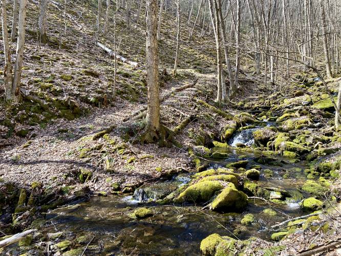
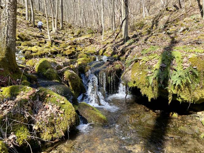
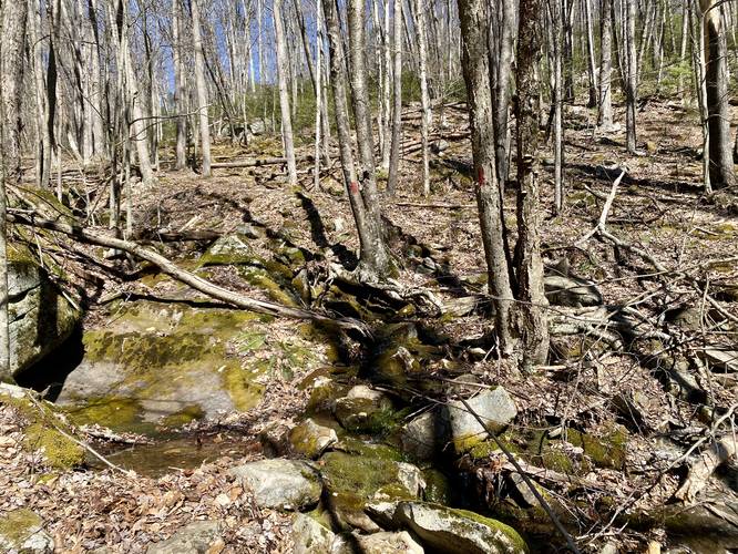
This hike begins at the eastern trailhead for the Vanaimes Trail located near the junction of Leetonia Road and Mine Hold Road near Cedar Run. The trail begins at a moderate grade and, for the most part, stays that way for the entire hike with minimal exceptions. The trail heads north, first passing through a forest of mountain laurel, before it bends west as it ascends the mountain through Hamlin Hollow. As the trail makes its bend, hikers will get views of waterfalls from the trail, starting around mile 0.3.
Waterfalls - Mile 0.3 to 0.35
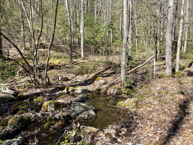
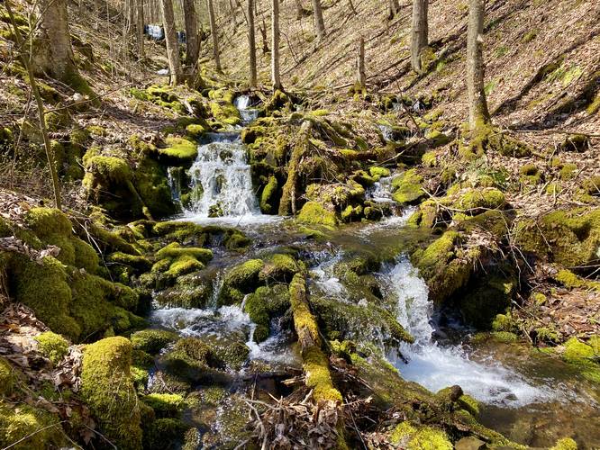
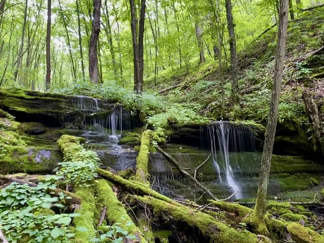
From mile 0.3 to 0.35 are several waterfalls in the creek below the trail. You can enjoy them from the trail or head down the steep shale rock-filled landscape (be very careful) to reach their base. The two best of the waterfalls in this section is a ~3-foot cascade that flows down the creek surrounded by several moss-covered rocks. There's also a 6-foot slide waterfall, covered in moss, here as well which I found to be really scenic.
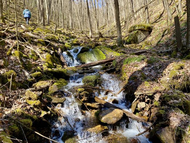
Twin Falls - Mile 0.35
Around mile 0.35, hikers will reach the largest waterfall along the trail, Twin Falls. Twin Falls cascades in two separate but similar cascades over a ~8 foot tall and 20-foot wide rock ledge. The rock ledge that plunges Twin Falls is not a sheer drop-off, but rather has a couple of steps within the bedrock. The trail skirts Twin Falls on the left-hand side. Note that if you don't care much about small 2-4 foot tall plunge or 8-foot tall slide waterfalls, the cascades above Twin Falls are not going to be exciting for you and thus turning around at Twin Falls is your best bet; however, the interesting landscape above Twin Falls, in my opinion, is worth hiking to. Also note that the trail substrate changes to a more annoying rocky terrain above Twin Falls, which makes the hiking a bit slower.
Creek Crossings - Mile 0.35 to 0.355
Immediately after reaching the top of Twin Falls, hikers will have to cross Hamlin Hollow Creek two times in a row to reach a steep hillside. The steep hillside hike lasts for about 25-vertical feet and is the hardest section of the Vanaimes Trail.
Creek Crossing - Mile 0.43
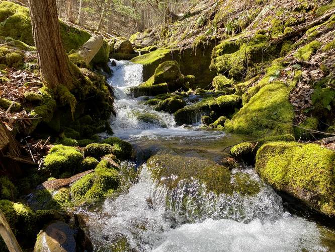
Around mile 0.43, hikers will reach another creek crossing. This one wasn't very difficult even in early April 2023. Between Twin Falls and this creek crossing is a nice 4.5-foot tall waterfall.
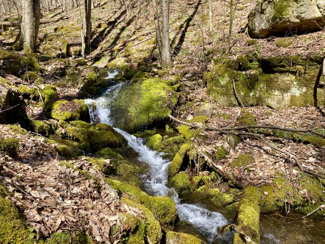
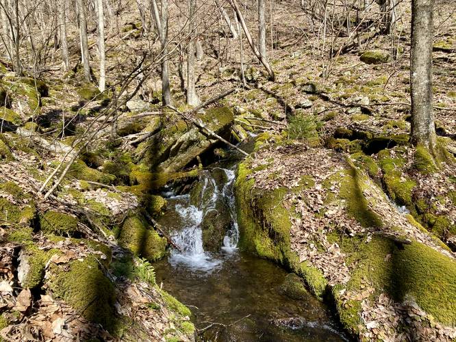
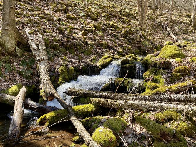
Moss Carpet Falls - Mile 0.46
After the 3rd creek crossing, hikers will reach the 3-foot tall and ~15-foot long Moss Carpet Falls. Moss Carpet Falls is a unique waterfall in that it's part slide and part plunge - the 15-foot lead on the long flat rock flows over a full moss-covered surface, hence "Moss Carpet Falls".
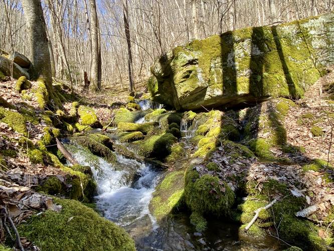
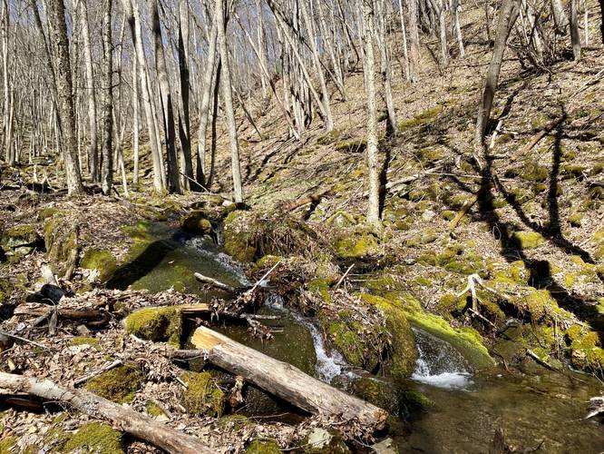
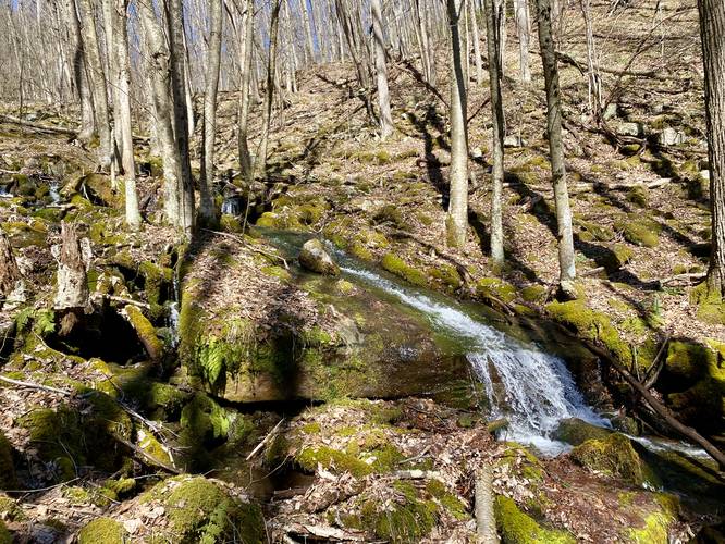
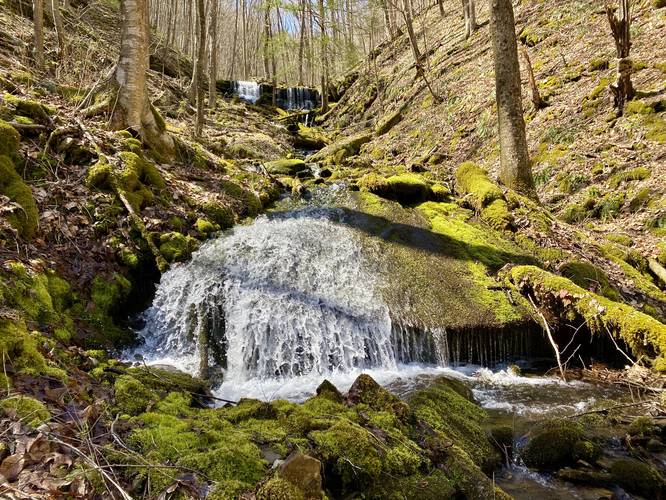
Waterfalls - Mile 0.5 to 0.7
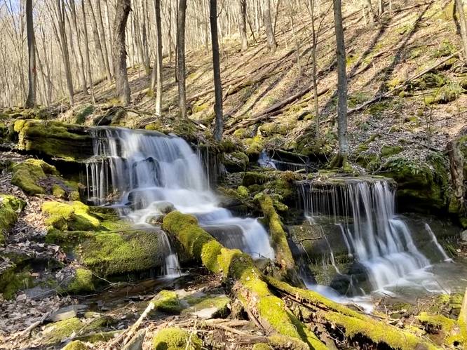
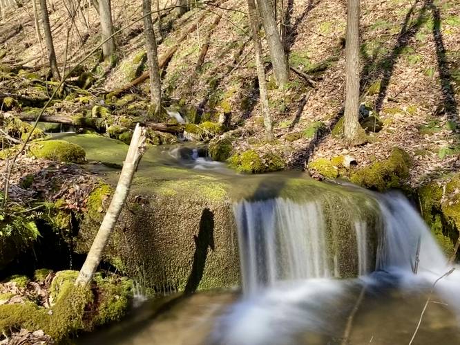
From mile 0.5 to 0.7, above Moss Carpet Falls, there are a multitude of waterfalls along the trail, located slightly off-trail and require just an additional 20-30 feet of hiking each to reach. I documented 8 of these waterfalls which I felt were worth-while checking out. Each in order heading up the mountain from Moss Carpet Falls: 5-foot tall tumbling waterfall, 6-foot tall multi-tiered slide fall, 3-foot tall tumbling falls adjacent to a massive glacial deposit, 3-foot tall cascade that spills out from below a large boulder, 2-foot tall cascade, 4-foot tall slide waterfall, 5-foot tall slide waterfall, and last an 8-foot tall slide waterfall with a 2-foot plunge at its base. I did not name all of these for various reasons.
Creek Disappears / Creek Crossing - Mile 0.7 to 0.9
Note that from mile 0.7, or slightly after, the creek tends to "disappear" a bit as it flows through the glacial deposits under your feet. Just before the creek crossing at mile 0.75, if you stop to listen to the water away from the main creek, it will sound like a rainstorm - really it's the water echoing below your feet. If you look around the large rocks a bit (be careful and watch your footing), you can actually find pools of water flowing under these large rocks. After the creek crossing, this continues for about another 0.15 miles as the creek flows under this large deposit of boulders. Also note that there are many mountain springs that spill their, potentially seasonal, waters out of random pockets in the ground that flow into the main creek of Hamlin Hollow. This landscape, as mentioned earlier in the write-up, is fairly unique for this area. This might be the last really-interesting section of this trail; however, the GPS track keeps going.
Creek Crossing - Mile 0.94
Around mile 0.94 hikers will reach the last creek crossing, on the ascent, which quickly leads into a more open forest with evergreen trees and, during warm months, tall grasses.
Tumbling Run Trail Junction / Turn Around Point - Mile 1.1
At mile 1.1, hikers will reach a junction with the Tumbling Run Trail which also follow red blazes. The Vanaimes Trail, at this junction, heads due-west from here; however, as of April 2023, that section of the trail is a bit overgrown and hasn't been maintained in a while. Here, we turned around. The forest floor is mostly open here due to the evergreen forest filled with hemlocks, white pine, and some Norwegian spruce.
Hiking Out
The hike out is a bit faster than the hike in; however, the rocky terrain can slow you down a bit. Watch your step, especially around the sections of trail that can be a bit over-taken by the creek or at creek crossings which can be slippery. Last, some don't forget to enjoy the numerous waterfalls on the way out.
Parking
Hikers will find a small parking turnout at the coordinates provided near the junction of Leeonia Road and Mine Hole Road. There's a larger parking turnout closer to Mine Hole Road if this parking turnout is fill.
Pets
Dogs are allowed if leashed and must be cleaned up after.
Camping and Backpacking
While there are no campsites on this trail, Tioga State Forest allowed primitive / dispersed / backcountry camping based on their rules and regulations. Backpackers may be able to setup a campsite near mile 1, where the terrain begins to flatten out at the top of the mountain, and where there's an open forest floor due to the evergreens. Please follow all state forest rules and regulations if camping.
Biking
While biking is technically allowed along this trail, it's not a great mountain biking trail due to the rocky substrate and steep hillsides.
Warning
Timber Rattlesnake: This area is known to inhabit the Timber Rattlesnake. Between April and October, rattlers can be found roaming the woods or hunting and drinking near creeks. Be on the lookout and watch out for rattles - give any you find plenty of space.
Rocky terrain: This rocky terrain can be a bit annoying for on-trail hiking. Additionally, if you go off-trail to explore waterfalls, the terrain can be holey where you feet might step into rocky crevasses covered by leaves. Also note the steep terrain covered in shale rocks that can be dangerous too.
14 Waterfalls
This Vanaimes Trail guide includes 14 different waterfalls; however, Hamlin Hollow's creek includes a countless number of very small cascades between 1 and 2-feet tall. It was impracticable to document all of them, hence the 14, including the largest, Twin Falls located at mile 0.35. To visit some of these waterfalls from their base, hikers will have to off-trail; however, they're visible from the trail too.
Trails
This hike follows one name trail: Vanaimes Trail (red blazes).
Hike Description
This hike begins at the eastern trailhead for the Vanaimes Trail located near the junction of Leetonia Road and Mine Hold Road near Cedar Run. The trail begins at a moderate grade and, for the most part, stays that way for the entire hike with minimal exceptions. The trail heads north, first passing through a forest of mountain laurel, before it bends west as it ascends the mountain through Hamlin Hollow. As the trail makes its bend, hikers will get views of waterfalls from the trail, starting around mile 0.3.
Waterfalls - Mile 0.3 to 0.35
From mile 0.3 to 0.35 are several waterfalls in the creek below the trail. You can enjoy them from the trail or head down the steep shale rock-filled landscape (be very careful) to reach their base. The two best of the waterfalls in this section is a ~3-foot cascade that flows down the creek surrounded by several moss-covered rocks. There's also a 6-foot slide waterfall, covered in moss, here as well which I found to be really scenic.
Twin Falls - Mile 0.35
Around mile 0.35, hikers will reach the largest waterfall along the trail, Twin Falls. Twin Falls cascades in two separate but similar cascades over a ~8 foot tall and 20-foot wide rock ledge. The rock ledge that plunges Twin Falls is not a sheer drop-off, but rather has a couple of steps within the bedrock. The trail skirts Twin Falls on the left-hand side. Note that if you don't care much about small 2-4 foot tall plunge or 8-foot tall slide waterfalls, the cascades above Twin Falls are not going to be exciting for you and thus turning around at Twin Falls is your best bet; however, the interesting landscape above Twin Falls, in my opinion, is worth hiking to. Also note that the trail substrate changes to a more annoying rocky terrain above Twin Falls, which makes the hiking a bit slower.
Creek Crossings - Mile 0.35 to 0.355
Immediately after reaching the top of Twin Falls, hikers will have to cross Hamlin Hollow Creek two times in a row to reach a steep hillside. The steep hillside hike lasts for about 25-vertical feet and is the hardest section of the Vanaimes Trail.
Creek Crossing - Mile 0.43
Around mile 0.43, hikers will reach another creek crossing. This one wasn't very difficult even in early April 2023. Between Twin Falls and this creek crossing is a nice 4.5-foot tall waterfall.
Moss Carpet Falls - Mile 0.46
After the 3rd creek crossing, hikers will reach the 3-foot tall and ~15-foot long Moss Carpet Falls. Moss Carpet Falls is a unique waterfall in that it's part slide and part plunge - the 15-foot lead on the long flat rock flows over a full moss-covered surface, hence "Moss Carpet Falls".
Waterfalls - Mile 0.5 to 0.7
From mile 0.5 to 0.7, above Moss Carpet Falls, there are a multitude of waterfalls along the trail, located slightly off-trail and require just an additional 20-30 feet of hiking each to reach. I documented 8 of these waterfalls which I felt were worth-while checking out. Each in order heading up the mountain from Moss Carpet Falls: 5-foot tall tumbling waterfall, 6-foot tall multi-tiered slide fall, 3-foot tall tumbling falls adjacent to a massive glacial deposit, 3-foot tall cascade that spills out from below a large boulder, 2-foot tall cascade, 4-foot tall slide waterfall, 5-foot tall slide waterfall, and last an 8-foot tall slide waterfall with a 2-foot plunge at its base. I did not name all of these for various reasons.
Creek Disappears / Creek Crossing - Mile 0.7 to 0.9
Note that from mile 0.7, or slightly after, the creek tends to "disappear" a bit as it flows through the glacial deposits under your feet. Just before the creek crossing at mile 0.75, if you stop to listen to the water away from the main creek, it will sound like a rainstorm - really it's the water echoing below your feet. If you look around the large rocks a bit (be careful and watch your footing), you can actually find pools of water flowing under these large rocks. After the creek crossing, this continues for about another 0.15 miles as the creek flows under this large deposit of boulders. Also note that there are many mountain springs that spill their, potentially seasonal, waters out of random pockets in the ground that flow into the main creek of Hamlin Hollow. This landscape, as mentioned earlier in the write-up, is fairly unique for this area. This might be the last really-interesting section of this trail; however, the GPS track keeps going.
Creek Crossing - Mile 0.94
Around mile 0.94 hikers will reach the last creek crossing, on the ascent, which quickly leads into a more open forest with evergreen trees and, during warm months, tall grasses.
Tumbling Run Trail Junction / Turn Around Point - Mile 1.1
At mile 1.1, hikers will reach a junction with the Tumbling Run Trail which also follow red blazes. The Vanaimes Trail, at this junction, heads due-west from here; however, as of April 2023, that section of the trail is a bit overgrown and hasn't been maintained in a while. Here, we turned around. The forest floor is mostly open here due to the evergreen forest filled with hemlocks, white pine, and some Norwegian spruce.
Hiking Out
The hike out is a bit faster than the hike in; however, the rocky terrain can slow you down a bit. Watch your step, especially around the sections of trail that can be a bit over-taken by the creek or at creek crossings which can be slippery. Last, some don't forget to enjoy the numerous waterfalls on the way out.
Parking
Hikers will find a small parking turnout at the coordinates provided near the junction of Leeonia Road and Mine Hole Road. There's a larger parking turnout closer to Mine Hole Road if this parking turnout is fill.
Pets
Dogs are allowed if leashed and must be cleaned up after.
Camping and Backpacking
While there are no campsites on this trail, Tioga State Forest allowed primitive / dispersed / backcountry camping based on their rules and regulations. Backpackers may be able to setup a campsite near mile 1, where the terrain begins to flatten out at the top of the mountain, and where there's an open forest floor due to the evergreens. Please follow all state forest rules and regulations if camping.
Biking
While biking is technically allowed along this trail, it's not a great mountain biking trail due to the rocky substrate and steep hillsides.
Warning
Timber Rattlesnake: This area is known to inhabit the Timber Rattlesnake. Between April and October, rattlers can be found roaming the woods or hunting and drinking near creeks. Be on the lookout and watch out for rattles - give any you find plenty of space.
Rocky terrain: This rocky terrain can be a bit annoying for on-trail hiking. Additionally, if you go off-trail to explore waterfalls, the terrain can be holey where you feet might step into rocky crevasses covered by leaves. Also note the steep terrain covered in shale rocks that can be dangerous too.