Loading...

Little Fall Branch Falls Hike

Directions
Map
Pictures
Send to App
Distance:
0.5 Miles / 0.8 km
Type:
Out-and-Back
Difficulty:
Easy
Time to Hike:
~15 minutes
Features:
Surface Type:
Dirt
Park:
Pisgah National Forest
Town:
Joe, North Carolina
Directions:
35.757865, -82.977521
Added:
March 13, 2025
Updated:
April 05, 2025
Copy Trail Link Hiking this trail? Send a friend or family member a link to this trail guide for your own safety. Hike at your own risk (disclaimer)
Loading...
Loading...
195'

Total Change
193'

Ascent
195'

Descent

Download the Trail Route for Offline Use

Supporters get exclusive access to download trail routes to the MyHikes app for offline use. Stay prepared on your adventure, even without an internet connection! Become a Supporter today to unlock this feature and hike with confidence.

Send to App

Little Fall Branch Falls Hike

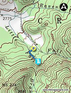
This short hike to Little Fall Branch Falls is worth a quick stop if you are hiking in the Harmon Den Wildlife Management Area of Pisgah National Forest. If you are hiking to Max Patch or having a nice outing at the Cold Springs Picnic Area, then this 30-minute detour will most certainly surprise you. Little Fall Branch is very tiny, and it seems impossible that an impressive waterfall would be located on this watercourse. The waterfall is ~40 feet high and hemmed in by a cove of moss-covered cliffs. It would at its most spectacular in the summer after rain when everything is really green. Although the trail to the waterfall is unofficial, the path is easy and appropriate for any hiker. Parking for the trail is located beside the gate on FR 3526/Fall Branch Rd just beyond the Cold Springs Picnic Area and the gated road for the Harmon Den Horse Camp.

  • Mile 0.0 – Walk beyond the gate on Fall Branch Rd crossing over the tiny Little Fall Branch. Approximately 10 feet past the gate look for a side trail on he left that follows the stream. This is an unofficial path to the waterfall. If you can’t find it initially just follow Little Fall Branch upstream. The path rarely strays more than 15 feet from the creek and is easy to follow.

  • Mile 0.3 – Reach the base of Little Fall Branch Falls. The stream cascades down a steep slope then freefalls more than 30 feet. The cliffs around the waterfall are covered in thick moss.

  • Mile 0.5 – Hike ends at Fall Branch Rd.
By HikingUpward Contributor: Zach Robbins
Explore 22 trails near Joe, NC
  1. Parking

    35.757865, -82.977521
  2. Main Trailhead

    35.757865, -82.977521
No community routes found. To add your own hike as a Community Route for this Trail guide, leave a Trip Report with an attached GPX file.

Hazards

Snakes
Poison Ivy/Oak

Seasons

All

Trip Reports

Trail Guide By:
HikingUpward user profile picture
0.5 miles / 0.8 km

Weather Forecast

In Joe, NC

Explore Hiking Trails

You May Also Like

Colorado's Million Dollar Highway - Plan a day's drive adventure along the iconic Million Dollar Highway in Colorado. Explore the best short trails, roadside stops, waterfalls, vistas, ghost towns, and hot springs within a ~6 hour road trip.
Explore

Colorado's Million Dollar Highway

Plan a day's drive adventure along the iconic Million Dollar Highway in Colorado. Explore the best short trails, roadside stops, waterfalls, vistas, ghost towns, and hot springs within a ~6 hour road trip.

Read
Glacier's Going-to-the-Sun Road - Discover the breathtaking beauty of Glacier National Park along the iconic Going-to-the-Sun Road. From stunning roadside stops to picturesque waterfalls and vistas, this engineering marvel offers endless opportunities for exploration.
Explore

Glacier's Going-to-the-Sun Road

Discover the breathtaking beauty of Glacier National Park along the iconic Going-to-the-Sun Road. From stunning roadside stops to picturesque waterfalls and vistas, this engineering marvel offers endless opportunities for exploration.

Read
New York's Best Waterfalls - Whether you're planning a day hike, roadside stop, or a leisurely short walk, this guide provides hikers, travelers, and locals alike with 63 different locations to over 100 scenic waterfalls to help plan your next adventure!
Explore

New York's Best Waterfalls

Whether you're planning a day hike, roadside stop, or a leisurely short walk, this guide provides hikers, travelers, and locals alike with 63 different locations to over 100 scenic waterfalls to help plan your next adventure!

Read
25 Best Day Hikes in North Carolina - Discover the top 25 best day hikes in North Carolina, from breathtaking waterfalls to mountain peaks. Explore hidden gems, scenic views, and trails suitable for all skill levels, perfect for your next outdoor adventure.
Explore

25 Best Day Hikes in North Carolina

Discover the top 25 best day hikes in North Carolina, from breathtaking waterfalls to mountain peaks. Explore hidden gems, scenic views, and trails suitable for all skill levels, perfect for your next outdoor adventure.

Read

Before you boogie...

Find our trail guides useful? Consider becoming a Supporter to unlock perks!

MyHikes is an indie platform that makes exploring public trails easier for everyone. The platform has no investors, no ads, and is owned and operated by one person, Dave Miller. Dave has personally mapped and written over 1,800 trail guides on MyHikes for the public to explore. MyHikes has helped millions outdoor enthusiasts plan their next adventure.

But it takes a lot of time 🕦, money 💰, work, and espresso shots ☕ to run MyHikes, including hiking , mapping , writing , and publishing new trails with high-quality (accurate) information... along with software engineering (coding) the platform like building new features, website and mobile app development (iOS and Android), site maintainance . and much much more.

Supporters unlock website and mobile app perks with an annual one-time payment of $25 (you renew) 😎👍. Or you can simply make a Donation of your choice. Otherwise, you can support us by telling your friends about MyHikes - both quick and free 🎉

Admin user profile picture

Dave Miller
MyHikes Founder