Lambs Lookout at Tioga State Forest near Canton, Pennsylvania is an easy 1.1-mile out-and-back hike that leads to a vista atop Armenia Mountain that features views of Bradford County.
Hours
Note that Lambs Park is a small designated area within Tioga State Forest which is only open from dawn to dusk each day. The road gate is open for driving from May 20 through November 20th each year, according to the signage. During off-season, this area can be hiked-in as described.
Trail Description
This hike begins at the small triangular-shaped parking area outside of the yellow service gate located at the parking coordinates provided. The hike follows the service road all the way to the lookout, but there are some things to note along the way.
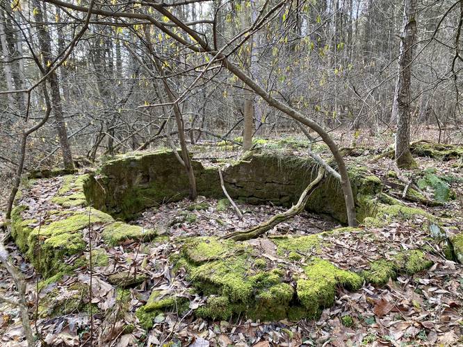
Old Farm Silo - Mile 0.1
At mile 0.1, on the left-hand (south) side of the trail, hikers may notice an old abandoned circular stone structure. There's a small beaten path that leads to this structure, which appears to be an old farm silo.
After passing the farm silo, hikers will continue following the road and passing a bisecting yellow-blazed Lambs Park Loop trail along the way.
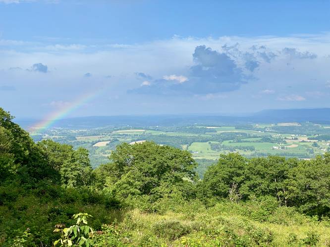
Lambs Lookout - Mile 0.55
Just after hikers pass the brown "Lambs Lookout" sign, they'll reach the vista they hiked out for. Lambs Lookout is a large open cutout that Tioga State Forest maintains regularly to keep this overlook open to the public. Lambs Lookout faces due-east that features views of the rolling hills of Bradford County in addition to the dramatic slopes of Naglee Mountain in the distance.
Parking
Hikers will find parking at the coordinates provided, located at the junction of Lambs Lookout Lane and Mountain Ave during off-season (Nov 20 - May 19) each year. If visiting between May 20 - Nov 20, this is not exactly a hike and you can drive right to the vista.
Pets
Dogs are allowed if leashed and their waste should be carried out by the hiker.
Camping and Backpacking
Tioga State Forest allowed camping and backpacking - specifically dispersed / primitive / backcountry camping; however, camping and backpacking are not allowed within the Lambs Lookout / Lambs Park region of Tioga State Forest. Please note that this "park" inside the state forest is not well-defined on the state forest map, but it's save to assume that no one should setup a campsite near or at Lambs Lookout or on any nearby trails like the Lambs Park Loop.
Hours
Note that Lambs Park is a small designated area within Tioga State Forest which is only open from dawn to dusk each day. The road gate is open for driving from May 20 through November 20th each year, according to the signage. During off-season, this area can be hiked-in as described.
Trail Description
This hike begins at the small triangular-shaped parking area outside of the yellow service gate located at the parking coordinates provided. The hike follows the service road all the way to the lookout, but there are some things to note along the way.
Old Farm Silo - Mile 0.1
At mile 0.1, on the left-hand (south) side of the trail, hikers may notice an old abandoned circular stone structure. There's a small beaten path that leads to this structure, which appears to be an old farm silo.
After passing the farm silo, hikers will continue following the road and passing a bisecting yellow-blazed Lambs Park Loop trail along the way.
Lambs Lookout - Mile 0.55
Just after hikers pass the brown "Lambs Lookout" sign, they'll reach the vista they hiked out for. Lambs Lookout is a large open cutout that Tioga State Forest maintains regularly to keep this overlook open to the public. Lambs Lookout faces due-east that features views of the rolling hills of Bradford County in addition to the dramatic slopes of Naglee Mountain in the distance.
Parking
Hikers will find parking at the coordinates provided, located at the junction of Lambs Lookout Lane and Mountain Ave during off-season (Nov 20 - May 19) each year. If visiting between May 20 - Nov 20, this is not exactly a hike and you can drive right to the vista.
Pets
Dogs are allowed if leashed and their waste should be carried out by the hiker.
Camping and Backpacking
Tioga State Forest allowed camping and backpacking - specifically dispersed / primitive / backcountry camping; however, camping and backpacking are not allowed within the Lambs Lookout / Lambs Park region of Tioga State Forest. Please note that this "park" inside the state forest is not well-defined on the state forest map, but it's save to assume that no one should setup a campsite near or at Lambs Lookout or on any nearby trails like the Lambs Park Loop.