The Knoll-Willows Overlook Trail at Knoll-Willows in Estes Park, Colorado is an easy 0.2-mile one-way trail that features views of Lake Estes, Mount Olympus, Mount Pisgah, the town of Estes Park, and the historic Stanley Hotel.
Walk
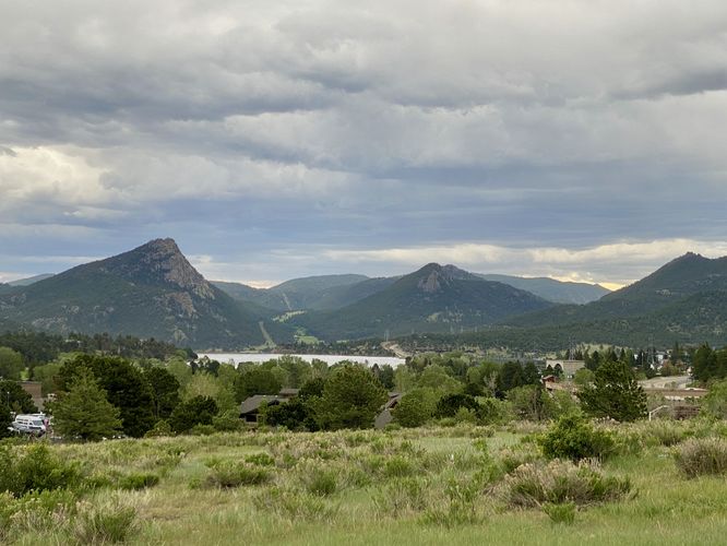
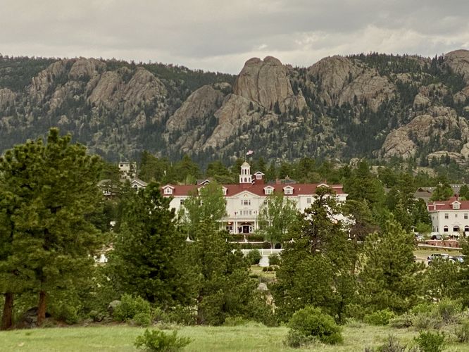
This is less of a hike and more of a short walk that leads up the hill from the main parking lot to several different viewpoints. The trail terminates at the Albert Birch Ruins and Cabin Trail adjacent to the Albert Birch Bungalow Ruins. The trail is relatively flat as it makes its way uphill at a gradual grade. Before the trail drops down to reach the Albert Birch Bungalow Ruins, you'll find beautiful views of Lake Estes and its surrounding mountains like Mount Olympus and Mount Pisgah in the background. To the north sits the historic Stanley Hotel, which is supposedly haunted, and was the inspiration for Steven King's, The Shining. The hotel sits below the gray bedrock cliffs of the Rocky mountains and if you're lucky you might hike the trail at a time when the hotel's hourly bell is rung at the top of the hour.
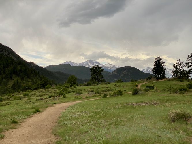
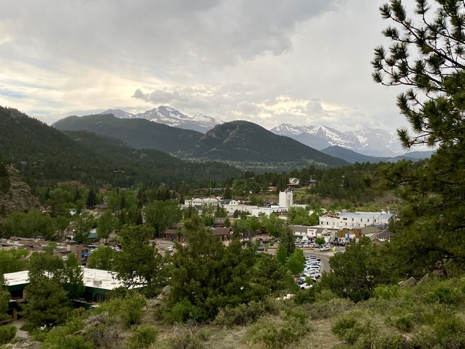
The trail terminates as you head downhill from the high-point. On your way down, you'll find nice views of Estes Park in addition to the Front Range of the Rocky Mountains within Rocky Mountain National Park. Hikers will find the Albert Birch Bungalow Ruins at the end of the trail -- here, you can hop on the Albert Birch Ruins and Cabin Trail to explore the ruins and the Albert Birch Cabin.
Parking
Hikers and visitors will find a small parking lot at the coordinates provided, located on the south side of East Wonderview Ave in Estes Park, CO. The lot is large enough to fit less than 10 vehicles as of June 2024.
Popularity
This is a popular spot for day hikers and visitors alike. Unless you show up early in the morning or late in the day, you may find difficulty parking as the lot is so small. There's a pathway that connects this park (from the cabin) to town for an alternative way to access the park; however, that route is not included in this data.
Pets
Dogs are not allowed at Knoll-Willows.
Walk
This is less of a hike and more of a short walk that leads up the hill from the main parking lot to several different viewpoints. The trail terminates at the Albert Birch Ruins and Cabin Trail adjacent to the Albert Birch Bungalow Ruins. The trail is relatively flat as it makes its way uphill at a gradual grade. Before the trail drops down to reach the Albert Birch Bungalow Ruins, you'll find beautiful views of Lake Estes and its surrounding mountains like Mount Olympus and Mount Pisgah in the background. To the north sits the historic Stanley Hotel, which is supposedly haunted, and was the inspiration for Steven King's, The Shining. The hotel sits below the gray bedrock cliffs of the Rocky mountains and if you're lucky you might hike the trail at a time when the hotel's hourly bell is rung at the top of the hour.
The trail terminates as you head downhill from the high-point. On your way down, you'll find nice views of Estes Park in addition to the Front Range of the Rocky Mountains within Rocky Mountain National Park. Hikers will find the Albert Birch Bungalow Ruins at the end of the trail -- here, you can hop on the Albert Birch Ruins and Cabin Trail to explore the ruins and the Albert Birch Cabin.
Parking
Hikers and visitors will find a small parking lot at the coordinates provided, located on the south side of East Wonderview Ave in Estes Park, CO. The lot is large enough to fit less than 10 vehicles as of June 2024.
Popularity
This is a popular spot for day hikers and visitors alike. Unless you show up early in the morning or late in the day, you may find difficulty parking as the lot is so small. There's a pathway that connects this park (from the cabin) to town for an alternative way to access the park; however, that route is not included in this data.
Pets
Dogs are not allowed at Knoll-Willows.