The Albert Birch Ruins and Cabin Trail at Knoll-Willows in Estes Park, Colorado is an easy 0.4-mile loop hike that features stunning views of Estes Park, the Rocky Mountains, and leads to a stone bungalow ruin and still-standing cabin, once owned by Albert Birch.
Hike
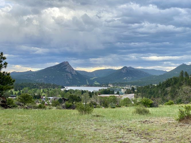
This very short hike begins at the main parking lot for the Centennial Open Space at Knoll-Willows and follows the center-most trail as it leads uphill and toward the Albert Birch Bungalow Ruins. The trail has a couple of benches and lookout points on the way up which provide views of Lake Estes, Mount Olympus, Mount Pisgah, and the historic Stanley Hotel (which was the inspiration for Steven King's, The Shining).
Albert Birch Bungalow Ruins - Mile 0.16
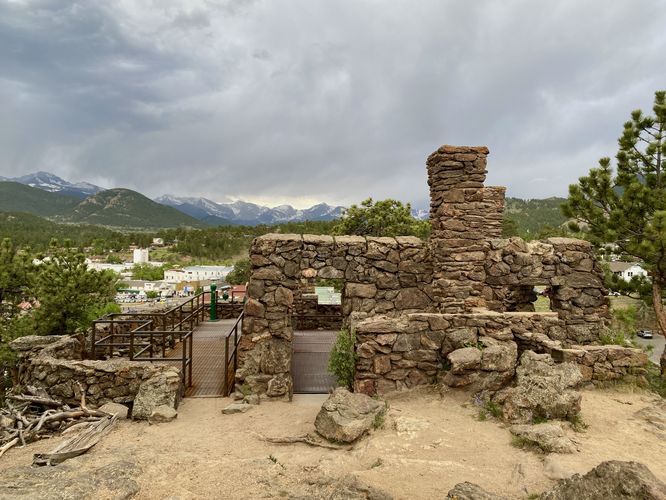
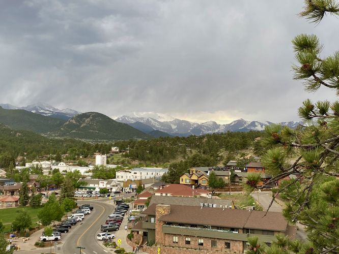
Once near the top of the hill, you'll notice the stone structure of the bungalow ruins, sitting on the side of the hill with a beautiful view of the downtown of Estes Park, CO. Here, you can learn more about this short-lived bungalow that was accidentally burnt to the ground in 1907, approximately 4 years after the bungalow was built in 1903. From the bungalow ruins, you'll find more information plaques along with stunning views of downtown Estes Park and the Front Range of the Rocky Mountains within Rocky Mountain National Park.
Albert Birch Cabin - Mile 0.3
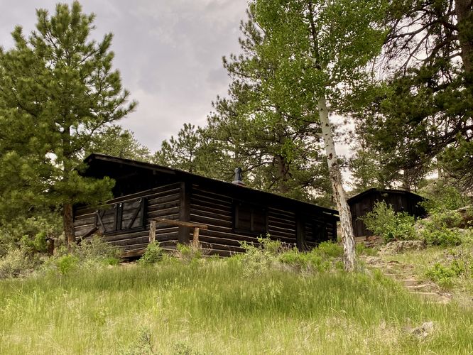
After exploring the bungalow ruins, you can follow the adjacent trail as it leads downhill toward the Albert Birch Cabin. The cabin sits around mile 0.3 in the route provided, with a backside view of the cabin and Estes Park in the background. You can hike the nearby trail, which leads into town, to get a better front-side view of the cabin. The Albert Birch Cabin was built after the bungalow was accidentally burnt down and was used until the 1980's by the Birch family. In 2001, the town of Estes Park acquired the land and now the land is operated and maintained by the Estes Valley Land Trust in addition to the town.
After exploring the cabin, the trail leads back to parking by following a short uphill walk heading northeast to complete the loop at 0.4-miles long.
Parking
Hikers and visitors will find a small parking lot at the coordinates provided, located on the south side of East Wonderview Ave in Estes Park, CO. The lot is large enough to fit less than 10 vehicles as of June 2024.
Popularity
This is a popular spot for day hikers and visitors alike. Unless you show up early in the morning or late in the day, you may find difficulty parking as the lot is so small. There's a pathway that connects this park (from the cabin) to town for an alternative way to access the park; however, that route is not included in this data.
Pets
Dogs are not allowed at Knoll-Willows.
Hike
This very short hike begins at the main parking lot for the Centennial Open Space at Knoll-Willows and follows the center-most trail as it leads uphill and toward the Albert Birch Bungalow Ruins. The trail has a couple of benches and lookout points on the way up which provide views of Lake Estes, Mount Olympus, Mount Pisgah, and the historic Stanley Hotel (which was the inspiration for Steven King's, The Shining).
Albert Birch Bungalow Ruins - Mile 0.16
Once near the top of the hill, you'll notice the stone structure of the bungalow ruins, sitting on the side of the hill with a beautiful view of the downtown of Estes Park, CO. Here, you can learn more about this short-lived bungalow that was accidentally burnt to the ground in 1907, approximately 4 years after the bungalow was built in 1903. From the bungalow ruins, you'll find more information plaques along with stunning views of downtown Estes Park and the Front Range of the Rocky Mountains within Rocky Mountain National Park.
Albert Birch Cabin - Mile 0.3
After exploring the bungalow ruins, you can follow the adjacent trail as it leads downhill toward the Albert Birch Cabin. The cabin sits around mile 0.3 in the route provided, with a backside view of the cabin and Estes Park in the background. You can hike the nearby trail, which leads into town, to get a better front-side view of the cabin. The Albert Birch Cabin was built after the bungalow was accidentally burnt down and was used until the 1980's by the Birch family. In 2001, the town of Estes Park acquired the land and now the land is operated and maintained by the Estes Valley Land Trust in addition to the town.
After exploring the cabin, the trail leads back to parking by following a short uphill walk heading northeast to complete the loop at 0.4-miles long.
Parking
Hikers and visitors will find a small parking lot at the coordinates provided, located on the south side of East Wonderview Ave in Estes Park, CO. The lot is large enough to fit less than 10 vehicles as of June 2024.
Popularity
This is a popular spot for day hikers and visitors alike. Unless you show up early in the morning or late in the day, you may find difficulty parking as the lot is so small. There's a pathway that connects this park (from the cabin) to town for an alternative way to access the park; however, that route is not included in this data.
Pets
Dogs are not allowed at Knoll-Willows.