Loading...

WINTER SALE! 50% OFF Supporter Accounts — now through January 31st. Learn More.

High Falls Hike

High Falls is one of the most beautiful waterfalls in the Monongahela, and at an altitude of over 2,800ft, one of the highest. The High Falls trail passes through old growth forest, and large hemlock as it winds through the saddle on Shavers Mountain. This is a beautiful hike in the backcountry of the Monongahela National Forest.

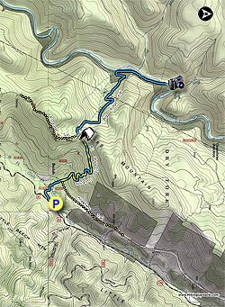
From the parking pull-out on FR44/Beulah Rd, walk 75 yards to the blue blazed/diamond High Falls trailhead. Follow the High Falls Trail for 0.2 miles and cross West Fork over a wooden footbridge. In another 0.3 miles the High Falls trail will join the Allegheny trail at an old access road.

Cross the access road and pass through a large field, as the now blue/yellow blazed Allegheny/High Falls trail climbs Shaver Mountain. In 1.2 miles from the field, arrive at the saddle on Shaver Mountain and the only good campsite on the hike (no water). Just past the campsite arrive at the intersection where the Allegheny Trail splits left.

Stay straight, now going downhill on the blue blazed High Falls trail and reach a small abandoned service road in 0.2 miles. Important: Turn right as the blue blazed trail now follows the service road (SR), and DOES NOT cross it. Follow the blue blazed SR for another 0.2 miles where the High Falls trail turns left off the SR downhill.

Follow the blue blazed High Falls trail for 1.1 miles where the trail arrives at the railroad tracks. Important: DO NOT descend the burn on the other side of the railroad tracks. Turn right, the High Falls trail will now follow beside the railroad tracks the remaining 0.9 miles to High Falls. DO NOT walk in the center of the tracks, and pay extra attention for trains.

High Falls is a stopping point for a scenic rail tour, and it's possible that when you arrive at the depot hut, and High Falls, there are a group of people. If a scenic tour passes make sure to wave to the passengers, as they'll be wondering where you came from :)

At the small depot and High Falls, follow the trail as it heads to either the upper or lower viewpoint. High Falls is horseshoe shaped, and over 100ft wide, falling 20ft into a large pool below.

To return, retrace your route back over Shavers Mountain. Be extra cautious listening for trains on the return route, as they generally approach from the north at your back.

Explore 36 trails near Glady, WV

Know Before You Go

  • The High Falls Hike in Glady, WV is a 7.4-mile roundtrip trail to a notable waterfall in the Monongahela National Forest, featuring old-growth forests and high altitudes.
  • The trail involves multiple intersections, road sections (including a service road and railroad tracks), and requires careful attention to blazes and directional changes to avoid getting lost.
  • High Falls is a popular destination, possibly crowded due to a scenic rail tour stop; hikers should be prepared to share the viewpoint and exercise caution around the railroad tracks, especially on the return journey.
Interactive topographic map for High Falls Hike located in Glady, WV. Click the "View Map" button to load GPS coordinates and trail markers.
Get directions
Distance
7.4 mi
Difficulty
Moderate
Type
Out-and-Back
Est. Time
3.7 hrs
Elev. Gain
1,366'
Rating
4.4
Added
March 16, 2025
Updated
April 05, 2025

Weather Forecast

Loading...
Total Change
730'
Ascent
1,366'
Descent
1,368'
Loading...

Download the GPX Data for Offline Use

Supporters get exclusive access to download trail routes to the MyHikes app for offline use. Stay prepared on your adventure, even without an internet connection! Become a Supporter today to unlock this feature and hike with confidence.

Download High Falls Hike GPX Data to the MyHikes Mobile App

Features

Vista / Lookout Point
Dogs
Waterfalls
Camping
Water Source

Points of interest

  1. Parking

    38.750003, -79.752145
  2. Main Trailhead

    38.749983, -79.752545

Safety information

For your own safety: plan ahead, let someone know where you'll be, and hike at your own risk.

Hazards

Snakes (Rattlesnakes, Copperheads, others)
Poison Ivy or Poison Oak

Markers

Blaze Color

Blue

Availability

All seasons

Surface type

Dirt

Trip Reports (Reviews)

Rated 4.36 out of 5 based on 14 ratings.

Ready to help fellow hikers? Add a trip report to share your experience and provide valuable insights for other hikers!

By: John Rogers
7.4 miles / 11.9 km
August 18, 2018
My lady and I did this hike over the past weekend. We hiked out to a fabulous campsite by the river about a half mile from the falls and spent the night. The trail is in great shape along the way and the fishing looked like it would be excellent down around where we camped. We both loved it and recommend it to anyone looking for a quick get away.
Legacy Review
By: cpo
7.4 miles / 11.9 km
January 22, 2017
This is an excellent out/back hike, especially off-season. We found it to be very well marked, so perhaps it's been re-blazed since the previous reviewers. We are generally fit but not speed hikers, and we took about 3:30 out/back, and another 45 minutes for lunch at the falls (4.15 total time). We found the grade to be steady. The steepest stretches were a short section right as you leave the meadow nearest the trail head, and then right as you drop onto the river. Lots of switchbacks made for a mellow grade otherwise, and we found the elevation summary pretty accurate. We had the entire hike to ourselves, but can easily see how it could be quite busy on a nice warm day in high season. There were a lot of seeps so plenty of water if you run out, and we enjoyed the picnic benches down at the depot/river. There's also been a lot of work to build a staircase, etc., looks pretty new (just this past season?). We had lunch right at the base of the falls and enjoyed the cool spray. The only negative to the hike is that there isn't much of a trail next to the rail bed, but that's a pretty minor thing. We're also guessing it would be a little tricky in icy weather. Laslty, it was a little further drive from Alpena than we were expecting, but that may say more about our map skills than about the info on this website. Thanks to all who have had a hand in this website, including previous reviewers!
Legacy Review
By: Peter
7.4 miles / 11.9 km
August 06, 2016
This is an EPIC hike. Out of my top 10 hikes, this one is now #2. Abdolutely beautiful scenery. ENOURMOUS mushrooms abound. The ascents are not too hard, and there are very few rocky areas, and a few muddy spots. There was also an abundance of blackberries. We arrived at the falls just as the Durbin express was unloading, so we even got a few pictures with the train. The falls were very full and every bit of the 10 of 10 that my West Virginia waterfalls book gave them for beauty. Below the falls is a HUGE swimming hole, and at 6'3 the water went way over my head. It was every bit of a wonderful experience. There are a few detractors in this hike. They are: 1. The blue trail markers are few and far between a few miles into the hike. Forrunately the intersections are typically well marked. 2. The rock is UNBELIEVABLY SLICK above the falls. I slid on my butt to get to the other side. The rocks are also very slick getting into the swimming hole. 3. The port-a-potties they have there were nasty and you can smell them from 50 yards away. 4. It is very wet there, making the rocks very slick. Travel slow in rocky areas. I am currently at the Emergency Room in Petersburg because my friend fell and cracked open her head. It is not wise to hike very fast. Aside from those things, this hike was phenomenal. If it wasn't so far away from home, Id come here every week.
Legacy Review
No community routes found. To add your own hike as a Community Route for this Trail guide, leave a Trip Report with an attached GPX file.

Popular categories

Scenic mountain view representing vista trails
Vista trails
Scenic gorge of cascades representing waterfall trails
Waterfall hikes
Rugged mountain terrain representing summit trails
Summit trails
Scenic mountain view representing dog-friendly trails
Dog-friendly
Scenic campsite with a view representing camping trails
Camping trails
Appalachian Trail logo representing A.T. hikes
A.T. hikes

You May Also Like

Colorado's Million Dollar Highway - Plan a day's drive adventure along the iconic Million Dollar Highway in Colorado. Explore the best short trails, roadside stops, waterfalls, vistas, ghost towns, and hot springs within a ~6 hour road trip.
Explore

Colorado's Million Dollar Highway

Plan a day's drive adventure along the iconic Million Dollar Highway in Colorado. Explore the best short trails, roadside stops, waterfalls, vistas, ghost towns, and hot springs within a ~6 hour road trip.

Read
🍪 We use cookies to learn about site usage and to serve map tiles. You may block cookies manually in the browser. By continuing you agree. Learn more