Loading...

๐ŸŽ‰ Enjoy a Free 7-Day Supporter Trial and Unlock Exclusive Perks โ€” No Credit Card Required. Learn more.

Hidden Lake Trail to Overlook

Directions
Map
Pictures
Send to App
Distance:
2.7 Miles / 4.3 km
Type:
Out-and-Back
Difficulty:
Moderate
Time to Hike:
1 hour, ~21 minutes
Features:
Surface Type:
Boardwalk
Park:
Glacier National Park
Town:
Saint Mary, Montana
Directions:
48.695763, -113.717544
Added:
September 17, 2024
Updated:
January 19, 2025
Copy Trail Link Hiking this trail? Send a friend or family member a link to this trail guide for your own safety. Hike at your own risk (disclaimer)
Loading...
Loading...
521'

Total Change
606'

Ascent
606'

Descent

Download the Trail Route for Offline Use

Supporters get exclusive access to download trail routes to the MyHikes app for offline use. Stay prepared on your adventure, even without an internet connection! Become a Supporter today to unlock this feature and hike with confidence.

Send to App

Hidden Lake Trail to Overlook

The Hidden Lake Trail to Overlook at Glacier National Park near Saint Mary, Montana is a moderate 2.7-mile out-and-back hike that features breathtaking views of the alpine lake, Hidden Lake, along with views of the mountains that surround Logan Pass.

Hiking to the Hidden Lake Overlook

This hike begins at the main parking lot at Logan Pass, following the Logan Pass Accessible Loop to reach the trailhead for the Hidden Lake Trail. Once on the Hidden Lake Trail, hikers will first follow a paved pathway that leads to a raised boardwalk, with steps, that leads to higher elevations within Logan Pass. The boardwalk lasts for approximately 0.4-miles before the trail switches to a dirt/gravel substrate.

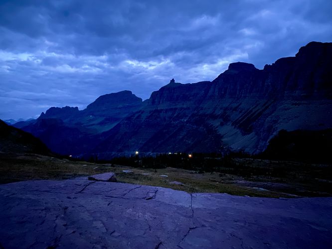
Hiking up Logan Pass

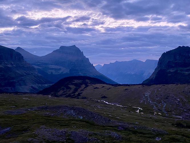
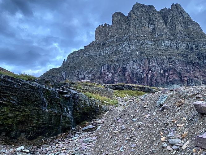
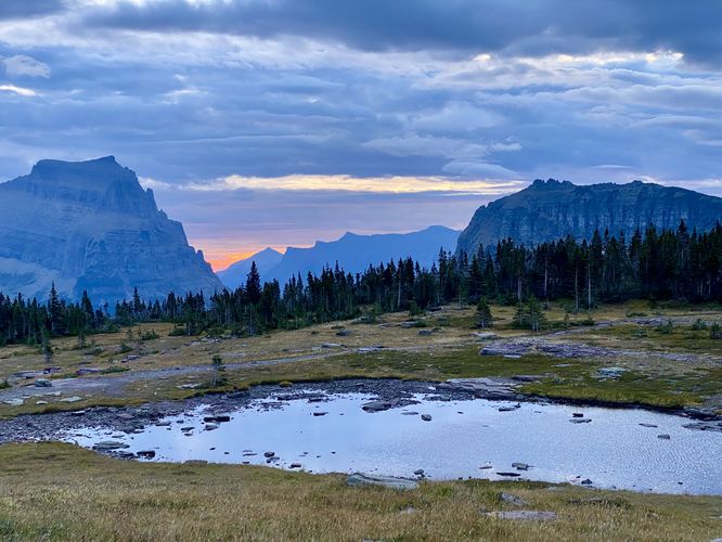
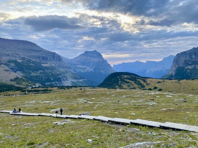
Along the way to Hidden Lake, you'll find rare alpine plants that grow as slow as half an inch in five years, which is why hikers should stay on the boardwalk at all times. Don't forget to turn around to find stunning views of the Going-to-the-Sun Road and the Garden Wall to the north along with the mountains to the east toward Saint Mary Lake. Heading up the pass toward Hidden Lake are views of Reynolds Mountain, located to the south and Clements Mountain to the north with its band of red rock and dotted snowfields. Around mile 0.9, hikers will find a ~10-foot tall waterfall that cascades off of a nearby cliff which is fed by melting snow from a snowfield on Clements Mountain.

Hidden Lake Pass - Mile 1.2

Hikers will reach the top of the main climb up from Logan Pass around mile 1, where the trail leads through an undulating spruce forest where you'll find a beautiful vernal pool located just off-trail near mile 1.2. Staying on-trail, however, you'll get beautiful eastward views of the alpine mountains toward Saint Mary Lake with the vernal pool in the foreground and spruce forest in between. During sunrise, this is a great spot to watch the colors change. To the west, the mountains near Hidden Lake start to present themselves like Bearhat Mountain sitting straight ahead, the flat-top like peak of Gunsight Mountain to its left, and Jackson Mountain to the south with its massive snowfields that sit on its northern slopes. The trail then runs mostly-flat to reach the overlook high above Hidden Lake.

Hidden Lake Overlook - Mile 1.38

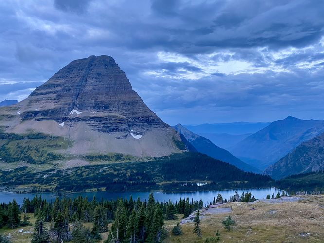
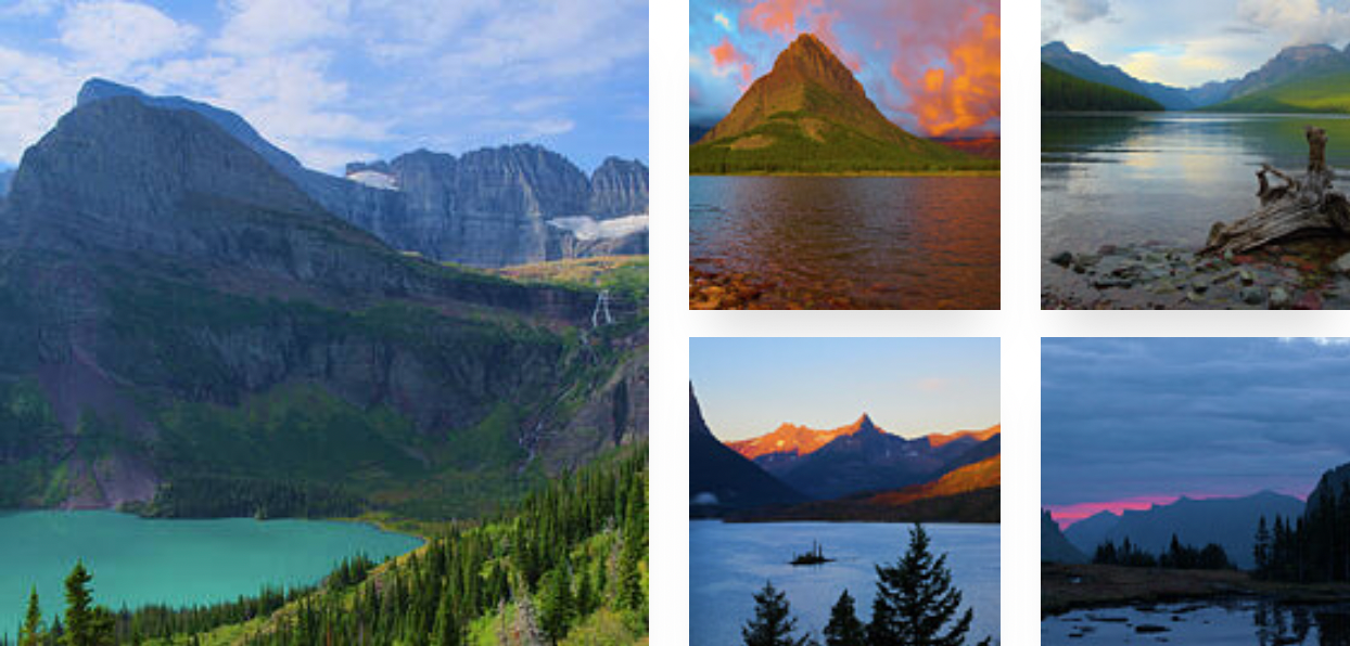
Hikers will reach the wooden platform of the Hidden Lake Overlook around mile 1.38, which sits just off of the main trail. From here, you'll find the deep turquoise-colored waters of Hidden Lake as it sits nestled within a stunning alpine landscape. Bearhat Mountain, the most noticeable mountain, sits straight ahead to the west with its towering ramparts of steep slopes and cliffs that stretch high above the water. Westerly views face a mountain pass that leads directly down to the Avalanche Lake valley. To the south, with its snow-capped slopes, hikers will find Mount Jackson. Gunsight Mountain is pretty easy to spot here too with its flat-top peak in between Mount Jackson and Bearhat Mountain.

Hiking Out - Mile 1.38 to 2.7

The hike back is straight forward, assuming you skip the difficult hike down to Hidden Lake itself. We skipped the hike down to Hidden Lake, assuming the views from the overlook were probably better, but to each their own. On our hike out, since we began before sunrise, we found the trail was littered with hikers -- dozens and dozens of hikers were headed up to Hidden Lake Overlook to start their day. We got lucky and had the trail to ourselves on the way up with only 2 hikers ahead of us. Despite the crowds that we encountered on the trail, the views of Logan Pass are often unmatched at the park. While hiking the boardwalk be sure to enjoy the rare plants, wildflowers, and potential wildlife like mountain goats or longhorn sheep grazing on the nearby cliffs on the way out.

Wildflowers

Logan Pass is one of the best places, aside from the Highline Trail, to view the abundant wildflowers that bloom at Glacier National Park. Note that Summer is the best season to show up to find wildflowers. During our trip in mid-to-late September, there were still some wildflowers, but the majority of them had already reached their peak.

Vehicle Reservations

Depending on what time of year you visit, you may need to reserve a vehicle entrance pass to get into the park, in addition to a park entry fee (or annual National Parks pass). Before planning this hike, ensure you've checked the NPS website for when and where Glacier NP vehicle reservations are required.

Parking

Visitors will find a large parking lot at the Logan Pass Visitor Center, located at the coordinates provided. The lot is large enough to fit many dozens of vehicles as of September 2024. Parking here, however, can be challenging depending on what time of year you arrive -- during vehicle reservation season, you may still find the parking lot is a challenge to park in but you may not need to arrive too early in the morning. After vehicle reservation season is over, this parking lot fills up extremely fast. During our visit here in mid-to-late September 2024, the parking lot was mostly-full by 6:45AM on a weekday. When the temperatures fell further, the parking lot was much quieter. Note that depending on when you arrive, you may need to wait around for a parking space to open up.

Pets

Dogs are not allowed on any trails at Glacier National Park.

Wildlife

This trail is great for possible wildlife viewing opportunities including mountain goats and longhorn sheep high in the cliffs. While most visitors are "almost guaranteed" to see mountain goat or longhorn sheep at Logan Pass, during our 1-week trip and driving by Logan Pass ~10 times, we only saw longhorn sheep.

Warning

Grizzly bears: This trail is frequented often by grizzly bears, especially in late Summer and early Fall as they scrounge for 20 hours/day bulking for the winter. Always give wild animals plenty of space, including several hundred feet for grizzlies. It's best to bring bear spray on this hike as a last defense just in case a grizzly were to charge at you. Always make plenty of noise while hiking to alert animals to your presence long before you see them. It's also smart to hike with another person.
Explore 43 trails near Saint Mary, MT
  1. Parking

    48.695763, -113.717544
  2. Main Trailhead

    48.695763, -113.717544
  3. View of the Garden Wall (glacial arete) and the Going-to-the-Sun Road from Logan Pass with vehicles ascending

    48.694089, -113.725281
    View of the Garden Wall (glacial arete) and the Going-to-the-Sun Road from Logan Pass with vehicles ascending
  4. Eastward view of mountains around Logan Pass

    48.690106, -113.732514
    Eastward view of mountains around Logan Pass
  5. ~10-foot tall waterfall

    48.689919, -113.732894
    ~10-foot tall waterfall
  6. Hidden Lake Overlook (Bearhat Mountain and Hidden Lake)

    48.687239, -113.741722
    Hidden Lake Overlook (Bearhat Mountain and Hidden Lake)
  7. View of mountains east of Logan Pass with vernal pool in the foreground

    48.687539, -113.738161
    View of mountains east of Logan Pass with vernal pool in the foreground
  8. View into Logan Pass with boardwalk of the trail

    48.692956, -113.728103
    View into Logan Pass with boardwalk of the trail
No community routes found. To add your own hike as a Community Route for this Trail guide, leave a Trip Report with an attached GPX file.

Seasons

Spring, Summer, Fall

Trip Reports

Trail Guide By:
Admin user profile picture
2.7 miles / 4.3 km
2.7 miles / 4.3 km
September 17, 2024
Started off on a cold morning before sunrise with only 2 hikers ahead of us and no one behind for quite a while. Had the trail to ourselves and watched the sunrise at Logan Pass. Views of Hidden Lake were worth the hike up.
Hiking

Weather Forecast

In Saint Mary, MT

Explore Hiking Trails

You May Also Like

Colorado's Million Dollar Highway - Plan a day's drive adventure along the iconic Million Dollar Highway in Colorado. Explore the best short trails, roadside stops, waterfalls, vistas, ghost towns, and hot springs within a ~6 hour road trip.
Explore

Colorado's Million Dollar Highway

Plan a day's drive adventure along the iconic Million Dollar Highway in Colorado. Explore the best short trails, roadside stops, waterfalls, vistas, ghost towns, and hot springs within a ~6 hour road trip.

Read
Glacier's Going-to-the-Sun Road - Discover the breathtaking beauty of Glacier National Park along the iconic Going-to-the-Sun Road. From stunning roadside stops to picturesque waterfalls and vistas, this engineering marvel offers endless opportunities for exploration.
Explore

Glacier's Going-to-the-Sun Road

Discover the breathtaking beauty of Glacier National Park along the iconic Going-to-the-Sun Road. From stunning roadside stops to picturesque waterfalls and vistas, this engineering marvel offers endless opportunities for exploration.

Read
New York's Best Waterfalls - Whether you're planning a day hike, roadside stop, or a leisurely short walk, this guide provides hikers, travelers, and locals alike with 63 different locations to over 100 scenic waterfalls to help plan your next adventure!
Explore

New York's Best Waterfalls

Whether you're planning a day hike, roadside stop, or a leisurely short walk, this guide provides hikers, travelers, and locals alike with 63 different locations to over 100 scenic waterfalls to help plan your next adventure!

Read

Before you boogie...

Find our trail guides useful? Consider becoming a Supporter to unlock perks!

MyHikes is an indie platform that makes exploring public trails easier for everyone. The platform has no investors, no ads, and is owned and operated by one person, Dave Miller. Dave has personally mapped and written over 1,800 trail guides on MyHikes for the public to explore. MyHikes has helped millions outdoor enthusiasts plan their next adventure.

But it takes a lot of time ๐Ÿ•ฆ, money ๐Ÿ’ฐ, work, and espresso shots โ˜• to run MyHikes, including hiking , mapping , writing , and publishing new trails with high-quality (accurate) information... along with software engineering (coding) the platform like building new features, website and mobile app development (iOS and Android), site maintainance . and much much more.

Supporters unlock website and mobile app perks with an annual one-time payment of $25 (you renew) ๐Ÿ˜Ž๐Ÿ‘. Or you can simply make a Donation of your choice. Otherwise, you can support us by telling your friends about MyHikes - both quick and free ๐ŸŽ‰

Admin user profile picture

Dave Miller
MyHikes Founder