The Avalanche Lake Trail at Glacier National Park near West Glacier, Montana is a moderate 3.9-mile out-and-back hike that leads to Avalanche Lake and its 2,000-foot tall waterfalls while passing through a cedar forest full of moss-covered rocks and a gorge with turquoise-colored cascades.
Cliffs/gorge: This trail passes a beautiful gorge within Avalanche Creek. There are several places with fences lining the gorge, but some views of the waterfalls and cascades within the gorge are not sitting behind fences, hence you must be extra careful near the edge of the gorge. One false step could send you into the gorge and could cause serious injury or drowning. Hike at your own risk.
Trails
In order to reach this trailhead, you must first hike-in along the Trail of the Cedars for 0.5-miles. The route provided follows the Avalanche Lake Trail. For more information on how to reach the trailhead, check out our guide on the Trail of the Cedars.Hiking to Avalanche Lake
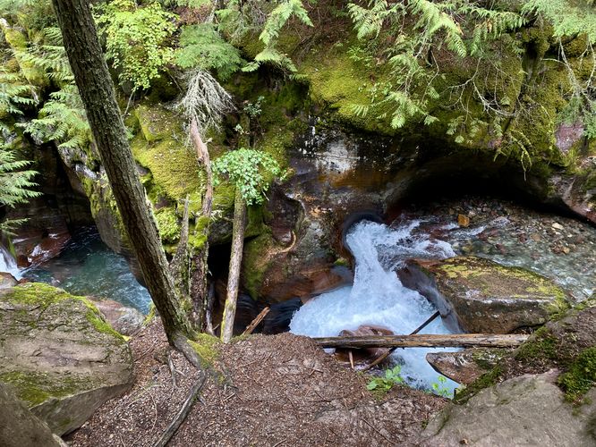
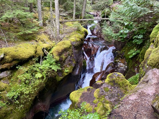
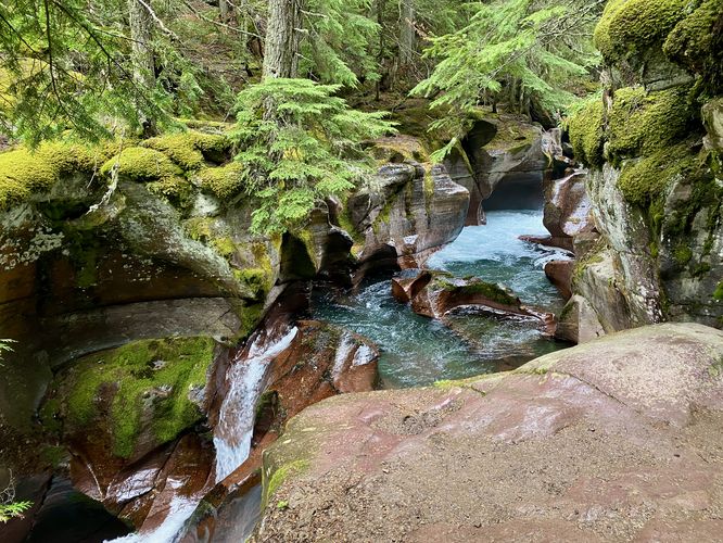
This trailhead begins at the southern-most point along the Trail of the Cedars, so hikers will want to plan on 1 extra mile of hiking that trail to explore Avalanche Lake. The best part of hiking both trails is the Trail of the Cedars provides hikers with an opportunity to explore an old growth western red cedar forest along with a beautiful turquoise section of Avalanche Creek as it flows through a moss-covered gorge.Avalanche Creek's Gorge and Cascades - Mile 0 to 0.1
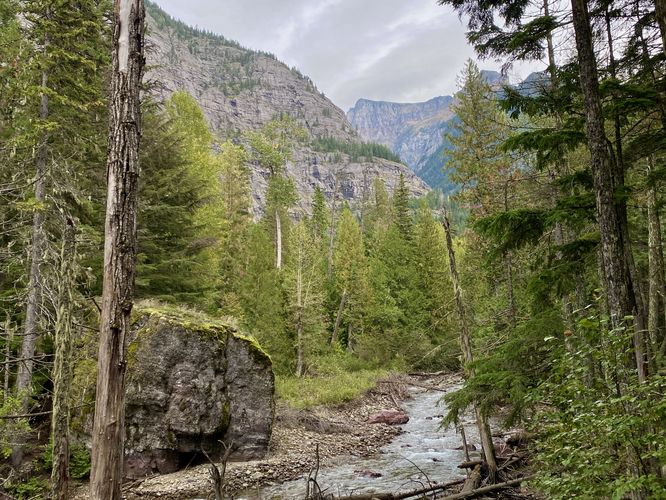
The Avalanche Lake Trail leads uphill from the trailhead and then curves to the east. Just beyond the initial curve in the trail is where the Avalanche Creek gorge sits with turquoise-colored cascades and pools sitting below. Hikers will find several overlooks into the gorge with at least three different sections of short waterfalls plunging through the bedrock. The gorge is covered in moss, some ferns, and is surrounded by western red cedar trees which makes it feel like it's ecosystem is straight out of the Pacific Northwest region. The clouds at the park generally become trapped on the west side around Avalanche Lake and thus create a similar ecosystem like the Pacific Northwest. The gorge provides hikers with a neat way to explore this unique ecosystem with its turquoise waters flowing down small waterfalls below. Watch your step though as some spots are a bit sketchy and sit along the gorge's ledges for the best views.Hiking the Trail - Mile 0.1 to 1.85
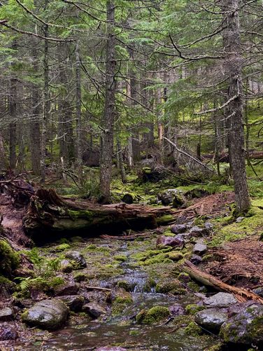
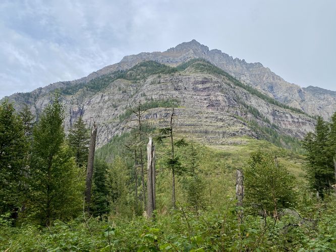
After passing the Avalanche Creek gorge near the trailhead, the Avalanche Lake Trail leads southeast through the lush forest as it makes its way toward Avalanche Lake. Along the way are scenic views of the creek, nearby alpine mountains, and lush forest full of moss. Some noteworthy stops along the way are a nice view of Avalanche Creek around mile 0.25, an alpine view around mile 1.15, and a shallow tributary creek with abundant moss around mile 1.3. There are several other nice views of the creek on the way up to Avalanche Lake, but the POI listed are the main stops. You'll find plenty of scenery among the moss-covered forest floor and tree trunks along the trail.Avalanche Lake - Mile 1.9 to 2
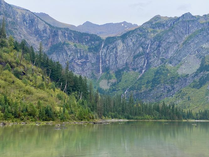
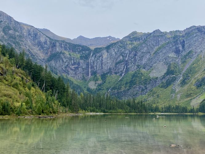
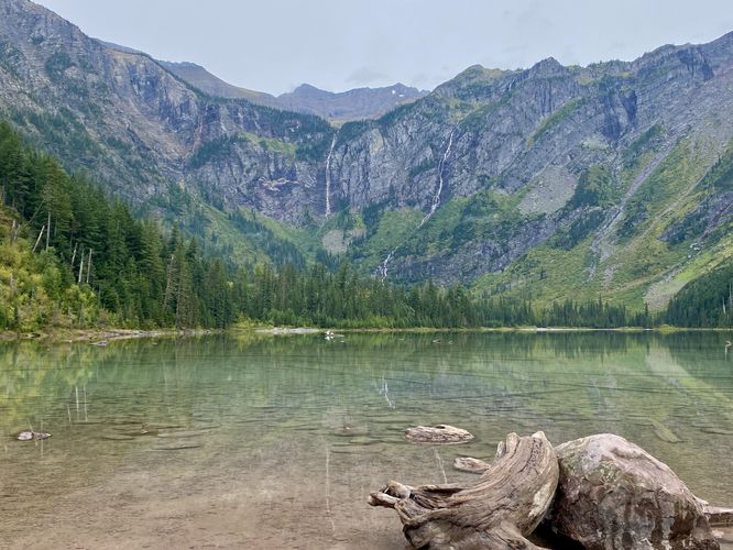
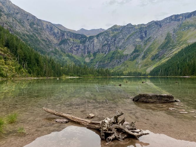
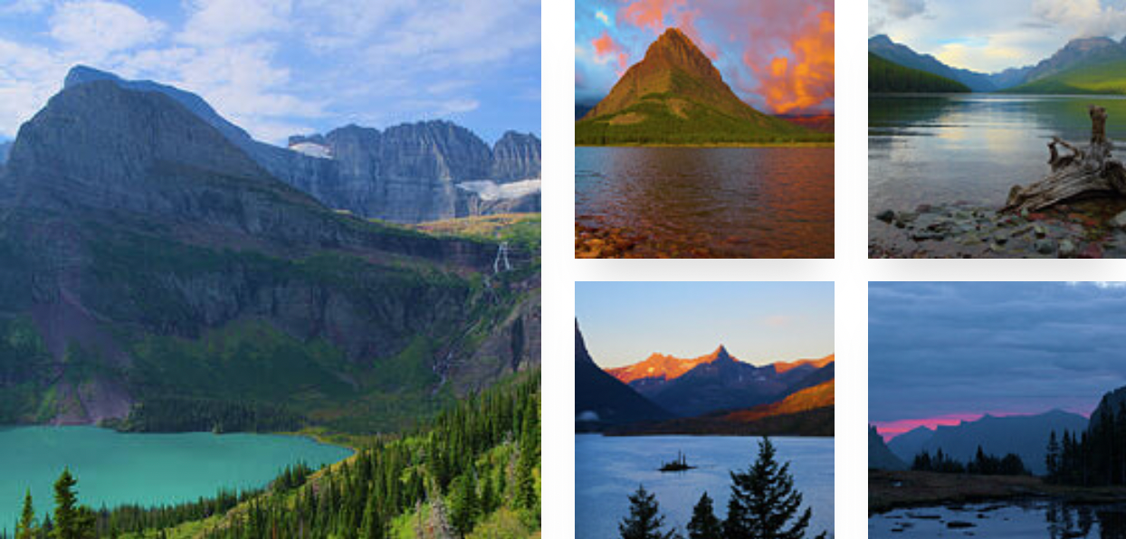
The trail will reach a fork around mile 1.88 where this route keeps-left at the junction. To be fair, we should have stayed on-trail to reach an easier offshoot trail that leads to the water's edge of Avalanche Lake. At mile 1.9, you'll reach the western-most view of Avalanche Lake where you'll find a pile-up of dead trees which get clogged near the outflow of Avalanche Creek from the lake. Here, you can either choose to hike over these dead trees to reach the true shore of Avalanche Lake or head back to the junction and around to reach the easier-to-access lake shore path. Either way you go, once you reach the shoreline of Avalanche Lake, around mile 1.9 to 2, you'll find the best views of the lake and its ~2,000-foot waterfalls that plunge down from Sperry Glacier to Avalanche Lake below. One of these massive waterfalls is known as Monument Falls, located on the left-hand side of the glacial cirque. Avalanche Lake's water has a green hue with shades of tan and brown in the foreground, created by the sandy-like lake bottom. Avalanche Lake is a bit different from the other alpine lakes at the park since it's lake bottom isn't full of colorful rocks but rather crushed rocks that turned into a sandy substrate. Despite the difference in water color, Avalanche Lake is still by far one of the most-scenic places in the park and albeit not difficult to access. The lake sits in a valley that was once carved by massive ancient glaciers that formed this glacial cirque. In the distance, at the far side of the lake, are at least three massive waterfalls that cascade down the mountains to reach the lake. The water that flows down these waterfalls melts directly from the Sperry Glacier which sits high up in the hanging valley overhead. The surrounding mountains within this glacial cirque are Little Matterhorn, Edwards Mountain, and Gunsight Mountain. After enjoying the lake and its breathtaking scenery, hikers will begin their downhill trek back to the Trail of the Cedars.Hiking back to the Trail of the Cedars - Mile 2 to 3.9
After exploring the scenery of Avalanche Lake, the hike back to the Trail of the Cedars is relatively easy. Most of the trail, with small exceptions, leads downhill as it follows the flow of Avalanche Creek. The hike back allows you to enjoy some of the views that you passed earlier -- whether its the alpine mountains, Avalanche Creek, or the stunning turquoise water gorge near the trailhead. If you hiked up in the late afternoon, you might find that the hike back to parking is a lot more quiet than earlier in the day, which is how we enjoyed this trail virtually "alone" as most hikers had left to grab dinner that day. The trail terminates along the southern end of the Trail of the Cedars which completes the 3.9-mile out-and-back hike along the Avalanche Lake Trail. At the loop you'll want to hike the opposite side you hiked-in on to head back to parking. By the time you reach the parking lot, you will have explored both the Avalanche Lake Trail and the entire Trail of the Cedars for an enjoyable 5-mile trek.Parking
Hikers will find several parking lots and turnout locations for this hike, located near the coordinates provided along the Going-to-the-Sun Road. The coordinates will bring you to the parking turnout spaces located on-road where you'll find a couple dozen parking spaces. Just before this turnout, located on the west side of the road is a smaller turnout area with about 1 dozen parking spaces. To the west of the southern turnout location is a larger parking lot complex that can hold a few dozen vehicles. Despite the excessive parking, hikers will find that these spaces fill up quickly each day and you might need to wait around for a parking space to open.Popularity
This is one of the most popular and crowded spots within Glacier National Park.Vehicle Reservations
Depending on what time of year you visit, you may need to reserve a vehicle entrance pass to get into the park, in addition to a park entry fee (or annual National Parks pass). Before planning this hike, ensure you've checked the NPS website for when and where Glacier NP vehicle reservations are required.Pets
Dogs are not allowed on any trails at Glacier National Park.Warning
Grizzly bears: This trail can be frequented by grizzly bears, especially in late Summer and early Fall as they scrounge for 20 hours/day bulking for the winter. Always give wild animals plenty of space, including several hundred feet for grizzlies. It's best to bring bear spray on this hike as a last defense just in case a grizzly were to charge at you. Always make plenty of noise while hiking to alert animals to your presence long before you see them. It's also smart to hike with another person.Cliffs/gorge: This trail passes a beautiful gorge within Avalanche Creek. There are several places with fences lining the gorge, but some views of the waterfalls and cascades within the gorge are not sitting behind fences, hence you must be extra careful near the edge of the gorge. One false step could send you into the gorge and could cause serious injury or drowning. Hike at your own risk.