The Herrington Trail at Tioga State Forest near Ansonia, Pennsylvania is a moderate 3.8-mile out-and-back trail that runs through Herrington Hollow, eventually terminating at private property before returning to parking, and features a couple of small scenic off-trail waterfalls.
Trails
This hike follows the Herrington Trail.
Blaze Colors
As of December 2021, this trail was marked with blue ribbons for blaze markers. Please note that the proper color for blazes on this trail is red to indicate a multi-purpose trail; however, it seems the private land owners who have access to the southern terminus of this trail maintain the path and have likely placed the blue ribbons. Thanks for maintaining!
Hike Description
This trail begins at the trailhead located at the dead end of Goodall Rd near where the old fire tower was located and near the old stone cabin. Note that as of December 2021, OpenStreetMap does not show the road on the map, but it's definitely there.
The trail begins at the top of the mountain and gradually makes its way over to where the mountain descent begins around 0.2-miles in. The trail becomes a bit more steep as it winds its way down into Herrington Hollow.
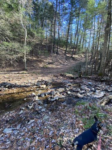
Creek Crossing #1 - Mile 0.95
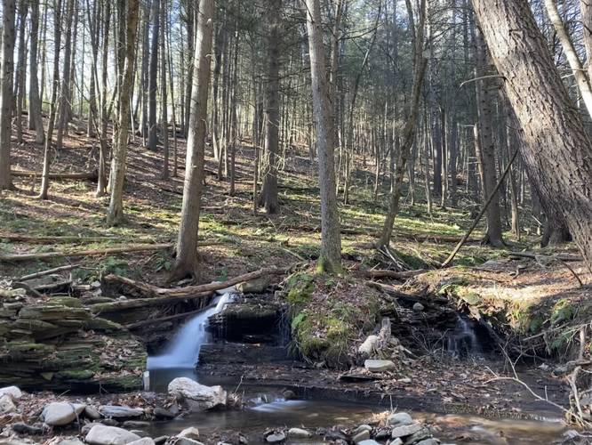
Around mile 0.95, hikers will find that the blue ribbons cross the creek. After the first creek crossing, the trail begins to follow an old grade that appears to be an old log slide left over from the former logging era. As you make your way down the mountain, Herrington Hollow's ravine becomes steeper and deeper - eventually reaching a depth of about 60-70 feet with very steep hillsides along the trail. The creek below has very small cascades of about 1-foot tall that spill down the creek, which makes for a scenic hike. Eventually the trail will head downhill into the ravine, at a moderate grade, to reach the second creek crossing.
Creek Crossing #2 - Mile 1.7
At mile 1.7, the trail crosses the creek one last time. This creek crossing is wider and a bit deeper (albeit no more than 1-foot deep during 'dry' seasons in certain areas). Right after the second creek crossing, the trail heads uphill slightly as it meanders into a evergreen grove. Just on the other side of this evergreen grove, after the trail has lead the hiker downhill a bit, will reach a metal gate and a barbed-wire fence. This is where the trail terminates and private property begins. The hike back starts here, but do not forget to checkout the two waterfalls nicknamed Herrington Hollow Falls on your way back up the mountain.
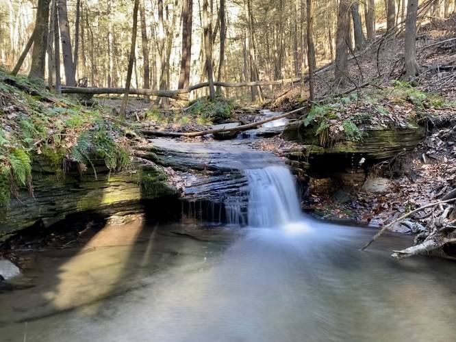
Herrington Hollow Falls - Upper and Lower Falls
Located just off-trail near the second creek crossing (near mile 1.8) of the Herrington Trail are two small, but scenic, waterfalls that cascade down the creek. The first waterfall, Upper Herrington Falls, cascades in two tiers into a small pool below - the first tier of the waterfall is no more than 1-foot tall with the second tier being about 3-feet tall. While it's a very small cascade, it made for a nice stop along this forested hike. Just downstream is Lower Herrington Falls, which is yet another short but scenic waterfall. Lower Herrington Falls is a split waterfall where the left-hand side cascades into a 4-foot deep "canyon" of bedrock while the right-hand side spills down a step-like rock face before both converge in the creek below. The left-hand side of Lower Herrington Falls is interesting because the water does not flow directly downstream, but rather hits a 90-degree wall of rock, before changing direction and flowing 90-degrees outward and back into the stream. I (Admin) have honestly never seen a waterfall like this before.
Hiking Back
The hike back to parking is not very difficult aside from the creek crossings and the steeper mountainside as the trail approaches the top of the mountain. Otherwise, the uphill climb along the moderate graded old log slide is a peaceful and scenic way to explore Herrington Hollow on this mountain.
Parking
Hikers will find a large parking turnout at the coordinates provided which sits at the end of Goodall Rd near Ansonia, PA within Tioga State Forest. Note that the OpenStreetMap map tiles, as of December 2021, do not show a road here for some reason but it does exist.
Seasonal Views
During the colder months when no leaves are on the trees, hikers will find a couple of spots that give very obstructed but interesting views of the surrounding area. At the top of the trail, hikers will get a view of the neighboring mountain ridge that helps define Herrington Hollow's geography. Near the bottom of the trail, within the evergreen grove, is a view of Mount Tom and the mountain that makes up the Bee Tree Hollow Trail's route - both mountains help define the true "start" to the PA Grand Canyon in the village Ansonia, Pennsylvania.
Pets
Dogs are allowed if leashed and their waste should be carried out by the hiker.
Hunting
Hunting is allowed here, so wearing blaze orange is a good idea during hunting seasons.
Camping and Backpacking
While there were no campsites along this trail, backpacking is permitted in this section of the state forest. Please follow all state forest rules when primitive / backcountry / dispersed camping along this trail.
Trails
This hike follows the Herrington Trail.
Blaze Colors
As of December 2021, this trail was marked with blue ribbons for blaze markers. Please note that the proper color for blazes on this trail is red to indicate a multi-purpose trail; however, it seems the private land owners who have access to the southern terminus of this trail maintain the path and have likely placed the blue ribbons. Thanks for maintaining!
Hike Description
This trail begins at the trailhead located at the dead end of Goodall Rd near where the old fire tower was located and near the old stone cabin. Note that as of December 2021, OpenStreetMap does not show the road on the map, but it's definitely there.
The trail begins at the top of the mountain and gradually makes its way over to where the mountain descent begins around 0.2-miles in. The trail becomes a bit more steep as it winds its way down into Herrington Hollow.
Creek Crossing #1 - Mile 0.95
Around mile 0.95, hikers will find that the blue ribbons cross the creek. After the first creek crossing, the trail begins to follow an old grade that appears to be an old log slide left over from the former logging era. As you make your way down the mountain, Herrington Hollow's ravine becomes steeper and deeper - eventually reaching a depth of about 60-70 feet with very steep hillsides along the trail. The creek below has very small cascades of about 1-foot tall that spill down the creek, which makes for a scenic hike. Eventually the trail will head downhill into the ravine, at a moderate grade, to reach the second creek crossing.
Creek Crossing #2 - Mile 1.7
At mile 1.7, the trail crosses the creek one last time. This creek crossing is wider and a bit deeper (albeit no more than 1-foot deep during 'dry' seasons in certain areas). Right after the second creek crossing, the trail heads uphill slightly as it meanders into a evergreen grove. Just on the other side of this evergreen grove, after the trail has lead the hiker downhill a bit, will reach a metal gate and a barbed-wire fence. This is where the trail terminates and private property begins. The hike back starts here, but do not forget to checkout the two waterfalls nicknamed Herrington Hollow Falls on your way back up the mountain.
Herrington Hollow Falls - Upper and Lower Falls
Located just off-trail near the second creek crossing (near mile 1.8) of the Herrington Trail are two small, but scenic, waterfalls that cascade down the creek. The first waterfall, Upper Herrington Falls, cascades in two tiers into a small pool below - the first tier of the waterfall is no more than 1-foot tall with the second tier being about 3-feet tall. While it's a very small cascade, it made for a nice stop along this forested hike. Just downstream is Lower Herrington Falls, which is yet another short but scenic waterfall. Lower Herrington Falls is a split waterfall where the left-hand side cascades into a 4-foot deep "canyon" of bedrock while the right-hand side spills down a step-like rock face before both converge in the creek below. The left-hand side of Lower Herrington Falls is interesting because the water does not flow directly downstream, but rather hits a 90-degree wall of rock, before changing direction and flowing 90-degrees outward and back into the stream. I (Admin) have honestly never seen a waterfall like this before.
Hiking Back
The hike back to parking is not very difficult aside from the creek crossings and the steeper mountainside as the trail approaches the top of the mountain. Otherwise, the uphill climb along the moderate graded old log slide is a peaceful and scenic way to explore Herrington Hollow on this mountain.
Parking
Hikers will find a large parking turnout at the coordinates provided which sits at the end of Goodall Rd near Ansonia, PA within Tioga State Forest. Note that the OpenStreetMap map tiles, as of December 2021, do not show a road here for some reason but it does exist.
Seasonal Views
During the colder months when no leaves are on the trees, hikers will find a couple of spots that give very obstructed but interesting views of the surrounding area. At the top of the trail, hikers will get a view of the neighboring mountain ridge that helps define Herrington Hollow's geography. Near the bottom of the trail, within the evergreen grove, is a view of Mount Tom and the mountain that makes up the Bee Tree Hollow Trail's route - both mountains help define the true "start" to the PA Grand Canyon in the village Ansonia, Pennsylvania.
Pets
Dogs are allowed if leashed and their waste should be carried out by the hiker.
Hunting
Hunting is allowed here, so wearing blaze orange is a good idea during hunting seasons.
Camping and Backpacking
While there were no campsites along this trail, backpacking is permitted in this section of the state forest. Please follow all state forest rules when primitive / backcountry / dispersed camping along this trail.