Loading...

๐Ÿ Fall is here! Check out our foliage map to plan your autumn hikes! Learn more.

Heart Lake Loop Trail

Directions
Map
Pictures
Send to App
Distance:
1.1 Miles / 1.8 km
Type:
Loop
Difficulty:
Easy
Time to Hike:
~33 minutes
Features:
Surface Type:
Dirt
Park:
Adirondack Park
Town:
North Elba, New York
Get Directions:
44.18307, -73.963799
Added:
March 05, 2022
Updated:
April 27, 2022
Copy Trail Link Hiking this trail? Send a friend or family member a link to this trail guide for your own safety. Hike at your own risk (disclaimer)
Loading...
Loading...
60'

Total Change
75'

Ascent
75'

Descent

Download the Trail Route for Offline Use

Supporters get exclusive access to download trail routes to the MyHikes app for offline use. Stay prepared on your adventure, even without an internet connection! Become a Supporter today to unlock this feature and hike with confidence.

Send to App

Key Takeaways

  • The Heart Lake Loop Trail is an easy 1.1-mile loop in Adirondack Park, offering views of mountains and the lake, with potential for snowshoeing in winter.
  • The trail starts at the ADK Loj and includes various points of interest like the Heart Lake beach, Mount Jo views (in winter), and connections to other trails like Indian Pass and Old Marcy Dam.
  • Parking is available at the High Peaks Wilderness lots (fees apply), and dogs are allowed on leash (waste must be carried out); paid lean-to camping is available nearby with reservations through the ADK.

Heart Lake Loop Trail

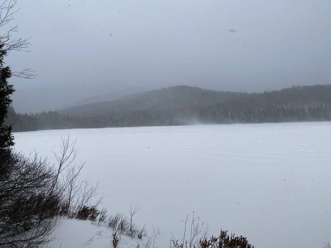
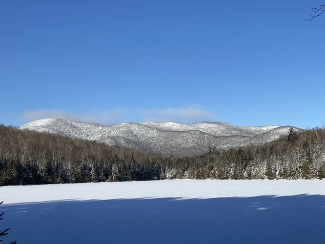
The Heart Lake Loop Trail at Adirondack Park near North Elba, New York is an easy 1.1-mile loop trail that encompasses Heart Lake and features views of some of the mountains within the High Peaks Wilderness like Wright Peak and Algonquin Peak. During the winter, this lake is usually frozen over, allowing hikers to snowshoe across - giving views of Mount Jo as well.

This GPS track begins at the ADK Loj and heads north along the purple blazes, passing the Mount Jo Trail, and Roger's Lookout as it meanders its way around the lake. From the start of the trail, hikers get a nice view from the Heart Lake beach of Nye Mountain and Street Mountain directly across the lake. This trail should be considered easy, but it does get a bit rocky in some areas. Eventually the trail will pass the Indian Pass Trail before circling Heart Lake to the south to reach the Old Marcy Dam Trail in the southeast corner. Last, the trail heads north to loop back to the ADK Loj where this trail ends.

Parking
Hikers will find parking at the coordinates provided at the main lots for the High Peaks Wilderness at the end of Adirondack Loj Road near North Elba, NY. The parking lots are large enough to fit many dozens of vehicles. There is a day-use and overnight parking fee for ~7/half-day, ~$15/full-day for non-members. Please check with the ADK for more information.

Pets
Dogs are allowed if leashed and their waste must be carried out by the hiker.

Camping
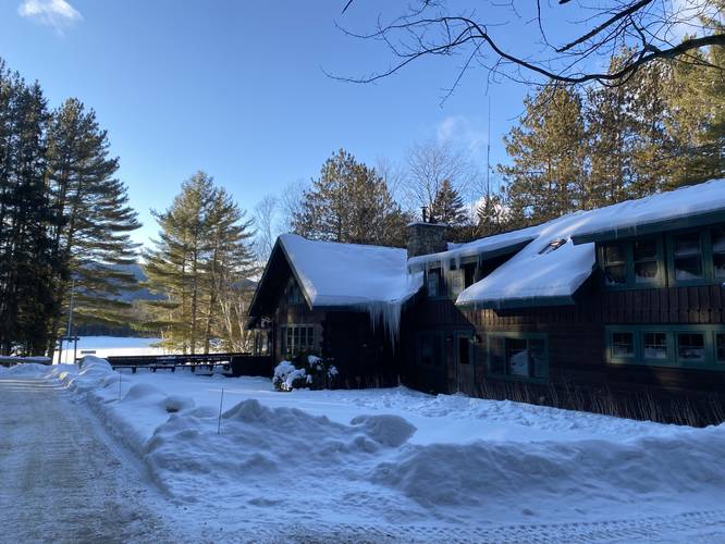
There are paid-for lean-to's located along Heart Lake, just off of this trail, that backpackers and campers can rent out from the ADK with reservations. Please check out the ADK website for more information.
Explore 35 trails near North Elba, NY
  1. Parking

    44.18307, -73.963799
  2. Main Trailhead

    44.182589, -73.966312
  3. Roger's Lookout along Heart Lake

    44.184078, -73.967347
    Roger's Lookout along Heart Lake
  4. View of Nye Mountain and Street Mountain from the Heart Lake beach

    44.182769, -73.966653
    View of Nye Mountain and Street Mountain from the Heart Lake beach
No community routes found. To add your own hike as a Community Route for this Trail guide, leave a Trip Report with an attached GPX file.

Hazards

Ticks - Lyme Disease More Info (CDC)

Seasons

All

Blaze Color

Purple

Photo Albums

+ Add Photo Album

Upload your photos from the trail to help others know what to expect.

Preview of the MyHikes mobile app interface

Track, Log, and Explore Hikes with the MyHikes App

Explore Autumn Foliage

No Change
Some Color
Low Color
Moderate Color
High Color
Peak Color
Past Peak
Sept 1 Sept 8 Sept 15 Sept 22 Sept 29 Oct 6 Oct 13 Oct 20 Oct 27 Nov 3 Nov 10 Nov 17 Nov 24

Trip Reports (Reviews)

Ready to help fellow hikers? Add a trip report to share your experience and provide valuable insights for those planning their next hike. Your review makes the trail better for everyone.

Your opinion matters! Be the first to rate this trail.
0.4 miles / 0.6 km
January 30, 2022
Snowshoed out to the middle of Heart Lake while it was totally frozen over at the end of January 2022 near sunset. Got some nice photos of Mount Jo and Nye Mountain.
Hiking Snowshoeing

Weather Forecast

In North Elba, NY

Explore Hiking Trails

You May Also Like

Colorado's Million Dollar Highway - Plan a day's drive adventure along the iconic Million Dollar Highway in Colorado. Explore the best short trails, roadside stops, waterfalls, vistas, ghost towns, and hot springs within a ~6 hour road trip.
Explore

Colorado's Million Dollar Highway

Plan a day's drive adventure along the iconic Million Dollar Highway in Colorado. Explore the best short trails, roadside stops, waterfalls, vistas, ghost towns, and hot springs within a ~6 hour road trip.

Read
Glacier's Going-to-the-Sun Road - Discover the breathtaking beauty of Glacier National Park along the iconic Going-to-the-Sun Road. From stunning roadside stops to picturesque waterfalls and vistas, this engineering marvel offers endless opportunities for exploration.
Explore

Glacier's Going-to-the-Sun Road

Discover the breathtaking beauty of Glacier National Park along the iconic Going-to-the-Sun Road. From stunning roadside stops to picturesque waterfalls and vistas, this engineering marvel offers endless opportunities for exploration.

Read
New York's Best Waterfalls - Whether you're planning a day hike, roadside stop, or a leisurely short walk, this guide provides hikers, travelers, and locals alike with 63 different locations to over 100 scenic waterfalls to help plan your next adventure!
Explore

New York's Best Waterfalls

Whether you're planning a day hike, roadside stop, or a leisurely short walk, this guide provides hikers, travelers, and locals alike with 63 different locations to over 100 scenic waterfalls to help plan your next adventure!

Read

Before you boogie...

Find our trail guides useful? Consider becoming a Supporter to unlock perks!

MyHikes is an indie platform that makes exploring public trails easier for everyone. The platform has no investors, no ads, and is owned and operated by one person, Dave Miller. Dave has personally mapped and written over 1,800 trail guides on MyHikes for the public to explore. MyHikes has helped millions outdoor enthusiasts plan their next adventure.

But it takes a lot of time ๐Ÿ•ฆ, money ๐Ÿ’ฐ, work, and espresso shots โ˜• to run MyHikes, including hiking , mapping , writing , and publishing new trails with high-quality (accurate) information... along with software engineering (coding) the platform like building new features, website and mobile app development (iOS and Android), site maintainance . and much much more.

Supporters unlock website and mobile app perks with an annual one-time payment of $25 (you renew) ๐Ÿ˜Ž๐Ÿ‘. Or you can simply make a Donation of your choice. Otherwise, you can support us by telling your friends about MyHikes - both quick and free ๐ŸŽ‰

Admin user profile picture

Dave Miller
MyHikes Founder