Loading...

❄️ WINTER SALE! 50% OFF on Supporter Accounts — now through January 31st. Unlock a full year of exclusive website & app perks. Learn More.

Hawksbill Mountain and Timber Hollow Hike

This teardrop hike from Timber Hollow Overlook on Skyline Drive passes around and over Hawksbill Mountain. Timber Hollow Overlook has a beautiful view of the Massanutten Range before the hike navigates the Appalachian Trail to the picturesque Salamander Trail. The summit of Hawksbill Mountain is one of the prettiest in the Shenandoah National Park, with 270 degree views From Kennedy Peak to Old Rag Mountain. This hike is also the sister to the Hawksbill Mountain/Franklin Cliffs circuit that reverses the teardrop section from the south.

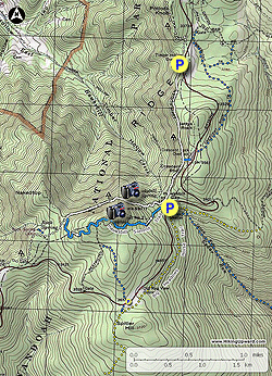
If you're short on time and still want to bag the 4,050ft Hawksbill summit, start the hike from the Hawksbill Gap parking area on Skyline Drive following the Lower Hawksbill Trail for a out and back 1.6 miles.

  • Mile 0.0 - From the parking area at Timber Hollow Overlook enjoy one of the best views of the hike. To the west is the Massanutten Range with New Market Gap and Strickler Knob visible to the northwest. Pass through the gap in the overlook wall and follow the connector trail down to the Appalachian Trail in 60 yards. Turn left on the Appalachian Trail (A.T.) south and pass around the western flank of Bettys Rock before arriving at the trail junction of the connecter trail to the Crescent Rock Overlook.

  • Mile 0.92 - Continue south on the A.T. for another 0.42 miles and arrive at the Hawksbill Gap parking connector trail.

  • Mile 1.34 - Stay straight remaining on the A.T. where the trail now begins to climb around the northern side of Hawksbill Mountain. Pass through a rock slide with views to the north. The A.T. becomes less steep after the rock slide area.

  • Mile 2.46 - Stay left onto the blue blazed Salamander Trail and begin the climb of Hawksbill Mountain. The trail will make four switchbacks before passing a spectacular view to the west of the Massanutten Range. Pass two more nice viewpoints and then the trail ends at the Birds Nest 2 Road.

  • Mile 3.23 - Turn left uphill on the Birds Nest 2 Road and pass the Birds Nest 2 shelter (day use only before arriving at the lookout at the summit of Hawksbill Mountain.

  • Mile 3.36 - At the summit there are expansive 270° views to the west, north and east, with a vista of Old Rag Mountain to the northeast. Return past the Birds Nest 2 shelter then take the Birds Nest 2 Road for 50 yards to the first trail intersection.

  • Mile 3.44 - Turn left downhill at with the blue blazed Lower Hawksbill Trail. The trail becomes increasingly steep, then levels out just before the intersection of the connector trail and Hawksbill Gap parking area at Skyline Drive.

  • Mile 4.13 - Turn left on the connector trail back into the woods arriving back at the A.T. in 100 yards.

  • Mile 4.16 - Turn right/north on the A.T. for 1.34 miles.

  • Mile 5.3 - Arrive back at Timber Hollow Overlook and parking area.

Explore 100 trails near Luray, VA

Know Before You Go

  • The 5.3-mile Hawksbill Mountain and Timber Hollow hike in Luray, VA, offers panoramic views, including the Massanutten Range and 270° vista from Hawksbill summit.
  • The hike combines sections of the Appalachian Trail and Salamander Trail, with options for shorter routes to the Hawksbill summit from the Hawksbill Gap parking area.
  • The teardrop loop starts at Timber Hollow Overlook, descends to the AT, ascends Hawksbill Mountain via the Salamander Trail, reaches the summit, descends via Lower Hawksbill Trail, and returns to the Overlook via the AT.
Interactive topographic map for Hawksbill Mountain and Timber Hollow Hike located in Luray, VA. Click the "View Map" button to load GPS coordinates and trail markers.
Get directions
Distance
5.3 mi
Difficulty
Moderate
Type
Out-and-Back
Est. Time
2.7 hrs
Elev. Gain
1,215'
Rating
3.8
Added
March 18, 2025
Updated
April 05, 2025

Weather Forecast

Tonight
Low 39°F
Mostly Cloudy
Wednesday
High 51°F
Chance Light Rain
Wednesday Night
Low 20°F
Chance Rain And Snow
Thursday
High 29°F
Sunny
Thursday Night
Low 15°F
Mostly Clear
Friday
High 34°F
Mostly Sunny
Friday Night
Low 25°F
Partly Cloudy
Saturday
High 41°F
Slight Chance Light Snow
Saturday Night
Low 19°F
Slight Chance Rain And Snow then Partly Cloudy
Sunday
High 28°F
Slight Chance Light Snow
Sunday Night
Low 15°F
Mostly Clear
M.L. King Jr. Day
High 34°F
Mostly Sunny
Monday Night
Low 14°F
Partly Cloudy
Tuesday
High 28°F
Sunny
Loading...
Total Change
714'
Ascent
1,215'
Descent
1,215'
Loading...

Download the GPX Data for Offline Use

Supporters get exclusive access to download trail routes to the MyHikes app for offline use. Stay prepared on your adventure, even without an internet connection! Become a Supporter today to unlock this feature and hike with confidence.

Download Hawksbill Mountain and Timber Hollow Hike GPX Data to the MyHikes Mobile App

Features

Vista / Lookout Point
Dogs
Mountain Summit
Appalachian Trail logo Appalachian Trail hike

Points of interest

  1. Parking

    38.574798, -78.384044
  2. Main Trailhead

    38.574798, -78.384044

Safety information

For your own safety: plan ahead, let someone know where you'll be, and hike at your own risk.

Hazards

Snakes (Rattlesnakes, Copperheads, others)
Poison Ivy or Poison Oak

Availability

All seasons

Surface type

Dirt

Trip Reports (Reviews)

Rated 3.8 out of 5 based on 5 ratings.

Ready to help fellow hikers? Add a trip report to share your experience and provide valuable insights for other hikers!

By: Diego
5.3 miles / 8.5 km
September 06, 2019
Did a shortened version starting from Hawksbill Gap parking lot. Trail conditions on the AT, Salamander, and Lower Hawksbill were excellent. On the Salamander trail, there are a few nice vistas (not marked on the trail map) before you get to the intersection with Lower Hawksbill. Views at the Hawksbill summit were top 10 in the state. Did get stung by a bee on the Salamander Trail, and I was minding my own business, so be careful.
Legacy Review
By: Scoutdadx3
5.3 miles / 8.5 km
June 23, 2019
We hiked this trail yesterday and it was awesome. We talked to several through-hikers along the way to Hawksbill Peak. At the top, there was a crowd of folks at overlook (probably a family) who basically camped out there. No one else could take photos or see the panorama. Additionally, one of the kids had a huge stick and was beating it on the wall. Rather than risk getting hit, we left as did others. What a shame to hike several miles to see the 270 degree vistas only to have disrespectful people ruin it. On another note, our gps tracked this hike closer to 7.5 miles, not the 5.5 as described above (and we did not do any side trails). We hiked from the parking lot at Timber Hollow up to the blue trail on the south side of Hawksbill Peak and then to the top. After that, we followed the directions and descended to the "Lower Hawksbill Parking Lot" where we connected back to the AT and traveled north back to the parking lot. Great day for a hike. The temperature at the parking lot was 65 degrees!
Legacy Review
By: Eric W
5.3 miles / 8.5 km
July 07, 2018
Very nice hike! Nobody was going our same way on the AT portion and as other commenters have said, the back way this hike takes you to the summit via the Salamander Trail seemed to be a much easier hike than the trail from the parking lot at Hawksbill. Along the way we had little springs and boulder piles you could explore, and you can't beat the views towards the summit. Overall did it in about 2 hours 45 minutes and enjoyed it without huge crowds.
Legacy Review
No community routes found. To add your own hike as a Community Route for this Trail guide, leave a Trip Report with an attached GPX file.

Popular categories

Scenic mountain view representing vista trails
Vista trails
Scenic gorge of cascades representing waterfall trails
Waterfall hikes
Rugged mountain terrain representing summit trails
Summit trails
Scenic mountain view representing dog-friendly trails
Dog-friendly
Scenic campsite with a view representing camping trails
Camping trails
Appalachian Trail logo representing A.T. hikes
A.T. hikes

You May Also Like

25 Best Day Hikes in North Carolina - Discover the top 25 best day hikes in North Carolina, from breathtaking waterfalls to mountain peaks. Explore hidden gems, scenic views, and trails suitable for all skill levels, perfect for your next outdoor adventure.
Explore

25 Best Day Hikes in North Carolina

Discover the top 25 best day hikes in North Carolina, from breathtaking waterfalls to mountain peaks. Explore hidden gems, scenic views, and trails suitable for all skill levels, perfect for your next outdoor adventure.

Read
🍪 We use cookies to learn about site usage and to serve map tiles. You may block cookies manually in the browser. By continuing you agree. Learn more