Loading...

🔥 End of Summer sale! 50% off on Supporter Accounts — now through September 1st. Learn More.

Hawksbill Franklin Cliffs Hike

Directions
Map
Pictures
Send to App
Distance:
8.4 Miles / 13.5 km
Type:
Loop
Difficulty:
Hard
Time to Hike:
4 hours, ~12 minutes
Features:
Appalachian Trail hike
Surface Type:
Dirt
Park:
Shenandoah National Park
Town:
Oldrag, Virginia
Directions:
38.555621, -78.386549
Added:
March 18, 2025
Updated:
April 05, 2025
Guide by:
Copy Trail Link Hiking this trail? Send a friend or family member a link to this trail guide for your own safety. Hike at your own risk (disclaimer)
Loading...
Loading...
1,197'

Total Change
1,847'

Ascent
1,849'

Descent

Download the Trail Route for Offline Use

Supporters get exclusive access to download trail routes to the MyHikes app for offline use. Stay prepared on your adventure, even without an internet connection! Become a Supporter today to unlock this feature and hike with confidence.

Send to App

Key Takeaways

  • The Hawksbill Franklin Cliffs Hike is an 8.4-mile loop in Old Rag, VA, offering diverse terrain with forest walks and panoramic vistas.
  • The hike combines segments on the Big Meadows Horse Trail, fire roads, the Appalachian Trail, and the Hawksbill Summit Trail, passing streams and offering views from Franklin Cliffs and Hawksbill Summit.
  • Key landmarks include the Old Rag overlook, Rose River feeder streams, Franklin Cliffs vistas overlooking the Massanutten range, and the 270-degree panorama from Hawksbill Summit including Old Rag.

Hawksbill Franklin Cliffs Hike

The first half of this circuit is a forest walk that passes 2 feeder streams for Rose River, and the second is vista after vista from both the Appalachian Trail and Hawksbill Summit. The views from Franklin Cliffs look out on the Massanutten range to the west, and there is a spectacular 270 degree panorama from the Hawksbill Summit with a view of Old Rag.

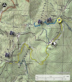
From the parking area start down the Cedar Run Trail for 50 yards to the intersection of the Big Meadows Horse Trail. Turn right on the yellow blazed Big Meadows Horse Trail and in 1.0 miles pass under the Old Rag overlook on Skyline Drive, then in 0.1 miles there is a campsite on the left. 0.2 miles after the campsite the trail will meet the intersection of a blue blazed connector trail that leads to parking on Skyline Drive.

Stay left on the yellow blazed Big Meadows Trail as it now heads downhill before turning back to the right and crossing the first of two streams in 1.7 miles. In another 0.4 miles cross the second and final stream. The Big Meadows Trail now continues for 0.7 miles to the intersection of the blue blazed Rose River Loop Trail. Turn right uphill remaining on the yellow blazed Big Meadows Trail for 0.5 miles to the intersection of a fire road.

Turn right on the fire road passing a chain gate and crossing Skyline Drive. Continue down the fire road for 100 yards to the intersection of the white blazed Appalachian Trail (A.T.).

Turn right on the A.T. and in 0.1 miles reach the first of several spectacular westerly vistas. Pass underneath Franklin Cliffs, then in 1.4 miles there is a side trail to a Skyline Drive parking area. From this point it's 1.0 miles to the Hawksbill Summit blue blazed trail.

Turn right on the blue blazed Hawksbill Mountain Summit Trail for 0.6 miles to a westerly vista. Shortly thereafter the trail turns left on a fire road on its way to the summit. Pass the shelter then in 50 yards reach Hawksbill Summit where there is 270 degree vista.

From the summit go back past the shelter for 25 yards, and turn left downhill on the continuation of the Hawksbill Summit Trail for the remaining 0.8 miles back to the Hawksbill Gap parking area.

Explore 88 trails near Oldrag, VA
  1. Parking

    38.555621, -78.386549
  2. Main Trailhead

    38.555621, -78.386549
No community routes found. To add your own hike as a Community Route for this Trail guide, leave a Trip Report with an attached GPX file.

Hazards

Ticks - Lyme Disease More Info (CDC)
Snakes
Poison Ivy/Oak

Seasons

All

Photo Albums

+ Add Photo Album

Upload your photos from the trail to help others know what to expect.

Trip Reports (Reviews)

Rated 3.86 out of 5 based on 35 ratings.
By: John
8.4 miles / 13.5 km
October 15, 2019
I checked out the hike for the foliage in mid October in 2019. It was still in the very early stages with some a little red here and there, but mostly green with a hit of yellow coming in. I enjoyed the Franklin Cliff section of the AT, though Hawksbill Mountain might had the better view. It was very busy on a weekday afternoon at Hawksbill summit. The Big Meadows Horse Trail was just a connector and a boring one at that in the green tunnels of VA. If solitude is what you are looking for, then you'll have it. The creeks were also dry since it has a been a dry month proceeding my hike. See my detailed report at: https://travel2walk.com/2019/10/16/virginia-hikes-franklin-cliffs-hawksbill-mountain-loop-october-15-2019/
Legacy Review
By: Nathan Cross
8.4 miles / 13.5 km
November 23, 2018
My wife and I did The Hawksbill Franklin Cliffs Hike yesterday. A very enjoyable hike! The route is great, and the vista from Hawksbill is astonishing. We did have an issue with ice on the trail, particularly on the last mile as you descend from the Hawksbill summit down to the parking area. The grade is slightly steep at times, and the trail was covered in super slippery ice. It was a bit tedious and made for very slow going, but overall it was an excellent hike and highly recommended. Thanks hiking upward!
Legacy Review
By: Jamey
8.4 miles / 13.5 km
March 26, 2018
This was a fantastic hike in several inches of snow, and it would be even better when the woods are green. I started at the Upper Hawksbill parking area. The woods along Big Meadow are pretty and the beginning stretch on the AT, with the views, cliffs, and mountain laurel, is beautiful. There was one set of boot prints for the first mile or so on Big Meadow, I broke trail to the junction with Rose River, and there were two sets of boot prints on the AT. This was a good workout with all the ups and downs. The snow made it a lot tougher than it normally would be, so I was glad I cut off a mile or so from this site's route. This was a great hike! Ignore the negative comments in some reviews (no, they're not the greatest vistas in SNP, but they're still amazing if you don't like rocks, take a stroll in a city park if you don't want to hear a few cars, don't choose a hike that's near Skyline Drive). The only people I saw were a guy who walked down from Skyline Drive to see the Rock Spring hut (which he somehow missed, despite the cement post and obvious path) and about 10 parking lot tourists at the summit.
Legacy Review

Weather Forecast

In Oldrag, VA

Explore Hiking Trails

You May Also Like

New York's Best Waterfalls - Whether you're planning a day hike, roadside stop, or a leisurely short walk, this guide provides hikers, travelers, and locals alike with 63 different locations to over 100 scenic waterfalls to help plan your next adventure!
Explore

New York's Best Waterfalls

Whether you're planning a day hike, roadside stop, or a leisurely short walk, this guide provides hikers, travelers, and locals alike with 63 different locations to over 100 scenic waterfalls to help plan your next adventure!

Read
25 Best Day Hikes in North Carolina - Discover the top 25 best day hikes in North Carolina, from breathtaking waterfalls to mountain peaks. Explore hidden gems, scenic views, and trails suitable for all skill levels, perfect for your next outdoor adventure.
Explore

25 Best Day Hikes in North Carolina

Discover the top 25 best day hikes in North Carolina, from breathtaking waterfalls to mountain peaks. Explore hidden gems, scenic views, and trails suitable for all skill levels, perfect for your next outdoor adventure.

Read

Before you boogie...

Find our trail guides useful? Consider becoming a Supporter to unlock perks!

MyHikes is an indie platform that makes exploring public trails easier for everyone. The platform has no investors, no ads, and is owned and operated by one person, Dave Miller. Dave has personally mapped and written over 1,800 trail guides on MyHikes for the public to explore. MyHikes has helped millions outdoor enthusiasts plan their next adventure.

But it takes a lot of time 🕦, money 💰, work, and espresso shots ☕ to run MyHikes, including hiking , mapping , writing , and publishing new trails with high-quality (accurate) information... along with software engineering (coding) the platform like building new features, website and mobile app development (iOS and Android), site maintainance . and much much more.

Supporters unlock website and mobile app perks with an annual one-time payment of $25 (you renew) 😎👍. Or you can simply make a Donation of your choice. Otherwise, you can support us by telling your friends about MyHikes - both quick and free 🎉

Admin user profile picture

Dave Miller
MyHikes Founder