This lollipop hike in the Harper Creek Wilderness Study Area of Pisgah National Forest is a premier day hike or weekend backpacking trip with two wonderful waterfalls and plenty of great campsites. Harper Creek is a major tributary of Wilson Creek, which is protected as a National Wild and Scenic River. This region, within the Grandfather Ranger District, is full of big waterfalls and large creeks that originate from the slopes of Grandfather Mountain and surrounding peaks. The wilderness study area is one of two in this area, and although the first section of this hike is popular, the western portion of the loop feels like true wilderness. Your first stop is Harper Creek Falls, which boasts two incredible swimming holes amid an impressive setting. Many day hikers stop here and take full advantage of the swimming and cliff jumping opportunities. This hike continues following Harper Creek west, crossing the creek many times making navigation surprisingly difficult at times. South Harper Creek Falls is a 120-foot marvel surrounded by smooth cliff walls over 200 feet high. You can explore this waterfall from the base, the middle, and a cliff view across the gorge, but one false move could be fatal. The return along the Raider Camp Trail lacks excitement, but you’ll stay out of the creeks long enough for your shoes to dry out before one last crossing of Harper Creek. This loop may be enough for one weekend, but there are many other waterfalls in the area if you wish to explore further.
Camping – There are many dispersed campsites throughout the Harper Creek Wilderness Study Area. The best are the series of massive flat sites during the first mile of the hike, but these are close to the road and may be crowded. You’ll find many smaller campsites beside the creek further into the region.
Navigation - As you hike along the Harper Creek Trail beyond Harper Creek Falls, the blazes become infrequent or non-existent, and many creek crossings are not marked. As a general rule of thumb the Harper Creek Trail stays very close to the creek, only rising high and away from the creek at the two waterfalls. You’ll cross Harper Creek and side streams 14 times on this hike, 12 of them are likely wet fords.
Waterfall Safety – The Harper Creek Trail does not provide access to the base of either waterfall. For most hikers, the views from the trail will be sufficient as described below. You’ll come across scramble trails and climbing ropes that afford access to daring hikers, but none of these are maintained by the forest service. It is up to you whether you want to try any of these scrambles.
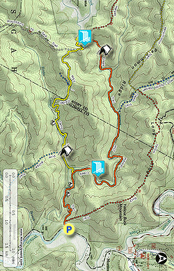
- Mile 0.0 – Beginning at the parking area on SR 1328/Brown Mountain Beach Rd, follow the Harper Creek Trail [260] (orange blaze) west.
- Mile 0.2 – At the top of the ridge pass by a T-junction with the Yellow Buck Trail [265] (red blaze) on the right and a fire ring on the left.
- Mile 0.8 – Below the trail on the left begins a long stretch of excellent campsites in a floodplain beside Harper Creek.
- Mile 0.9 – The trail dips down into the campsites, multiple trails fork left away from the main trail.
- Mile 1.2 – The Mountains-to-Sea Trail [440] (white blaze) and Raider Camp Trail [277] (yellow blaze) joins from the left between campsites. This is your return point from the loop. You are now following the MST and Harper Creek Trail north.
- Mile 1.4 – At a Y-junction the MST/Harper Creek Trail turns right while the obvious forest road grade continues straight. Stay straight on the road grade towards Harper Creek Falls.
- Mile 1.5 – A scramble trail on the left leads down to the base of Harper Creek Falls while the main trail ends at an overlook of the upper drops. There is no official trail to the base of this waterfall. The scramble to the base is steep and involves an open rock face at the bottom. There is a climbing rope anchored to the tree which you can use, but there is no guarantee this rope is in good condition. Otherwise you’ll have to improvise getting down to the base through dense vegetation or backtracking and creek-walking upstream. Once at the base you’ll see the spectacular Harper Creek Falls, a triple-drop waterfall enclosed by exposed cliffs. The lowest drop is a short slide, while the upper two drops are tucked between the cliffs at an angle. The pool at the base is massive and a popular swimming hole. Back on the trail continue straight to the overlook which shows a completely different perspective of the waterfall. The upper two drops plunge into a beautiful pool above the lowest drop. There is a way to get down to the pool above the lowest drop, but you are on your own here. It is hazardous and not for the faint-of-heart. There is no trail, only a steep rock face and a massive rope. Again, there is no guarantee this rope is in good condition. You’ll have to downclimb over 30 feet on wet rock and do the same thing back up. In the summer there might be many people trying this, but other times of the year you’ll be on your own with no one to help if you slip. If you get down you’ll get another perspective of the main drop into an enclave of eroded cliffs, and access to the beautiful, secluded pool.
- Mile 2.2 – Back on the MST/Harper Creek Trail continue north passing high above the waterfall.
- Mile 2.4 - After you pass the waterfall there are some campsites to the left beside the creek.
- Mile 3.1 – First wet crossing of Harper Creek. There is a small campsite on the other side along with an old railroad track. You’ll notice remnants of railroad and logging activity throughout this area, most of the trails were built along old railroad grades.
- Mile 3.4 – Second wet crossing of Harper Creek. The creek is very wide and beautiful here, and it is impossible to avoid getting wet. The trail now closely follows the creek providing many beautiful scenes upstream.
- Mile 4.3 – Y-junction with the North Harper Creek Trail [266] (blue blaze) on the right. The MST turns right following the North Harper Creek Trail. The less obvious Harper Creek Trail turns left and immediately crosses Harper Creek (wet #3) onto an island, then crosses the creek again. Upstream is the confluence of Harper Creek and North Harper Creek. The next 1.5 miles is the most isolated section of the hike. The trail is overgrown in many spots. You’ll have to navigate 9 creek crossings, almost all wet. Many of these crossings are not marked well. Although only designated as a wilderness study area, this feels like true wilderness.
- Mile 4.5 – Wet crossing #4 of Harper Creek.
- Mile 4.6 – Wet crossing #5 of Harper Creek.
- Mile 4.7 – Wet crossing #6 of Harper Creek.
- Mile 4.9 – Campsites on the right side of the trail.
- Mile 5.0 – Wet crossing #7 of a tributary of Harper Creek.
- Mile 5.1 – Wet crossing #8 of Harper Creek.
- Mile 5.2 – Probable wet crossing #9 of Harper Creek onto an island between the creek split. You’ll cross the creek again (wet #10) in a few hundred feet leaving the island.
- Mile 5.3 – Wet crossing #11 of Harper Creek.
- Mile 5.5 – The trail passes through sandy campsites beside the creek.
- Mile 5.7 – Wet crossing #12 of Harper Creek.
- Mile 5.8 – You’ll see the massive cliff walls around South Harper Creek Falls ahead. There is no official trail to the base of the waterfall. Before the trail starts climbing high, a steep scramble trail leads to the creek and an obvious fire ring is on the other side. If you can negotiate down the bank and across the creek, it is fairly easy to get close to the base of the waterfall. You can only see the lower slide from here. Getting to the base is more difficult, and you won’t see much more because of the slope of the waterfall. Continue on the trail as it switchbacks towards the top of the waterfall. The trail here is heavily eroded with many blowdowns that are treacherous.
- Mile 6.1 – Two trails branch off to the left of the main trail, which turns right. Take the second/upper more obvious trail on the left which takes you to the midpoint of South Harper Creek Falls. This looks like a dangerous area, but if you are not foolish and wander near the edge, you’ll be fine. (If the water level is high then the bedrock may be covered and this would be unsafe.) You are standing on bedrock in the middle of 120-foot South Harper Creek Falls. The 30-foot upper slide is directly above. After the brief flat section the water then slides over 90 feet to the bottom. Across the gorge cliffs soar high above the waterfall, an area which you’ll hike to next. Retrace your steps back to the main trail and continue climbing.
- Mile 6.35 – Pass by the top of the waterfall, which is a much more dangerous area and should not be explored.
- Mile 6.4 – Y-junction with the Raider Camp Trail [277] (yellow blaze) on the left. Turn left and ford Harper Creek (#13). Shortly upstream is a nice 25-foot unnamed waterfall. The waterfall is on private property so you can only view this from a distance.
- Mile 6.9 – Stay left at a junction with the former, trenched Raider Camp Trail on the right. You’ll soon come to the next Y-junction, with the Raider Camp Trail swinging right and a trenched trail continuing straight. Go straight to the cliff overlook.
- Mile 7.0 – The land opens up and ends at cliffs with a magnificent view of South Harper Creek Falls below. From here you can finally see both drops. The flat bedrock you were on earlier looks near vertical. It looks insane to stand on the waterfall where you did earlier from this perspective. To the right you can see the tower on Grandmother Mountain and Grandfather Mountain on the horizon. Retrace your steps and follow the Raider Camp Trail south.
- Mile 7.1 – The old, trenched Raider Camp Trail rejoins the main trail on your right.
- Mile 7.2 – At a Y-junction with the MST, turn left following the MST and Raider Camp Trail southeast. You’ll follow a nice forest road track with winter views of Grandfather Mountain.
- Mile 7.8 – Junction with an obvious blue-blazed trail on the right that may be the former MST, or a connection to the Pine Ridge Trail.
- Mile 8.8 – The trail reaches Raider Camp Creek with campsites through the trees. The creek soon drops into a gorge over small waterfalls, but these are not viewable from the trail.
- Mile 9.3 – A clearing on the right has good campsites beside the creek. The Pine Ridge Trail [255] (no blaze) begins across the creek but there is no sign marking the trailhead.
- Mile 9.6 – Wet crossing #14 of Harper Creek. On the other side of the creek walk through the flat boulder fields and cross a small tributary.
- Mile 9.7 – The MST rejoins the Harper Creek Trail, turn right heading back to the parking area.
- Mile 10.9 – Hike ends at the Harper Creek Trailhead.