Loading...

🍁 Fall is here! Check out our foliage map to plan your autumn hikes! Learn more.

Green Knob Lookout Tower Hike

Directions
Map
Pictures
Send to App
Distance:
5.6 Miles / 9.0 km
Type:
Out-and-Back
Difficulty:
Hard
Time to Hike:
2 hours, ~48 minutes
Features:
Surface Type:
Dirt
Park:
Pisgah National Forest
Town:
Burnsville, North Carolina
Get Directions:
35.751199, -82.220119
Added:
March 13, 2025
Updated:
April 05, 2025
Guide by:
Copy Trail Link Hiking this trail? Send a friend or family member a link to this trail guide for your own safety. Hike at your own risk (disclaimer)
Loading...
Loading...
2,063'

Total Change
2,545'

Ascent
2,543'

Descent

Download the Trail Route for Offline Use

Supporters get exclusive access to download trail routes to the MyHikes app for offline use. Stay prepared on your adventure, even without an internet connection! Become a Supporter today to unlock this feature and hike with confidence.

Send to App

Key Takeaways

  • The Green Knob Trail is a 5.6-mile roundtrip hike near Burnsville, NC, featuring a 2,000-foot elevation gain to a historic lookout tower.
  • The trail offers stunning panoramic views, including the Black Mountains, South Toe River Valley, Hickory Nut and Swannanoa Mountains, and Graybeard Mountain/Pinnacle.
  • Despite being a challenging climb, the Green Knob Trail is a less crowded alternative to nearby Mt. Mitchell, offering a more solitary hiking experience.

Green Knob Lookout Tower Hike

The picturesque lookout tower on Green Knob provides stunning views of the Black Mountains. This hike follows the Green Knob Trail, which begins at the Black Mountain Campground and climbs over 2,000 feet along Lost Cove Ridge to reach the summit. While most of the hikers in this area will be trudging up to Mt. Mitchell, you might have this trail to yourself. Before you reach the summit you’ll pass by a nice viewpoint of the South Toe River Valley. The tower lies just south of the summit where the exact elevation is unknown, just above 5,080 ft. Built in 1931, this is one of the nicer lookout towers in the state. Unfortunately, the top cab is locked unless you are on a guided hike. You can still climb the stairs to get great views of the Hickory Nut and Swannanoa Mountains to the south, Graybeard Mountain and Pinnacle to the west, and the Black Mountains dominating the northwest horizon.

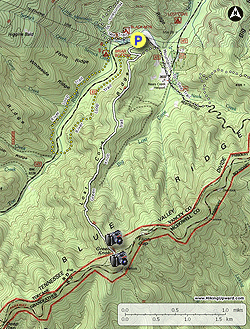
  • Mile 0.0 – Park at the hikers lot at the entrance of the Black Mountain Campground before the bridge over the South Toe River. The trails begin beside the information board. Initially you will follow the Green Knob Trail [182] (white blaze), River Loop Trail [200] (yellow blaze), and Mountains-to-Sea Trail [440] (white blaze).
  • Mile 0.3 – At a Y-junction turn right following the Green Knob Trail and River Loop Trail. The Mountains-to-Sea Trail turns left.
  • Mile 0.4 – Turn left at a Y-junction following the Green Knob Trail (white blaze). The River Loop Trail turns right. The next 2.5 miles is a continuous climb up Lost Cove Ridge.
  • Mile 2.3 – Begin following a narrow section of the ridge with views to the west.
  • Mile 2.8 – Pass by a viewpoint north of the mountains around the South Toe River Valley. The Black Mountains rise thousands of feet above the valley to the west. In the northern distance are the Roan Highlands, with Grandfather Mountain on the far right.
  • Mile 2.85 – Turn right at a T-junction on the short summit trail. The Green Knob Trail continues left dropping down to the Blue Ridge Parkway.
  • Mile 2.9 – Reach the lookout tower near the summit of Green Knob (5,060 feet). (The true summit is a few hundred feet to the north hidden in the trees.) The 21-foot lookout tower was built in 1931 and was rehabilitated in 1996. Although the door to the top cab is locked, you can still climb the stairs to get wonderful views of the Black Mountains and surrounding peaks. To the south you can see the Hickory Nut and Swannanoa Mountains. Graybeard Mountain and Pinnacle rise above the Blue Ridge Parkway to the southwest, with the Great Craggy Mountains poking up behind. Immediately west are the southern Black Mountains across the South Toe River Gorge. Mt. Mitchell, the tallest peak in the east, is the broad peak covered in dark conifer forests. The northern Black Mountains dominate the northwest horizon. You can see Celo Knob, the northernmost peak, from this vantage point.
  • Mile 5.6 – Hike ends at the Black Mountain Campground.
By HikingUpward Contributor: Zach Robbins
Explore 36 trails near Burnsville, NC
  1. Parking

    35.751199, -82.220119
  2. Main Trailhead

    35.751031, -82.220038
No community routes found. To add your own hike as a Community Route for this Trail guide, leave a Trip Report with an attached GPX file.

Hazards

Snakes
Poison Ivy/Oak

Seasons

All

Blaze Color

White

Photo Albums

+ Add Photo Album

Upload your photos from the trail to help others know what to expect.

Preview of the MyHikes mobile app interface

Track, Log, and Explore Hikes with the MyHikes App

Explore Autumn Foliage

No Change
Some Color
Low Color
Moderate Color
High Color
Peak Color
Past Peak
Sept 1 Sept 8 Sept 15 Sept 22 Sept 29 Oct 6 Oct 13 Oct 20 Oct 27 Nov 3 Nov 10 Nov 17 Nov 24

Trip Reports (Reviews)

Ready to help fellow hikers? Add a trip report to share your experience and provide valuable insights for those planning their next hike. Your review makes the trail better for everyone.

Rated 4.0 out of 5 based on 1 rating.
By: Justin
5.6 miles / 9.0 km
November 24, 2019
This hike ends with stunning views for miles. The breathtaking scenery is almost worth the sometimes vertical scrambles uphill. I think that the fallen leaves causing traction issues for the entire trail might have added to the danger and difficulty so choose a warmer month to take on this shorter but slow moving hike. Overall this is an awesome hike for experienced and prepared hikers. Trekking poles are a must.
Legacy Review

Weather Forecast

In Burnsville, NC

Explore Hiking Trails

You May Also Like

Colorado's Million Dollar Highway - Plan a day's drive adventure along the iconic Million Dollar Highway in Colorado. Explore the best short trails, roadside stops, waterfalls, vistas, ghost towns, and hot springs within a ~6 hour road trip.
Explore

Colorado's Million Dollar Highway

Plan a day's drive adventure along the iconic Million Dollar Highway in Colorado. Explore the best short trails, roadside stops, waterfalls, vistas, ghost towns, and hot springs within a ~6 hour road trip.

Read
Glacier's Going-to-the-Sun Road - Discover the breathtaking beauty of Glacier National Park along the iconic Going-to-the-Sun Road. From stunning roadside stops to picturesque waterfalls and vistas, this engineering marvel offers endless opportunities for exploration.
Explore

Glacier's Going-to-the-Sun Road

Discover the breathtaking beauty of Glacier National Park along the iconic Going-to-the-Sun Road. From stunning roadside stops to picturesque waterfalls and vistas, this engineering marvel offers endless opportunities for exploration.

Read
New York's Best Waterfalls - Whether you're planning a day hike, roadside stop, or a leisurely short walk, this guide provides hikers, travelers, and locals alike with 63 different locations to over 100 scenic waterfalls to help plan your next adventure!
Explore

New York's Best Waterfalls

Whether you're planning a day hike, roadside stop, or a leisurely short walk, this guide provides hikers, travelers, and locals alike with 63 different locations to over 100 scenic waterfalls to help plan your next adventure!

Read
25 Best Day Hikes in North Carolina - Discover the top 25 best day hikes in North Carolina, from breathtaking waterfalls to mountain peaks. Explore hidden gems, scenic views, and trails suitable for all skill levels, perfect for your next outdoor adventure.
Explore

25 Best Day Hikes in North Carolina

Discover the top 25 best day hikes in North Carolina, from breathtaking waterfalls to mountain peaks. Explore hidden gems, scenic views, and trails suitable for all skill levels, perfect for your next outdoor adventure.

Read

Before you boogie...

Find our trail guides useful? Consider becoming a Supporter to unlock perks!

MyHikes is an indie platform that makes exploring public trails easier for everyone. The platform has no investors, no ads, and is owned and operated by one person, Dave Miller. Dave has personally mapped and written over 1,800 trail guides on MyHikes for the public to explore. MyHikes has helped millions outdoor enthusiasts plan their next adventure.

But it takes a lot of time 🕦, money 💰, work, and espresso shots ☕ to run MyHikes, including hiking , mapping , writing , and publishing new trails with high-quality (accurate) information... along with software engineering (coding) the platform like building new features, website and mobile app development (iOS and Android), site maintainance . and much much more.

Supporters unlock website and mobile app perks with an annual one-time payment of $25 (you renew) 😎👍. Or you can simply make a Donation of your choice. Otherwise, you can support us by telling your friends about MyHikes - both quick and free 🎉

Admin user profile picture

Dave Miller
MyHikes Founder