The G Monument Trail at Uinta National Forest near Pleasant Grove, Utah is a difficult 1.9-mile out-and-back hike that leads to the large "G" that sits on the western foothills of Mt. Timpanogos and features views of Utah Lake, distant mountains, and the American Fork area.
Hike
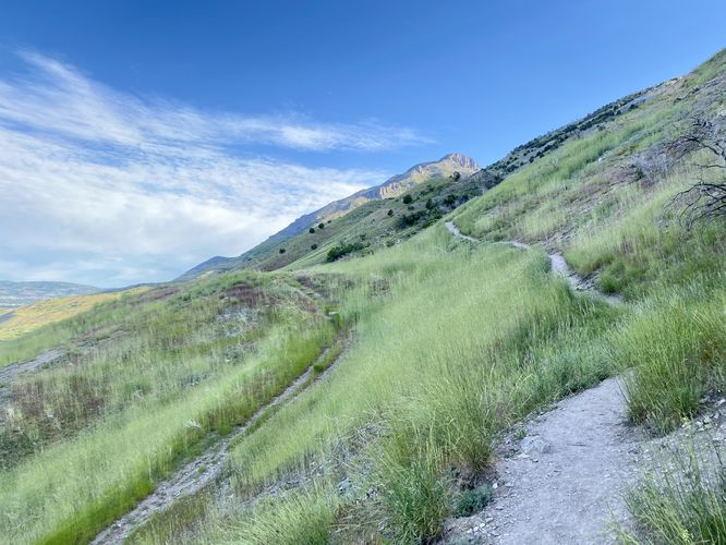
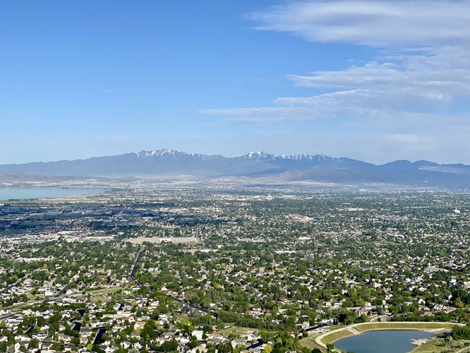
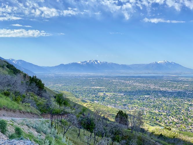
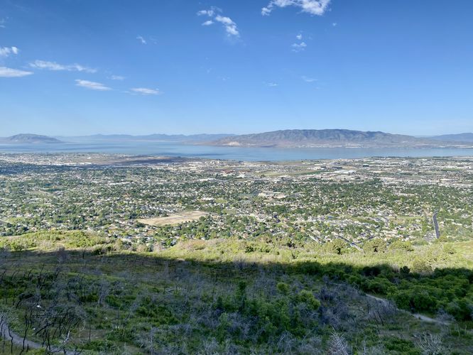
This hike begins at the main trailhead at Kiwanis Park in Pleasant Grove and follows one of two trails to head up to the G. During my hike here in late May 2024, there was an event going on at Kiwanis Park, so I avoided the crowds and followed the left-hand side trail -- turns out this is a scramble trail and it gets super steep. I'd recommend taking the right-hand side of the small loop in the route provided to avoid any scrambles or steep and loose-dirt terrain. Once on the main trail, it hits the most-difficult ascent in the entire hike which leads on from mile 0.1 to about 0.3. For this ~700-feet of hiking, the trails elevation grade is pretty brutal. After mile 0.3, the trails grade "eases up" just enough to continue toward the G for a difficult hike nonetheless. At mile 0.5, however, the trail's grade becomes even easier than before, which for most hikers is welcomed. Regardless of the trail's elevation grade, the elevation grade of the mountain slopes that the trail cuts along is very steep, so watch your step along this trail. On the way up, you'll find sweeping views of the greater Provo / American Fork area of Utah including vies of Utah Lake, Pleasant Grove, American Fork, Orem, Provo, and the surrounding mountains.
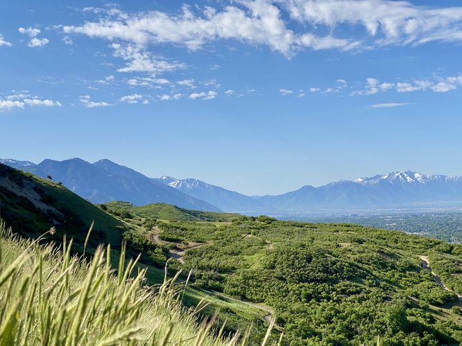
The trail eventually follows a far-less steep grade after mile 0.5 as it makes its way toward the G. Here, the trail begins to lead further away from the steep slopes of the mountain as it continues to climb uphill. You'll eventually enter an area of scrubland full of short trees and bushes before the trail begins to bend eastward around a large curve. You'll eventually follow this large curve to reach a switchback that ascends the final height to reach the G.
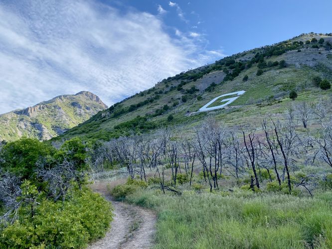
G Monument - Mile 0.95
Around mile 0.95, hikers will finally reach the G monument. From the top, you can choose to hike up the staircase that circles the monument (honestly, I felt sketched-out by the skinny stairs and super steep mountain grade) or you can chill out and enjoy the view from the large concrete benches that line the bottom of the G. Here, you'll find the same views that the trail provided from earlier, but you get a slightly different perspective with the trail below your feet, knowing you climbed all the way up to take-in the views. Sit and relax for as long as you wish before committing to the hike out.
Hiking Back - Mile 0.95 to 1.9
The hike back obviously follows the same trail. Most things to note -- keeping left on-trail will provide the easiest descent as there's a miniature "loop" half-way along the trail where the eastern side is more gradual with less loose rocks. And take the last 0.4 miles slow as this super steep grade can be tough, especially if there's any on-coming foot traffic. You'll complete the hike at the parking lot for a 1.9 mile out-and-back trek.
Parking
Hikers will find a very large parking lot at the coordinates provided, located next to Kiwanis Park in Pleasant Grove. The lot is large enough to fit a few dozen vehicles but it fills up quickly especially on weekends. You'll find overflow parking along the entrance road to the park.
Warning
Steep slopes: This trail follows very steep mountain slopes along what is sometimes, a very skinny pathway. Watch your step as there are no safety measures in-place along any of the mountain's slopes on-trail.
Rattlesnakes: During warm months, you may find rattlesnakes basking or sunbathing on-trail or in brush nearby. While rare, if you find any rattlers give them plenty of space.
Hike
This hike begins at the main trailhead at Kiwanis Park in Pleasant Grove and follows one of two trails to head up to the G. During my hike here in late May 2024, there was an event going on at Kiwanis Park, so I avoided the crowds and followed the left-hand side trail -- turns out this is a scramble trail and it gets super steep. I'd recommend taking the right-hand side of the small loop in the route provided to avoid any scrambles or steep and loose-dirt terrain. Once on the main trail, it hits the most-difficult ascent in the entire hike which leads on from mile 0.1 to about 0.3. For this ~700-feet of hiking, the trails elevation grade is pretty brutal. After mile 0.3, the trails grade "eases up" just enough to continue toward the G for a difficult hike nonetheless. At mile 0.5, however, the trail's grade becomes even easier than before, which for most hikers is welcomed. Regardless of the trail's elevation grade, the elevation grade of the mountain slopes that the trail cuts along is very steep, so watch your step along this trail. On the way up, you'll find sweeping views of the greater Provo / American Fork area of Utah including vies of Utah Lake, Pleasant Grove, American Fork, Orem, Provo, and the surrounding mountains.
The trail eventually follows a far-less steep grade after mile 0.5 as it makes its way toward the G. Here, the trail begins to lead further away from the steep slopes of the mountain as it continues to climb uphill. You'll eventually enter an area of scrubland full of short trees and bushes before the trail begins to bend eastward around a large curve. You'll eventually follow this large curve to reach a switchback that ascends the final height to reach the G.
G Monument - Mile 0.95
Around mile 0.95, hikers will finally reach the G monument. From the top, you can choose to hike up the staircase that circles the monument (honestly, I felt sketched-out by the skinny stairs and super steep mountain grade) or you can chill out and enjoy the view from the large concrete benches that line the bottom of the G. Here, you'll find the same views that the trail provided from earlier, but you get a slightly different perspective with the trail below your feet, knowing you climbed all the way up to take-in the views. Sit and relax for as long as you wish before committing to the hike out.
Hiking Back - Mile 0.95 to 1.9
The hike back obviously follows the same trail. Most things to note -- keeping left on-trail will provide the easiest descent as there's a miniature "loop" half-way along the trail where the eastern side is more gradual with less loose rocks. And take the last 0.4 miles slow as this super steep grade can be tough, especially if there's any on-coming foot traffic. You'll complete the hike at the parking lot for a 1.9 mile out-and-back trek.
Parking
Hikers will find a very large parking lot at the coordinates provided, located next to Kiwanis Park in Pleasant Grove. The lot is large enough to fit a few dozen vehicles but it fills up quickly especially on weekends. You'll find overflow parking along the entrance road to the park.
Warning
Steep slopes: This trail follows very steep mountain slopes along what is sometimes, a very skinny pathway. Watch your step as there are no safety measures in-place along any of the mountain's slopes on-trail.
Rattlesnakes: During warm months, you may find rattlesnakes basking or sunbathing on-trail or in brush nearby. While rare, if you find any rattlers give them plenty of space.