Loading...

WINTER SALE! 50% OFF Supporter Accounts — now through January 31st. Learn More.

Fryingpan Mountain Hike

Fryingpan Mountain is home to one of the tallest lookout towers in North Carolina at 70 feet. The mountain, at 5,342 feet, is part of the rugged Pisgah Ridge on the eastern front of the Great Balsam Mountains. This is a short, accessible hike for all ages from Fryingpan Gap on the Blue Ridge Parkway. You can also use a combination of trails emanating from Mount Pisgah Campground or Buck Spring Gap Overlook to create a longer day hike. Although the top cab of the tower is closed, you can still climb the steep stairs to get fantastic views in every direction. You’ll be blown away by the view of the Shining Rock Wilderness to the west, plus the other directions aren’t too shabby. Combined with Mount Pisgah, this short hike is a great way to orient yourself for further exploration of this region.

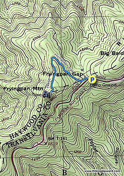
Parking at Fryingpan Gap - Park on the wide, grassy shoulders on the Blue Ridge Parkway around Fryingpan Gap. Do not block the gate. Parking here is limited since there is no parking lot. If the area is crowded, then you may need to park at the Mount Pisgah Campground which will be a 4.2-mile round trip. From the gap you’ll clearly see the lookout tower and communications tower overhead.

  • Mile 0.0 – Beginning at Fryingpan Gap walk around the gate and follow FR 450/Fryingpan Trail uphill to the left. The Fryingpan Trail also continues right heading towards Big Bald and the Mount Pisgah Campground. FR 450 climbs moderately up the mountain and is easy to follow.
  • Mile 0.8 – The forest road ends at the summit of Fryingpan Mountain (5,342 feet) between the lookout tower and communications tower. The 70-foot lookout tower was built in 1941 and is one of the tallest in the state. Climb the stairs to get fantastic views in every direction. You may want to secure any loose items before you climb, it can get very windy near the top. From the stairs the view north of Mount Pisgah is partially blocked by the communications tower, but below the summit you have an open view. The French Broad River Valley lies to the east with the Hickory Nut Mountains beyond. Towards the northeast you may be able to see the Great Craggy and Black Mountain ranges. Pisgah Ridge continues south towards Graveyard Fields, with Looking Glass Rock and other plutons visible to the left of the parkway. The central crest of the Great Balsam Mountains span the horizon from south to west. Black Balsam Knob is the tallest peak on the left, while Cold Mountain is the conical peak on the right.

  • Mile 1.6 – Hike ends back at Fryingpan Gap.

By HikingUpward Contributor: Zach Robbins
Explore 21 trails near Canton, NC

Know Before You Go

  • Fryingpan Mountain offers a short, accessible 1.6-mile hike to a 70-foot lookout tower with panoramic views of the surrounding mountains and valleys.
  • The trail starts at Fryingpan Gap on the Blue Ridge Parkway and follows FR 450/Fryingpan Trail to the summit, with limited parking available at the gap.
  • Despite the top cab being closed, climbing the tower stairs provides impressive views, including Shining Rock Wilderness, Mount Pisgah, and the Great Balsam Mountains.
Interactive topographic map for Fryingpan Mountain Hike located in Canton, NC. Click the "View Map" button to load GPS coordinates and trail markers.
Get directions
Distance
1.6 mi
Difficulty
Easy
Type
Out-and-Back
Est. Time
48 min
Elev. Gain
353'
Rating
0.0
Added
March 13, 2025
Updated
April 05, 2025

Weather Forecast

Loading...
Total Change
358'
Ascent
353'
Descent
356'
Loading...

Download the GPX Data for Offline Use

Supporters get exclusive access to download trail routes to the MyHikes app for offline use. Stay prepared on your adventure, even without an internet connection! Become a Supporter today to unlock this feature and hike with confidence.

Download Fryingpan Mountain Hike GPX Data to the MyHikes Mobile App

Features

Vista / Lookout Point
Dogs
Mountain Summit

Points of interest

  1. Parking

    35.395263, -82.768053
  2. Main Trailhead

    35.395263, -82.768053

Safety information

For your own safety: plan ahead, let someone know where you'll be, and hike at your own risk.

Hazards

Snakes (Rattlesnakes, Copperheads, others)
Poison Ivy or Poison Oak

Markers

Blaze Color

Blue

Availability

All seasons

Surface type

Dirt

Trip Reports (Reviews)

Your opinion matters! Be the first to rate this trail.

Ready to help fellow hikers? Add a trip report to share your experience and provide valuable insights for other hikers!

No community routes found. To add your own hike as a Community Route for this Trail guide, leave a Trip Report with an attached GPX file.

Popular categories

Scenic mountain view representing vista trails
Vista trails
Scenic gorge of cascades representing waterfall trails
Waterfall hikes
Rugged mountain terrain representing summit trails
Summit trails
Scenic mountain view representing dog-friendly trails
Dog-friendly
Scenic campsite with a view representing camping trails
Camping trails
Appalachian Trail logo representing A.T. hikes
A.T. hikes

You May Also Like

25 Best Day Hikes in North Carolina - Discover the top 25 best day hikes in North Carolina, from breathtaking waterfalls to mountain peaks. Explore hidden gems, scenic views, and trails suitable for all skill levels, perfect for your next outdoor adventure.
Explore

25 Best Day Hikes in North Carolina

Discover the top 25 best day hikes in North Carolina, from breathtaking waterfalls to mountain peaks. Explore hidden gems, scenic views, and trails suitable for all skill levels, perfect for your next outdoor adventure.

Read
Colorado's Million Dollar Highway - Plan a day's drive adventure along the iconic Million Dollar Highway in Colorado. Explore the best short trails, roadside stops, waterfalls, vistas, ghost towns, and hot springs within a ~6 hour road trip.
Explore

Colorado's Million Dollar Highway

Plan a day's drive adventure along the iconic Million Dollar Highway in Colorado. Explore the best short trails, roadside stops, waterfalls, vistas, ghost towns, and hot springs within a ~6 hour road trip.

Read
Glacier's Going-to-the-Sun Road - Discover the breathtaking beauty of Glacier National Park along the iconic Going-to-the-Sun Road. From stunning roadside stops to picturesque waterfalls and vistas, this engineering marvel offers endless opportunities for exploration.
Explore

Glacier's Going-to-the-Sun Road

Discover the breathtaking beauty of Glacier National Park along the iconic Going-to-the-Sun Road. From stunning roadside stops to picturesque waterfalls and vistas, this engineering marvel offers endless opportunities for exploration.

Read
🍪 We use cookies to learn about site usage and to serve map tiles. You may block cookies manually in the browser. By continuing you agree. Learn more