Loading...

WINTER SALE! 50% OFF Supporter Accounts — now through January 31st. Learn More.

Florence Nature Preserve Hike

Little Pisgah Mountain lacks the recognition of neighboring sights in the Hickory Nut Gorge but it may have the best view of them all. Tucked behind the Florence Nature Preserve, the mountain lies outside of an official trail system. It’s probably why most people have no idea it is an easy, albeit long road walk beyond the preserve. At the summit you’ll be treated to glorious 270° views north, east, and south of the rugged Hickory Nut Gorge and two of the tallest mountain ranges in North Carolina.

If you decide to forego the long hike and explore the nature preserve, you’ll still have a nice view from Rattlesnake Knob and see a surprisingly cool chute waterfall. Either way this is a spot worth checking out and is part of the push to expand hiking opportunities in the Hickory Nut Gorge.

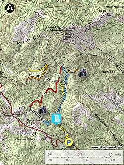
Note - The trails in the Florence Nature Preserve have no official names and are simply referred to by their blaze color. There are multiple trails with the same color so it is recommended to bring the trail map on your hike

  • Mile 0.0 – Hike starts at the Florence Nature Preserve parking area on U.S. 74A. Take the FNP Access Trail (Yellow Trail) which switchbacks quickly above the parking area.
  • Mile 0.9 – Rock hop a tributary to Hickory Creek entering the Florence Nature Preserve. The FNP Yellow Trail ends at a T-junction with the Blue Trail. Turn right heading north along the stream.
  • Mile 1.1 – Small cascade beside the trail.
  • Mile 1.3 – T-junction with the Yellow Trail on the left, continue straight on the Blue Trail.
  • Mile 1.7 – T-junction with the White Trail on the left, continue straight on the Blue Trail.
  • Mile 1.8 – T-junction with the Orange Trail (to Little Pisgah Point overlook) on the right. Turn right on the Orange Trail for the optional out-and-back to Little Pisgah Point.
  • Mile 2.0 – Orange Trail ends at Little Pisgah Point, a small hill covered in large boulders. Turn around to continue hiking on the Blue Trail.
  • Mile 2.3 – Veer right onto the Blue Trail.
  • Mile 2.4 – After crossing wide bridge turn left at a T-junction to begin the Red Trail. The Blue Trail continues straight to Little Pisgah Rd, which you can use to access the Orange Trail and Yellow Trail on the northwest parcel of the preserve.
  • Mile 2.7 – Four-way intersection with the White Trail, continue hiking on the Red Trail.
  • Mile 3.3 – Y-junction with the Orange Trail. Turn left for a quick out-and-back to Rattlesnake Knob.
  • Mile 3.4 – Orange Trail ends at Rattlesnake Knob, a series of rock outcrops with a nice view of the V-notched Hickory Nut Gap. Head back to the junction with the Red Trail.
  • Mile 3.6 – Turn left on the Red Trail.
  • Mile 3.9 – A forest road splits right off the Red Trail. Beyond this junction the Red Trail follows a forest road track beside private houses.
  • Mile 4.3 – Red Trail ends at the Blue Trail while the forest road curves right. Veer left following the Blue Trail. The Blue Trail climbs up and down multiple drainage divides separating tributaries to Hickory Creek.
  • Mile 4.6 – Directly before a bridge over a tributary look down to the right for a side path to a slot waterfall. The stream flows over a wide rock before plunging through a narrow chute. The scramble path leads to the slippery base of the chute waterfall.
  • Mile 4.8 – Cross a small bridge over a tributary with a cascade upstream.
  • Mile 4.9 – Turn right on the FNP Access Trail (Yellow Trail).
  • Mile 5.5 – Hike ends at the Florence Nature Preserve parking on U.S. 74A.
By HikingUpward Contributor: Zach Robbins
Explore 26 trails near Gerton, NC

Know Before You Go

  • Little Pisgah Mountain offers exceptional 270° views of Hickory Nut Gorge and surrounding mountain ranges, accessible via a longer road walk beyond Florence Nature Preserve.
  • Florence Nature Preserve provides alternative shorter hikes with views from Rattlesnake Knob and a unique chute waterfall.
  • Navigating Florence Nature Preserve requires a trail map due to multiple trails sharing blaze colors.
Interactive topographic map for Florence Nature Preserve Hike located in Gerton, NC. Click the "View Map" button to load GPS coordinates and trail markers.
Get directions
Distance
5.4 mi
Difficulty
Moderate
Type
Loop
Est. Time
2.7 hrs
Elev. Gain
1,530'
Rating
3.0
Added
March 22, 2025
Updated
April 06, 2025

Weather Forecast

Loading...
Total Change
908'
Ascent
1,530'
Descent
1,522'
Loading...

Download the GPX Data for Offline Use

Supporters get exclusive access to download trail routes to the MyHikes app for offline use. Stay prepared on your adventure, even without an internet connection! Become a Supporter today to unlock this feature and hike with confidence.

Download Florence Nature Preserve Hike GPX Data to the MyHikes Mobile App

Features

Vista / Lookout Point
Dogs
Waterfalls
Water Source

Points of interest

  1. Parking

    35.473403, -82.332291
  2. Main Trailhead

    35.473428, -82.332187

Safety information

For your own safety: plan ahead, let someone know where you'll be, and hike at your own risk.

Hazards

Snakes (Rattlesnakes, Copperheads, others)
Poison Ivy or Poison Oak

Availability

All seasons

Surface type

Dirt

Trip Reports (Reviews)

Rated 3.0 out of 5 based on 1 rating.

Ready to help fellow hikers? Add a trip report to share your experience and provide valuable insights for other hikers!

By: Rebekah
5.4 miles / 8.7 km
September 20, 2019
Pros: The trails are clearly marked and directions extremely easy to follow. It’s a quick somewhat steep 1 mile up, but well maintained and stairs in necessary areas. Easy for any average hiker. 95% of the trails are well shaded. Lots of creeks and tributaries with mini waterfalls in a few places. Bridges built for any necessary crossings. The trail is moderate and the 5.8 mile loop was quiet and peaceful. Only saw 3 hikers at the beginning and 3 more at the end. Because it is several trails connected, I’m guessing most people don’t do the red, orange and blue trails.Cons: the 270 degree views mentioned at the top are not found on this 5.8 mile loop. The first orange trail leads you to a rock growth but too many trees to get any view at all. The second orange trail takes you in and out to two more rock formations at the summer. Only one gives about a 30 degree view of a few mountains in the distance. The area is small so it’s a good thing the trail is quiet, as it wouldn’t hold more than 3-4 people for viewingAll in all a very well-maintained hike. A moderate nearly 6 mile hike that is great for breathing in some fresh air in a peaceful quiet setting. Took about 3 hours to complete with a 30 minute break at the top. Just wish the views had been what I was expecting.
Legacy Review
No community routes found. To add your own hike as a Community Route for this Trail guide, leave a Trip Report with an attached GPX file.

Popular categories

Scenic mountain view representing vista trails
Vista trails
Scenic gorge of cascades representing waterfall trails
Waterfall hikes
Rugged mountain terrain representing summit trails
Summit trails
Scenic mountain view representing dog-friendly trails
Dog-friendly
Scenic campsite with a view representing camping trails
Camping trails
Appalachian Trail logo representing A.T. hikes
A.T. hikes

You May Also Like

25 Best Day Hikes in North Carolina - Discover the top 25 best day hikes in North Carolina, from breathtaking waterfalls to mountain peaks. Explore hidden gems, scenic views, and trails suitable for all skill levels, perfect for your next outdoor adventure.
Explore

25 Best Day Hikes in North Carolina

Discover the top 25 best day hikes in North Carolina, from breathtaking waterfalls to mountain peaks. Explore hidden gems, scenic views, and trails suitable for all skill levels, perfect for your next outdoor adventure.

Read
Colorado's Million Dollar Highway - Plan a day's drive adventure along the iconic Million Dollar Highway in Colorado. Explore the best short trails, roadside stops, waterfalls, vistas, ghost towns, and hot springs within a ~6 hour road trip.
Explore

Colorado's Million Dollar Highway

Plan a day's drive adventure along the iconic Million Dollar Highway in Colorado. Explore the best short trails, roadside stops, waterfalls, vistas, ghost towns, and hot springs within a ~6 hour road trip.

Read
Glacier's Going-to-the-Sun Road - Discover the breathtaking beauty of Glacier National Park along the iconic Going-to-the-Sun Road. From stunning roadside stops to picturesque waterfalls and vistas, this engineering marvel offers endless opportunities for exploration.
Explore

Glacier's Going-to-the-Sun Road

Discover the breathtaking beauty of Glacier National Park along the iconic Going-to-the-Sun Road. From stunning roadside stops to picturesque waterfalls and vistas, this engineering marvel offers endless opportunities for exploration.

Read
🍪 We use cookies to learn about site usage and to serve map tiles. You may block cookies manually in the browser. By continuing you agree. Learn more