Loading...

🎉 Enjoy a Free 7-Day Supporter Trial and Unlock Exclusive Perks — No Credit Card Required. Learn more.

Flat Top Tower Hike

Directions
Map
Pictures
Send to App
Distance:
5.2 Miles / 8.4 km
Type:
Out-and-Back
Difficulty:
Easy
Time to Hike:
2 hours, ~36 minutes
Features:
Surface Type:
Dirt
Town:
Blowing Rock, North Carolina
Directions:
36.149281, -81.692878
Added:
March 22, 2025
Updated:
April 06, 2025
Copy Trail Link Hiking this trail? Send a friend or family member a link to this trail guide for your own safety. Hike at your own risk (disclaimer)
Loading...
Loading...
568'

Total Change
620'

Ascent
622'

Descent

Download the Trail Route for Offline Use

Supporters get exclusive access to download trail routes to the MyHikes app for offline use. Stay prepared on your adventure, even without an internet connection! Become a Supporter today to unlock this feature and hike with confidence.

Send to App

Flat Top Tower Hike

Any hike at Moses H. Cone Memorial Park packs many views into relatively easy terrain and mileage for the Blue Ridge Mountains. Located just outside of Blowing Rock on the Blue Ridge Parkway, this estate was donated to the National Park Service in 1949 after the death of Bertha Cone. Prior to being controlled by the NPS, Moses Cone and his wife retired to this estate building over 20 miles of carriage trails, three lakes, and an observation tower on the highest point in the estate, Flat Top Mountain.

Today the park is an excellent destination for hikers, horseback rides, and motorists. The carriage trails are all immaculately maintained and well-graded. None of the hikes in the park are difficult so it is perfect for the family and casual hikers. This hike starts at Flat Top Manor and winds through picturesque forest and fields for 2.6 miles to the observation tower on Flat Top Mountain. You will be treated to incredible views from a meadow near Cone Cemetery and 360° views from Flat Top Tower. Moses H. Cone Memorial Park is an outstanding introduction to the Blue Ridge Mountains for the family.

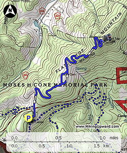
  • Mile 0.0 – Hike begins at the parking lot for Flat Top Manor. You can pick up a free map in the house and explore the displays. The house has a grand porch overlooking Bass Lake and the lower elevations of the park. Go left following the paved trail towards the Blue Ridge Parkway.
  • Mile 0.2 – Pass through a stone tunnel under the Blue Ridge Parkway. On the other side of the tunnel the trail splits. The trail on the left leads to Trout Lake and Rich Mountain. Stay right to follow Flat Top Road. The carriage road winds gently through forest.
  • Mile 1.0 – Enter a vast meadow and intersect a spur trail on the left to Cone Cemetery. Turn left for a short side trip.
  • Mile 1.1 – Pass through a ring of trees surrounding the Cone Cemetery, the grave is enclosed by a fence and there is a plaque on the back side documenting the life of Moses Cone. The trail continues beyond the trees and connects back with the main trail.
  • Mile 1.2 – Reconnect with Flat Top Rd which winds gracefully through the meadow. You will spot multiple side footpaths taking the short route straight up the hill. Avoid these footpaths, they are not part of the trail system and cause erosion. Instead enjoy the longer, easier route on the carriage trail. On this stretch you will get fantastic views southwest of Rich Mountain, Grandfather Mountain, Sugar Mountain, and Hanging Rock. Towards the east you will see the houses of Blowing Rock dotting the hills.
  • Mile 1.5 – Leave the meadow and enter the forested southern slope of Flat Top Mountain.
  • Mile 1.9 – Pass through a thick section of rhododendron, a small outcrop on the right offers a view of Blowing Rock.
  • Mile 2.0 – A stone wall lines the trail and leads to a wide open view to the southeast of Blowing Rock.
  • Mile 2.7 – Trail ends at the forested summit of Flat Top Mountain. Flat Top Tower adorns the summit. This tower was originally built in 1900 from wood but after severe deterioration was torn down and the present day 40-foot Aermotor tower was built in 1954. This tower is always open, climb the stairs for the fantastic 360° views from the top.

    Due southwest Grandfather Mountain dominates the surroundings. The mountain impressively rises over the region and this is one of the best views you will find of Calloway Peak. Immediately to the right of Grandfather Mountain the condominium building on Sugar Mountain is plainly visible with the pointed summit of Hanging Rock to the right. The Roan Highlands can be spotted in the distant west between Sugar Mountain and Hanging Rock. On the right of Hanging Rock in the northwest you will see the elongated ridgeline and ski slopes of Beech Mountain. To the north the high, rugged peaks of the Amphibolite Range rise above Boone and the Watauga Valley.  The sharp topped peak on the left is Snake Mountain and the large rounded peak in the center is Elk Knob, the two tallest mountains in the range. On a clear day you may be able to spot Mt. Rogers in Virginia far north. Blowing Rock lies far below the summit to the southeast. Due south you will see the large meadow with Cone Cemetery, the peaks of Linville Gorge are visible in the distance.

  • Mile 5.2 – Hike ends at Flat Top Manor parking lot.
By HikingUpward Contributor: Zach Robbins
Explore 25 trails near Blowing Rock, NC
  1. Parking

    36.149281, -81.692878
  2. Main Trailhead

    36.149497, -81.692297
No community routes found. To add your own hike as a Community Route for this Trail guide, leave a Trip Report with an attached GPX file.

Hazards

Snakes
Poison Ivy/Oak

Seasons

All

Trip Reports

Trail Guide By:
HikingUpward user profile picture
5.2 miles / 8.4 km

Weather Forecast

In Blowing Rock, NC

Explore Hiking Trails

You May Also Like

Colorado's Million Dollar Highway - Plan a day's drive adventure along the iconic Million Dollar Highway in Colorado. Explore the best short trails, roadside stops, waterfalls, vistas, ghost towns, and hot springs within a ~6 hour road trip.
Explore

Colorado's Million Dollar Highway

Plan a day's drive adventure along the iconic Million Dollar Highway in Colorado. Explore the best short trails, roadside stops, waterfalls, vistas, ghost towns, and hot springs within a ~6 hour road trip.

Read
Glacier's Going-to-the-Sun Road - Discover the breathtaking beauty of Glacier National Park along the iconic Going-to-the-Sun Road. From stunning roadside stops to picturesque waterfalls and vistas, this engineering marvel offers endless opportunities for exploration.
Explore

Glacier's Going-to-the-Sun Road

Discover the breathtaking beauty of Glacier National Park along the iconic Going-to-the-Sun Road. From stunning roadside stops to picturesque waterfalls and vistas, this engineering marvel offers endless opportunities for exploration.

Read
New York's Best Waterfalls - Whether you're planning a day hike, roadside stop, or a leisurely short walk, this guide provides hikers, travelers, and locals alike with 63 different locations to over 100 scenic waterfalls to help plan your next adventure!
Explore

New York's Best Waterfalls

Whether you're planning a day hike, roadside stop, or a leisurely short walk, this guide provides hikers, travelers, and locals alike with 63 different locations to over 100 scenic waterfalls to help plan your next adventure!

Read
25 Best Day Hikes in North Carolina - Discover the top 25 best day hikes in North Carolina, from breathtaking waterfalls to mountain peaks. Explore hidden gems, scenic views, and trails suitable for all skill levels, perfect for your next outdoor adventure.
Explore

25 Best Day Hikes in North Carolina

Discover the top 25 best day hikes in North Carolina, from breathtaking waterfalls to mountain peaks. Explore hidden gems, scenic views, and trails suitable for all skill levels, perfect for your next outdoor adventure.

Read

Before you boogie...

Find our trail guides useful? Consider becoming a Supporter to unlock perks!

MyHikes is an indie platform that makes exploring public trails easier for everyone. The platform has no investors, no ads, and is owned and operated by one person, Dave Miller. Dave has personally mapped and written over 1,800 trail guides on MyHikes for the public to explore. MyHikes has helped millions outdoor enthusiasts plan their next adventure.

But it takes a lot of time 🕦, money 💰, work, and espresso shots ☕ to run MyHikes, including hiking , mapping , writing , and publishing new trails with high-quality (accurate) information... along with software engineering (coding) the platform like building new features, website and mobile app development (iOS and Android), site maintainance . and much much more.

Supporters unlock website and mobile app perks with an annual one-time payment of $25 (you renew) 😎👍. Or you can simply make a Donation of your choice. Otherwise, you can support us by telling your friends about MyHikes - both quick and free 🎉

Admin user profile picture

Dave Miller
MyHikes Founder