Loading...

WINTER SALE! 50% OFF Supporter Accounts — now through January 31st. Learn More.

Elk Knob Hike

Elk Knob State Park is one of the newest state parks in North Carolina and also one of the smallest. The trail system may be minimal, but the Summit Trail is one of the finest trails in the state park system. The immaculately built trail winds its way for 1.9 miles through entrancing northern hardwood forests to the summit of Elk Knob, the second tallest mountain in the Amphibolite Range.

Most of the land in the Amphibolite Range is privately owned and there isn’t much public land available for hiking. Fortunately Elk Knob is available for the public to explore and the views encompass some of the highest peaks in NC, TN, and VA. At just under 4 miles round trip this is a great half-day hike for the family and those wishing to discover the extreme northwest corner of North Carolina.

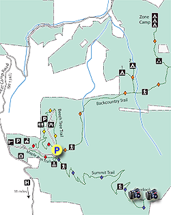
  • Mile 0.0 – At the main parking area beside the amphitheater, find the Summit Trail (blue diamond blaze) and begin climbing gently through the forest.
  • Mile 0.6 – Trail crosses a service road that climbs directly to the summit. Throughout the hike you will cross the service road multiple times, but resist the temptation to use this old road as a shortcut. It is overgrown, exposed to the sun, and steep. The recently built trail is well-graded and winds through beautiful forest.
  • Mile 1.0 – At a tight curve pass by a bench with a view through the trees of The Peak.
  • Mile 1.1 – Second junction with the service road.
  • Mile 1.3 – Third junction with the service road.
  • Mile 1.5 – Fourth junction with the service road.
  • Mile 1.7 – As you approach the summit the gnarled forest gives way to swaths of flame azaleas that typically bloom in early June.
  • Mile 1.8 – Reach a T-junction with the service road. A sign will indicate North View and South View. Turn right for the North View first, which is the highest point of the mountain. Although the window between the trees is small, you have close to a 180° view of the northern Amphibolite Range. The Peak is the most prominent mountain in view with its craggy, imposing conical summit. In the distance beyond The Peak lies the Iron Mountains, the tallest peaks in Virginia including Whitetop Mountain and Mount Rogers immediately left of The Peak’s summit. To the right the gentle, bare Old Field Bald is in the foreground with Bluff Mountain, Three Top Mountain, and Mt. Jefferson rising behind. Turn around and head down the trail to the South View.
  • Mile 1.9 – The South View is much more expansive than the North View as trees give way to dense collection of flame azaleas. Snake Mountain, the tallest peak in the Amphibolite Range, is the closest peak on the right with its elongated ridge. To the left of Snake Mountain is Rich Mountain with its extensive balds visible above Rich Mountain Gap. In the distance to the left of Rich Mountain are the Roan Highlands. Straight ahead the Watauga Valley lies in front of the massive Grandfather Mountain looming far behind. The sawtooth peaks between Grandfather Mountain and the Roan Highlands are Hanging Rock and the ski areas of Sugar Mountain and Beech Mountain.    
  • Mile 2.0 - Retrace your steps and follow the Summit Trail back down to the parking lot.
  • Mile 3.9 – Hike ends at the parking lot.
By HikingUpward Contributor: Zach Robbins
Explore 31 trails near Todd, NC

Know Before You Go

  • Elk Knob State Park's Summit Trail is a well-maintained 3.9-mile roundtrip hike through northern hardwood forests to the summit of Elk Knob, offering excellent views despite the park's small size.
  • The trail crosses a service road multiple times; however, hikers should stay on the Summit Trail to avoid a steep, exposed, and overgrown path.
  • The summit offers both North and South views encompassing peaks in North Carolina, Tennessee, and Virginia, including notable mountains like Snake Mountain, Grandfather Mountain, and peaks in the Iron Mountains.
Interactive topographic map for Elk Knob Hike located in Todd, NC. Click the "View Map" button to load GPS coordinates and trail markers.
Get directions
Distance
3.9 mi
Difficulty
Moderate
Type
Out-and-Back
Est. Time
2 hrs
Elev. Gain
1,053'
Rating
0.0
Added
March 22, 2025
Updated
April 06, 2025

Weather Forecast

Loading...
Total Change
985'
Ascent
1,053'
Descent
1,053'
Loading...

Download the GPX Data for Offline Use

Supporters get exclusive access to download trail routes to the MyHikes app for offline use. Stay prepared on your adventure, even without an internet connection! Become a Supporter today to unlock this feature and hike with confidence.

Download Elk Knob Hike GPX Data to the MyHikes Mobile App

Features

Vista / Lookout Point
Dogs
Mountain Summit

Points of interest

  1. Parking

    36.331706, -81.689279
  2. Main Trailhead

    36.33205, -81.689487

Safety information

For your own safety: plan ahead, let someone know where you'll be, and hike at your own risk.

Hazards

Snakes (Rattlesnakes, Copperheads, others)
Poison Ivy or Poison Oak

Markers

Blaze Color

Blue

Availability

All seasons

Surface type

Dirt

Trip Reports (Reviews)

Your opinion matters! Be the first to rate this trail.

Ready to help fellow hikers? Add a trip report to share your experience and provide valuable insights for other hikers!

No community routes found. To add your own hike as a Community Route for this Trail guide, leave a Trip Report with an attached GPX file.

Popular categories

Scenic mountain view representing vista trails
Vista trails
Scenic gorge of cascades representing waterfall trails
Waterfall hikes
Rugged mountain terrain representing summit trails
Summit trails
Scenic mountain view representing dog-friendly trails
Dog-friendly
Scenic campsite with a view representing camping trails
Camping trails
Appalachian Trail logo representing A.T. hikes
A.T. hikes

You May Also Like

25 Best Day Hikes in North Carolina - Discover the top 25 best day hikes in North Carolina, from breathtaking waterfalls to mountain peaks. Explore hidden gems, scenic views, and trails suitable for all skill levels, perfect for your next outdoor adventure.
Explore

25 Best Day Hikes in North Carolina

Discover the top 25 best day hikes in North Carolina, from breathtaking waterfalls to mountain peaks. Explore hidden gems, scenic views, and trails suitable for all skill levels, perfect for your next outdoor adventure.

Read
Colorado's Million Dollar Highway - Plan a day's drive adventure along the iconic Million Dollar Highway in Colorado. Explore the best short trails, roadside stops, waterfalls, vistas, ghost towns, and hot springs within a ~6 hour road trip.
Explore

Colorado's Million Dollar Highway

Plan a day's drive adventure along the iconic Million Dollar Highway in Colorado. Explore the best short trails, roadside stops, waterfalls, vistas, ghost towns, and hot springs within a ~6 hour road trip.

Read
Glacier's Going-to-the-Sun Road - Discover the breathtaking beauty of Glacier National Park along the iconic Going-to-the-Sun Road. From stunning roadside stops to picturesque waterfalls and vistas, this engineering marvel offers endless opportunities for exploration.
Explore

Glacier's Going-to-the-Sun Road

Discover the breathtaking beauty of Glacier National Park along the iconic Going-to-the-Sun Road. From stunning roadside stops to picturesque waterfalls and vistas, this engineering marvel offers endless opportunities for exploration.

Read
🍪 We use cookies to learn about site usage and to serve map tiles. You may block cookies manually in the browser. By continuing you agree. Learn more