Loading...

❄️ WINTER SALE! 50% OFF on Supporter Accounts — now through January 31st. Unlock a full year of exclusive website & app perks. Learn More.

Duncan Knob Hike

Along with sister hike Duncan Knob Hollow, Duncan Knob climbs Catback Mountain in the Massanutten Range offering solitude, a rock scramble, and great views of the Massanutten Range and Shenandoah Valley. 
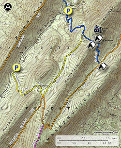
Choose from this route along 3.6 miles out-and-back to the Duncan Knob summit from Gap Creek, or make the longer 8.5 mile circuit hike from Scothorn Gap. There are multiple good camp sites on both hikes, including a site at the summit with gorgeous sunset views to the southwest.

Gap Creek - Out/Back - 3.5 Miles

  • Mile 0.0 - From the parking area along Crisman Hollow Rd follow the side track and blue blazed Gap Creek Trail for 100 yards to the first campsite on the left. At this point the Gap Creek Trail turns left and crosses a wooden footbridge over Gap Creek. The trail is initially rocky as it climbs Catback Mountain. Make six switchbacks in the first 1.2 miles then arrive at the intersection of the yellow blazed Scothorn Gap Trail that comes in from the right.
  • Mile 1.2 - Continue climbing on the blue blazed Gap Creek trail for another 0.3 miles to Peach Orchard Gap where there is a large campsite. The white blazed Duncan Knob Overlook Trail is on the left in the saddle.
  • Mile 1.5 - Turn left onto the white blazed trail then in 0.1 miles pass a campsite on the right. After the campsite the trail becomes more rocky and harder to follow. Look for rock cairns to guide you. As the trail enters the rock slide below Duncan Knob stay to the left and around the largest bolder in the field before heading uphill to the ridge. At the ridge there is a small campsite suitable for a single tent. Follow the trail right to the overlook.
  • Mile 1.8 - From the overlook there are expansive views to the south of the Shenandoah Valley and west towards New Market Gap. Return back to the intersection with the Gap Creek Trail at Peach Orchard Gap.
  • Mile 2.1 - Turn right downhill on the blue blazed Gap Creek Trail retracing your route back to the parking area on Crisman Hollow Rd.
  • Mile 3.5 - Arrive back at the parking are on Crisman Hollow Rd.
Explore 104 trails near Mount Jackson, VA

Know Before You Go

  • The Duncan Knob hike in Mount Jackson, VA offers a 3.5-mile out-and-back trail to the summit with scenic views of the Massanutten Range and Shenandoah Valley.
  • The trail includes a rock scramble section that can be challenging to navigate, requiring hikers to look for rock cairns for guidance.
  • There are multiple campsites available along the trail, including one at the summit with southwest-facing sunset views, making it suitable for overnight trips.
Interactive topographic map for Duncan Knob Hike located in Mount Jackson, VA. Click the "View Map" button to load GPS coordinates and trail markers.
Get directions
Distance
3.5 mi
Difficulty
Moderate
Type
Out-and-Back
Est. Time
1.8 hrs
Elev. Gain
1,152'
Rating
3.8
Added
January 25, 2025
Updated
April 04, 2025

Weather Forecast

Loading...
Total Change
1,130'
Ascent
1,152'
Descent
1,152'
Loading...

Download the GPX Data for Offline Use

Supporters get exclusive access to download trail routes to the MyHikes app for offline use. Stay prepared on your adventure, even without an internet connection! Become a Supporter today to unlock this feature and hike with confidence.

Download Duncan Knob Hike GPX Data to the MyHikes Mobile App

Features

Vista / Lookout Point
Dogs
Mountain Summit
Camping

Points of interest

  1. Parking

    38.708681, -78.560376
  2. Main Trailhead

    38.708681, -78.560376

Safety information

For your own safety: plan ahead, let someone know where you'll be, and hike at your own risk.

Hazards

Snakes (Rattlesnakes, Copperheads, others)
Poison Ivy or Poison Oak

Markers

Blaze Color

Blue

Availability

All seasons

Surface type

Dirt

Trip Reports (Reviews)

Rated 3.84 out of 5 based on 68 ratings.

Ready to help fellow hikers? Add a trip report to share your experience and provide valuable insights for other hikers!

3.5 miles / 5.6 km
July 02, 2025
Hiking
By: AElsey
3.5 miles / 5.6 km
October 13, 2019
Yes a lot of rocks and gnats like the other reviewer said but who cares. Its a natural thing and to be expected, no one to blame but God and mother nature, suck it up. The hikes were no joke, if you are not in shape or want to get in shape then do the long trail around. No matter what you do the view at the top is worth it and you will need to earn that satisfaction. The camping spots along the way were really nice. We were very lucky to have perfect weather and the moon was shining on both nights. We will be going back.
Legacy Review
By: Katy J
3.5 miles / 5.6 km
August 27, 2019
This hike could have been much better if there were less gnats or we had been wearing bug spray! We parked at the Gap Creek trail head. Until the orange-yellow blazed trail came in from the right a mile or so up the trail, the gnats were pretty horrific. We couldn't stand still for any length of time and the going was almost always UP! There were many loose rocks along the trail which prohibited looking around along the way, although the scenery was not much to look at. Much of the forest had been burned and trees were down in many places. Once we reached the boulder-sized rocks cascading down from the top, we noticed there were rock piles to help guide us along the way, but there were many, many rocks to climb up, and we decided to turn back before reaching the top. It seemed like an endless task of going slowly and carefully. Perhaps for those who are experienced at lengthy rock scrambles, this climb would not be an issue, but for me, it was a bit much. We found a flat rock half way up the rock scramble to eat our lunch. The view was fairly good from here. I realized, there were no pictures from this hike because of all the gnats and intense walking due to either loose rocks along the trail, or the expansive boulder rock climb.
Legacy Review
No community routes found. To add your own hike as a Community Route for this Trail guide, leave a Trip Report with an attached GPX file.

Popular categories

Scenic mountain view representing vista trails
Vista trails
Scenic gorge of cascades representing waterfall trails
Waterfall hikes
Rugged mountain terrain representing summit trails
Summit trails
Scenic mountain view representing dog-friendly trails
Dog-friendly
Scenic campsite with a view representing camping trails
Camping trails
Appalachian Trail logo representing A.T. hikes
A.T. hikes

You May Also Like

25 Best Day Hikes in North Carolina - Discover the top 25 best day hikes in North Carolina, from breathtaking waterfalls to mountain peaks. Explore hidden gems, scenic views, and trails suitable for all skill levels, perfect for your next outdoor adventure.
Explore

25 Best Day Hikes in North Carolina

Discover the top 25 best day hikes in North Carolina, from breathtaking waterfalls to mountain peaks. Explore hidden gems, scenic views, and trails suitable for all skill levels, perfect for your next outdoor adventure.

Read
🍪 We use cookies to learn about site usage and to serve map tiles. You may block cookies manually in the browser. By continuing you agree. Learn more