Loading...

WINTER SALE! 50% OFF Supporter Accounts — now through January 31st. Learn More.

Duncan Knob Hollow Hike

The Duncan Knob Hollow hike is essentially the same circuit as the Duncan Knob Hike, except starting from the other side of Middle Mountain. This hike is also longer, with several excellent multi-tent camping sites, and is accessible in the winter and late spring months when FDR674/VA211 is closed.

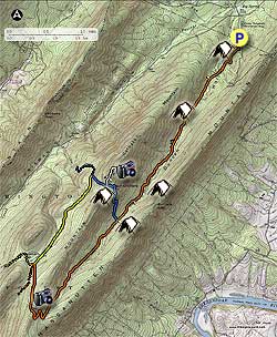
Start south on the orange blazed Massanutten Trail as it winds along the valley on the east side of Little Passage Creek. Cross a small wooded footbridge placed over one of the side streams, and come to the first of three crossing points on Little Passage Creek in 0.7 miles.

After crossing Little Passage Creek, pass the second campsite on the opposite bank (the first campsite is 100 yards from the trailhead). Continue up the valley on the orange blazed trail and pass a small seasonal spring in another 1.0 miles. In 1.1 miles from the spring is the best multi-tent campsite on the circuit, right on the banks of Little Passage Creek. This campsite has a large fire pit with several stone seats.

After passing the campsite cross Little Passage Creek, then back again, and continue 0.3 miles to the intersection of the blue blazed Gap Creek Trail. On the left/east bank of Little passage Creek is another multi-tent campsite with a large fire pit and stone seats.

From the orange blazed Massanutten Trail, turn right uphill on the blue blazed Gap Creek Trail for the steepest section of the route. In 0.8 miles arrive at the ridge of Middle Mountain, and third multi-tent campsite.

Turn right on the white blazed trail that leads up to Duncan Knob. In 0.1 miles there is a multi-tent campsite on the right of the trail, and single tent campsite on the left. In another 100 yards from these campsites enter the rock slide portion of the white blazed trail. The blazes can be hard to locate during the rock scramble to the summit. At the top of the rock slide, stay right to the Duncan Knob vista.

After returning to the saddle, and blue blazed Gap Creek Trail, turn right downhill on the west side if the mountain, and in 0.3 miles reach the intersection of the yellow blazed Scothorn Gap Trail. Turn left on the yellow blazed trail and in 0.6 miles pass through a small clearing. In 1.0 mile from the clearing reach at the four way intersection of the Massanutten Trail. The Massanutten Trail comes in from the left and continues straight, and the Scothorn Gap Trail turns right.

Turn left uphill on the orange blazed Massanutten Trail and arrive the ridge line in 0.7 miles. At the ridge there is a nice vista point 100 yards off the trail to the left/north. Continue downhill 0.4 miles on the east side of Middle Mountain as the orange blazed trail steeply descends to the valley, then makes a turn back to the left/north where the descent is less steep.

From the left turn, continue on the trail for 1.8 miles back to the intersection of the Gap Creek Trail. From this point continue straight on the orange blazed Massanutten Trail, retracing your steps across Little passage Creek three times, and arriving back at the trailhead and VA675 in 3.1 miles.

Explore 103 trails near Luray, VA

Know Before You Go

  • The Duncan Knob Hollow hike is a 12.2-mile loop, similar to the Duncan Knob Hike but starts on the opposite side of Middle Mountain and offers winter/late spring accessibility when other routes are closed.
  • The trail features several multi-tent campsites along Little Passage Creek and on Middle Mountain, with some equipped with fire pits and stone seats.
  • The hike includes varied terrain, from valley trails with stream crossings to a steep ascent on the Gap Creek Trail, a rock scramble to Duncan Knob vista, and a descent on the Scothorn Gap Trail.
Interactive topographic map for Duncan Knob Hollow Hike located in Luray, VA. Click the "View Map" button to load GPS coordinates and trail markers.
Get directions
Distance
12.2 mi
Difficulty
Hard
Type
Loop
Est. Time
6.1 hrs
Elev. Gain
1,832'
Rating
3.8
Added
January 25, 2025
Updated
April 04, 2025

Weather Forecast

Tonight
Low 15°F
Slight Chance Freezing Drizzle then Partly Cloudy
Monday
High 24°F
Mostly Sunny
Monday Night
Low -4°F
Mostly Clear
Tuesday
High 29°F
Sunny
Tuesday Night
Low 1°F
Partly Cloudy
Wednesday
High 21°F
Mostly Sunny
Wednesday Night
Low -2°F
Mostly Cloudy
Thursday
High 18°F
Mostly Sunny
Thursday Night
Low -4°F
Partly Cloudy
Friday
High 17°F
Mostly Sunny
Friday Night
Low -2°F
Mostly Clear
Saturday
High 22°F
Mostly Sunny
Saturday Night
Low 1°F
Mostly Clear
Sunday
High 28°F
Sunny
Loading...
Total Change
1,465'
Ascent
1,832'
Descent
1,830'
Loading...

Download the GPX Data for Offline Use

Supporters get exclusive access to download trail routes to the MyHikes app for offline use. Stay prepared on your adventure, even without an internet connection! Become a Supporter today to unlock this feature and hike with confidence.

Download Duncan Knob Hollow Hike GPX Data to the MyHikes Mobile App

Features

Vista / Lookout Point
Dogs
Mountain Summit
Camping

Points of interest

  1. Parking

    38.728208, -78.516983
  2. Main Trailhead

    38.728127, -78.517141

Safety information

For your own safety: plan ahead, let someone know where you'll be, and hike at your own risk.

Hazards

Snakes (Rattlesnakes, Copperheads, others)
Poison Ivy or Poison Oak

Availability

All seasons

Surface type

Dirt

Trip Reports (Reviews)

Rated 3.8 out of 5 based on 46 ratings.

Ready to help fellow hikers? Add a trip report to share your experience and provide valuable insights for other hikers!

By: Ron
12.2 miles / 19.6 km
September 21, 2019
Like the previous reviewer, my son and I went into this hike with the intention of doing the loop as it is outlined, but ended up turning back. The hike to the blue/orange intersection wasn't terrible except for the hordes of gnats and flies that wouldn't leave us alone no matter how much repellent we used. We brought some empty bottles for water because we knew once we reached the campsites near Duncan's Knob we wouldn't have a water source. We loaded up on water at the intersection and started up the hill. I'm not in great shape, but not terrible shape either, and that 0.8 mile was the toughest hiking I've ever done. Extremely rocky, and overgrown in places to the point that you can't see the rocks that you're putting your feet on. Add the relentless gnats and flies, and you don't have the makings for a fun weekend backpacking trip. When we finally reached the campsite, we rested for while and had lunch, then decided to do the extra 1/4 mile up to Duncan's Knob. Please, for your own safety, read the next part carefully. The trail to the knob is completely unmarked. The trail is well worn, but once you reach the edge of the boulder field, the trail stops. My son and I went up and did the rock scramble, checked out the view and when we came back down we could not find the trail. We were bushwhacking in the general direction of our campsite, but I realized that we could easily miss the campsite and end up very lost with no food or shelter, and very little water. We made our way back to the knob, and after about an hour of searching, we finally found the trail. Again, there are exactly ZERO trail markings up to the knob, so drop a pin on your GPS, build cairns as you go, drop breadcrumbs, whatever you have to do to keep yourself safe. After all this, we were low on water again, and with no other water source ahead of us on the loop, we decided to camp and then the next morning go back the way we came in. This trail is definitely at least a 4 difficulty. It might be better in the fall or winter when the bugs aren't an issue, but I can't imagine how bad the rocky trail would be if there was any ice.
Legacy Review
By: Laura
12.2 miles / 19.6 km
September 20, 2019
My friend and I had intentions to hike this trail as laid out in the description. The trail is very rocky so I recommend sturdy shoes with good ankle support. We did not see anyone else on the trail until we were hiking back out and were almost to the trailhead so the solitude on the trial was fantastic. The trail is very overgrown, and there were a few portions where we briefly thought we had gotten off trail because the brush was so dense I recommend wearing long pants. The stream that runs along the trail was bone dry up until the point where the orange trail meets up with the blue trail near the third campsite (~3.8 miles from trailhead according to my GPS). According to other reviews, this is the last point to gather water along the trail. The stream was barely flowing but it was thankfully enough to gather water for filtering. We turned right onto the blue trail which was rocky and steep, but doable. We camped at the multi-tent site where the blue trail met up with the white trail and it was pretty nice. After we set up camp, we tried to make it all the way up to Duncan Knob but stopped just short of the summit. Even though our backpacks were mostly empty at this point, the large mass on our backs made the rock scramble a little more challenging than we were comfortable with. Although I think it would be completely fine if we were only wearing daypacks. There were lots of spiderwebs across the trail which was super annoying to keep walking through, but even worse were the gnats and flies that swarmed us relentlessly. Thankfully I don't think they were biting, but we had to keep swatting them away to keep them out of our faces. Our campsite was slightly better, but after dinner, we pretty much stayed in the tent to avoid the bugs. The next morning we realized that we didn't have enough water to feel comfortable hiking the rest of the loop, so we decided to just hike back to the car from the way we came. Although even if we had enough water, I think the bugs alone would have pushed us to altering our trip back to the car. I swear the swarming bugs were even worse on the way back to the car. It was like a giant sigh of relief when we exited the trail and the bugs suddenly left us alone. The only way I would attempt this hike again would be in winter when hopefully the bugs aren't as bad.
Legacy Review
By: Schnitzel
12.2 miles / 19.6 km
October 26, 2018
El Hefe and I decided to make the trek knowing the forecast called for wet. No cars were present at the trailhead at around 1pm where we debated about and then parked off the road at the horse trailer / hiking parking (past the gate) -- no problems with the vehicle upon our return. We hiked in and found many of the creeks we walked across as dry. Came across the Spring which is almost in the middle of the trail. We camped shortly before the trail that leads to the right up to Duncan's Knob. We found the very nice stone seats (and a bear bag line) which would be great for use by a large group. A very nice creek runs to left of this site -- note: the tent spaces are packed hard (as they often are) and once the rain began, a very good amount of water found itself right beneath my tarp and tyvek -- lesson learned. The next day's hike up to Duncan's Knob and the saddle was tough but not too difficult. Once on the saddle there are several additional sites beyond those listed on the map -- however no water. I expect the wind would whistle across this area given the right conditions. The scramble over granite at the top added to the challenge and getting down requires some careful descending -- look for the cairns. Determined, we hiked out to the trailhead the same day completing the loop and then heading back to the car. Arrival at approximately 6pm found all parking spots filled alongside the road -- but no others where we left the car. Overall, the trail was wet, well marked, and relatively level except for the climb up to and over the ridge near Duncan's Knob. A great two day hike although if you choose to stay two nights, the second night looks to very similar to where one stays the first night.
Legacy Review
No community routes found. To add your own hike as a Community Route for this Trail guide, leave a Trip Report with an attached GPX file.

Popular categories

Scenic mountain view representing vista trails
Vista trails
Scenic gorge of cascades representing waterfall trails
Waterfall hikes
Rugged mountain terrain representing summit trails
Summit trails
Scenic mountain view representing dog-friendly trails
Dog-friendly
Scenic campsite with a view representing camping trails
Camping trails
Appalachian Trail logo representing A.T. hikes
A.T. hikes

You May Also Like

25 Best Day Hikes in North Carolina - Discover the top 25 best day hikes in North Carolina, from breathtaking waterfalls to mountain peaks. Explore hidden gems, scenic views, and trails suitable for all skill levels, perfect for your next outdoor adventure.
Explore

25 Best Day Hikes in North Carolina

Discover the top 25 best day hikes in North Carolina, from breathtaking waterfalls to mountain peaks. Explore hidden gems, scenic views, and trails suitable for all skill levels, perfect for your next outdoor adventure.

Read
🍪 We use cookies to learn about site usage and to serve map tiles. You may block cookies manually in the browser. By continuing you agree. Learn more