The Dewey Hollow Run Trail at Tioga State Forest near Marshlands, Pennsylvania is a moderate 2.1-mile out-and-back hike that leads through an open forest, passing a vernal pool, and a couple of very small seasonal waterfalls.
Trails
This hike follows the Dewey Hollow Run Trail (multi-purpose, red blazed trail). Note that as of February 10, 2023, there are no blazes along this path.
Hike Description
This hike begins along the southern end of the wide service road portion of the Dewey Hollow Trail and follows the unmarked (no blazes or trailhead sign) Dewey Hollow Run Trail that leads down the mountain. At the beginning of the hike, the trail follows a mostly-flat grade as it makes its way toward a seasonal creek that flows down the mountain hollow, following the trail itself. Most of the forest here is wide open, making for good hunting.
Vernal Pool - Mile 0.13
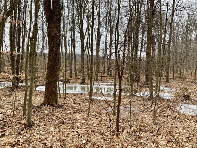
Around mile 0.13, hikers will pass a vernal pool that feeds part of the creek that flows down this part of the mountain. Depending on the time of year, and most of the time, this vernal pool is not overflowing, thus the creek that follows the trail is usually dry.
Short Seasonal Waterfalls - Mile 0.44
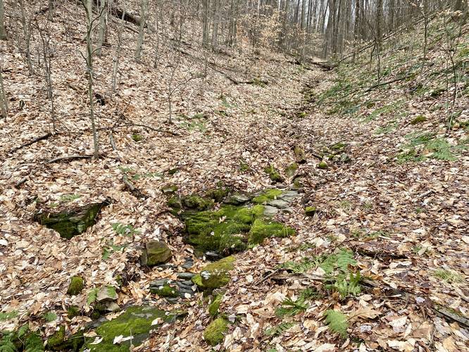
At mile 0.44, hikers will pass one 2-foot tall rock formation that sits within the creek. Just downstream of that is another 3.5 to 4-foot tall rock formation sitting in the creek as well - both create small waterfalls when the vernal pool upstream is overflowing water; however, this section of the creek is usually dry.
Creek Convergence - Mile 0.55
Around mile 0.55, hikers will find a bend in the trail as it leads away from the mountain hollows, near where another trickling creek converges, before it begins to follow the creek. Once reaching this section of the hike, there's really not much to see or experience outside of a peaceful forest walk.
Pipeline - Mile 1
At mile 1, hikers will reach a natural gas pipeline that cuts through the forest. Across the way, the trail continues, as it passes through a dark hemlock grove. The creek here is by far the most scenic as the hemlocks provide enough shade to keep the forest floor open and dark. The creek meanders its way through this forest before the hiker reaches the end of the trail - a private property line.
End of Trail / Private Property - Mile 1.05
At mile 1.05, hikers will reach the end of the trail, marked by Posted signs, as this is a private property line. Please respect the land owners and don't hike on their land. Turning back here completes the hike for approx. 2.1-mile out-and-back. The hike up the mountain is not difficult, but is not flat either - hence, the moderate difficulty.
Parking
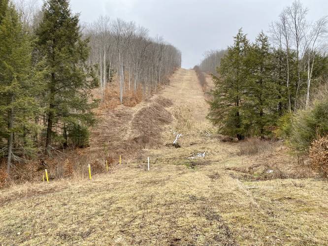
Hikers will find a make-shift parking turnout at the trailhead coordinates provided. At the time of this writing, mid-February 2023, there were two yellow fences that sit perpendicular to the service road, which can be used as both a marker to locate the trailhead and as a parking lot.
Pets
Dogs are allowed if leashed and their waste should be carried out by the hiker.
Camping & Backpacking
While there are no pre-defined campsites along this trail, backpackers and campers will find an open forest floor for the majority of this hike, making for a decent spot to setup a backcountry / primitive / dispersed campsite. Please follow all state forest rules when camping.
Short Seasonal Waterfalls
Note that this hike has "waterfalls", but they're very short - one is 2-feet tall and the other is 3.5 to 4-feet tall max. One waterfall, the 2-footer, is located on-trail and the other 4-footer is located just downstream slightly off-trail. These waterfalls are fed by the vernal pool that sits at the top of the mountain hollow. This vernal pool fills up slowly over time and thus the overflow from this is what feeds the run (creek) that flows down and over these rock formations, creating short waterfalls. Since the vernal pool slowly fills up over time, the best time to view these waterfalls after the snow begins to melt in early Spring or periods of heavy rains. During this winter hike, despite the warm temps we've had this winter, there was no water flowing down the creek; however, this may have been a different story a few weeks prior when the snow melted away.
Warnings
Hunting: This trail is a good place for hunters due to the open forest floor, vernal pool, and seclusion. Wearing blaze orange is smart on this hike, especially during Winter.
Timber Rattlesnake: The Timber Rattlesnake lives in these woods and thus, could be out roaming between late April and early October. They tend to like open, sunny, and rocky outcroppings, but they could be near water sources hunting or drinking.
Trails
This hike follows the Dewey Hollow Run Trail (multi-purpose, red blazed trail). Note that as of February 10, 2023, there are no blazes along this path.
Hike Description
This hike begins along the southern end of the wide service road portion of the Dewey Hollow Trail and follows the unmarked (no blazes or trailhead sign) Dewey Hollow Run Trail that leads down the mountain. At the beginning of the hike, the trail follows a mostly-flat grade as it makes its way toward a seasonal creek that flows down the mountain hollow, following the trail itself. Most of the forest here is wide open, making for good hunting.
Vernal Pool - Mile 0.13
Around mile 0.13, hikers will pass a vernal pool that feeds part of the creek that flows down this part of the mountain. Depending on the time of year, and most of the time, this vernal pool is not overflowing, thus the creek that follows the trail is usually dry.
Short Seasonal Waterfalls - Mile 0.44
At mile 0.44, hikers will pass one 2-foot tall rock formation that sits within the creek. Just downstream of that is another 3.5 to 4-foot tall rock formation sitting in the creek as well - both create small waterfalls when the vernal pool upstream is overflowing water; however, this section of the creek is usually dry.
Creek Convergence - Mile 0.55
Around mile 0.55, hikers will find a bend in the trail as it leads away from the mountain hollows, near where another trickling creek converges, before it begins to follow the creek. Once reaching this section of the hike, there's really not much to see or experience outside of a peaceful forest walk.
Pipeline - Mile 1
At mile 1, hikers will reach a natural gas pipeline that cuts through the forest. Across the way, the trail continues, as it passes through a dark hemlock grove. The creek here is by far the most scenic as the hemlocks provide enough shade to keep the forest floor open and dark. The creek meanders its way through this forest before the hiker reaches the end of the trail - a private property line.
End of Trail / Private Property - Mile 1.05
At mile 1.05, hikers will reach the end of the trail, marked by Posted signs, as this is a private property line. Please respect the land owners and don't hike on their land. Turning back here completes the hike for approx. 2.1-mile out-and-back. The hike up the mountain is not difficult, but is not flat either - hence, the moderate difficulty.
Parking
Hikers will find a make-shift parking turnout at the trailhead coordinates provided. At the time of this writing, mid-February 2023, there were two yellow fences that sit perpendicular to the service road, which can be used as both a marker to locate the trailhead and as a parking lot.
Pets
Dogs are allowed if leashed and their waste should be carried out by the hiker.
Camping & Backpacking
While there are no pre-defined campsites along this trail, backpackers and campers will find an open forest floor for the majority of this hike, making for a decent spot to setup a backcountry / primitive / dispersed campsite. Please follow all state forest rules when camping.
Short Seasonal Waterfalls
Note that this hike has "waterfalls", but they're very short - one is 2-feet tall and the other is 3.5 to 4-feet tall max. One waterfall, the 2-footer, is located on-trail and the other 4-footer is located just downstream slightly off-trail. These waterfalls are fed by the vernal pool that sits at the top of the mountain hollow. This vernal pool fills up slowly over time and thus the overflow from this is what feeds the run (creek) that flows down and over these rock formations, creating short waterfalls. Since the vernal pool slowly fills up over time, the best time to view these waterfalls after the snow begins to melt in early Spring or periods of heavy rains. During this winter hike, despite the warm temps we've had this winter, there was no water flowing down the creek; however, this may have been a different story a few weeks prior when the snow melted away.
Warnings
Hunting: This trail is a good place for hunters due to the open forest floor, vernal pool, and seclusion. Wearing blaze orange is smart on this hike, especially during Winter.
Timber Rattlesnake: The Timber Rattlesnake lives in these woods and thus, could be out roaming between late April and early October. They tend to like open, sunny, and rocky outcroppings, but they could be near water sources hunting or drinking.