The Deep Creek waterfalls loop outside of Bryson City is one of the
most popular hikes in Great Smoky Mountains National Park. This
relatively short hike is easy, scenic, and features 3 distinct
waterfalls. If you visit during the summer you may not find a parking
spot. Instead choose a weekday or the winter to check out the
waterfalls in relative peace and quiet. You’ll start on the wide, flat
Deep Creek Trail beside the namesake creek.
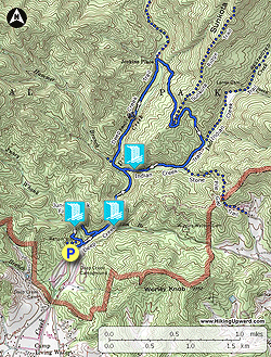
The creek is wide and large enough to accommodate inner tubes, a common scene during the summer weekends. First you’ll see the tall Tom Branch Falls from the comfort of the trail. The waterfall spills over many ledges directly into Deep Creek. Next you’ll leave some of the crowds behind as you tackle a loop from Deep Creek to Sunkota Ridge to Indian Creek. Along the way are many beautiful cascades and views along Deep Creek. The second waterfall, Indian Creek Falls, is also beside the trail. Before you return to the parking lot be sure to take the short side trip to Juney Whank Falls, where a bridge brings you across the middle of the waterfall. This loop is a great introduction to the national park without requiring too much effort.
The creek is wide and large enough to accommodate inner tubes, a common scene during the summer weekends. First you’ll see the tall Tom Branch Falls from the comfort of the trail. The waterfall spills over many ledges directly into Deep Creek. Next you’ll leave some of the crowds behind as you tackle a loop from Deep Creek to Sunkota Ridge to Indian Creek. Along the way are many beautiful cascades and views along Deep Creek. The second waterfall, Indian Creek Falls, is also beside the trail. Before you return to the parking lot be sure to take the short side trip to Juney Whank Falls, where a bridge brings you across the middle of the waterfall. This loop is a great introduction to the national park without requiring too much effort.
- Mile 0.0 – From the parking lot pick up the Deep Creek Trail paralleling the namesake creek.
- Mile 0.2 – T-junction with the Juney Whank Falls Trail on the left.
- Mile 0.4 – At a wide clearing you will see Tom Branch Falls dropping ~75 feet into Deep Creek. You can enjoy this waterfall without leaving the trail, and even relax on a bench.
- Mile 0.6 – Cross the first bridge over Deep Creek with benches and nice rapids upstream.
- Mile 0.9 – T-junction with the Indian Creek Trail on the right. Continue straight on the Deep Creek Trail across a bridge over Indian Creek. (If you are looking to shorten the hike, turn right here to visit Indian Creek Falls then turn around.)
- Mile 1.0 – Cross a second bridge over Deep Creek. On the other side of the bridge is a Y-junction with the Deep Creek Horse Trail on the left.
- Mile 1.5 – Good view of Sunkota Ridge rising above Deep Creek.
- Mile 1.9 – Cross a third bridge over Deep Creek. On the other side of the bridge the Deep Creek Trail turns left heading towards backcountry campsite #60 and the interior of the park. Turn right following the Loop Trail which climbs stoutly above Deep Creek to Sunkota Ridge.
- Mile 2.6 – T-junction with the beginning of the Sunkota Ridge Trail on the left. The Loop Trail now descends from the ridge through a drainage towards Indian Creek.
- Mile 3.1 – The Loop Trail ends at a T-junction with the Indian Creek Trail, turn right.
- Mile 3.4 – Y-junction with the Stone Pile Gap Trail on the left.
- Mile 3.8 – Cros a bridge over Indian Creek. Shortly after the bridge you’ll see Indian Creek Falls below the trail. A short trail leads to the base the ~25-foot slide waterfall.
- Mile 4.0 – The Indian Creek Trail ends at the Deep Creek Trail. Turn left heading back towards the parking lot.
- Mile 4.7 – Turn right on the Juney Whank Falls Trail which ascends through a deeply trenched dirt bank.
- Mile 4.8 – The trail briefly joins the Deep Creek Horse Trail then splits left toward the waterfall.
- Mile 4.9 – A wooden bridge over Juney Whank Branch provides an intimate view of Juney Whank Falls. After the waterfall the Juney Whank Falls Trail rejoins the Deep Creek Horse Trail.
- Mile 5.1 – Turn left on the Juney Whank Falls Trail heading down to the parking lot leaving the Deep Creek Horse Trail.
- Mile 5.2 – Hike ends at the Deep Creek parking lot.